
| Reference: | S39538 |
| Author | Reiner & Joshua OTTENS |
| Year: | 1730 ca. |
| Zone: | Turkish Empire |
| Printed: | Amsterdam |
| Measures: | 890 x 520 mm |
| Reference: | S39538 |
| Author | Reiner & Joshua OTTENS |
| Year: | 1730 ca. |
| Zone: | Turkish Empire |
| Printed: | Amsterdam |
| Measures: | 890 x 520 mm |
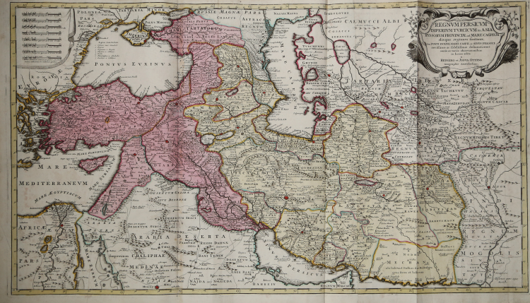
Striking map of the the Persian Empire, published by Reiner & Joshua Ottens.
The map shows the Kingdom of Persia, Ottoman Anatolia, Russia, the Caspian Sea and the Near Eastern environs, as it was divided in the early 1700s. There are two main colors that highlight territories, yellow being the Safavid Dynasty and the pink being the Ottoman Empire. The lands in the left hand corner of the map outlined in green are the lower south central lands of Russia. On the bottom left hand corner is land of the Kingdom of the Mongols.
Large population areas are marked by red stars such as Cairo, Constantinople, and Isfahan, only Medina is not marked in red. From these centers the marked roads show the primary trade routes; these are drawn as two parallel lines going in the same direction. Landmarks such as oasis's and forts and geographical formations are also drawn. Mountain ranges, rives lakes and the seas are all named and drawn.
Map taken from Atlas minor sive geographia compendiosa in qua orbid terrarum paucis attamen novissimis tablulis ostenditur - Atlas nouveau contenant toutes les parties du monde o๠sont exactement remarquées les empires, monarchies, royaumes,états, républiques, &c. Amsterdam, R. & J. Ottens (1756).
Copper engraving with fine original colouring, very good condition.
|
The family business of print and map selling was founded by Joachim Ottens but the active period of map publishing was concentrated in the years between 1720 and 1750 when the brothers, Reiner and Joshua, produced enormous collections of maps, some as large as 15 volumes.
These, including copies of practically all maps available at the time, were made up to order and were magnificently coloured. Besides these specially prepared collections they also issued single-volume atlases with varying contents as well as pocket atlases.
|
|
The family business of print and map selling was founded by Joachim Ottens but the active period of map publishing was concentrated in the years between 1720 and 1750 when the brothers, Reiner and Joshua, produced enormous collections of maps, some as large as 15 volumes.
These, including copies of practically all maps available at the time, were made up to order and were magnificently coloured. Besides these specially prepared collections they also issued single-volume atlases with varying contents as well as pocket atlases.
|