
| Reference: | 4057 |
| Author | Giovanni Antonio RIZZI ZANNONI |
| Year: | 1799 |
| Zone: | Northern Italy |
| Printed: | Naples |
| Measures: | - x - mm |
| Reference: | 4057 |
| Author | Giovanni Antonio RIZZI ZANNONI |
| Year: | 1799 |
| Zone: | Northern Italy |
| Printed: | Naples |
| Measures: | - x - mm |
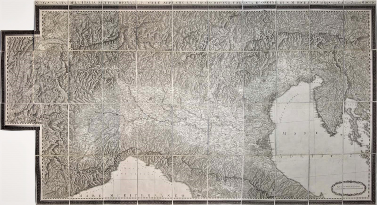
Map of Northern Italy and of the Alps, from Geneve to the gulf of Quarnero,from Florence to Austrian Tyrol. It is an enlargement and update of the map of Lombardia, published by Rizzi Zannoni in 1795. The map was commissioned by Ferdinando IV in 1799; it was realized in a 1:460.000 scale and engraved in 1800 by Giuseppe Guerra. The Neapolitan court had joined the alliance against France both with the army and with the realization of geographic maps which depicted military plans and the defence of the Italian borders. The Eastern sheet, depicting Istria and Quarnero, is a real novelty for the author had the chance to use a lot of unpublished cartographic data, deriving both from personal and direct observation, realized in 1778, and from the manuscripts he received from the geologist Alberto Fortis as a gift (Valerio, Società, Uomini, pp. 190-192). The mountains have been drawn by the painter Alessandro D’Anna; though he had never visited those places, he was able to depict the Alps with great skills. The map is decorated by a great Greek fret on a dark background, respecting the schemes and the forms of the paintings recently discovered in Pompei and Ercolano. The map remained valid for more than ten years; then new and direct research and measurements were realized by Italian and French geographers for the Deposito della Guerra in Milan. Very exceptional map, even more rare to be found in five sheets. Copper engraving, divided in 43 sections and laid on contemporary canvas, contained in a contemporary case, in excellent condition. Example sold by the bookshop Artaria in Vienna. Extremely rare. Dim. 1480x875.
Valerio, Società, Uomini . . ., Firenze 1993, p. 190/2; Terre di Langobardia p. 178, 83.
Giovanni Antonio RIZZI ZANNONI (1736 - 1814)
|
Rizzi Zannoni was a noted astronomer, surveyor and mathematician of great versatility. His achieevements included a large scale map of Poland, appointmenys as Geographer to the Venetian Republic and as Hydrographer to the Dèpot de Marine in Paris. The maps in his various atlases were beatifully engraved, showing minute details and embellished with elaborate cartouches. His earlier atlases were published in Paris but his later works first appeared in Naples.
Principali pubblicazioni:
1762 Atlas géographique
1763 Atlas Géographique et militaire
1765 Le petit Neptune Francois
1772 Carte Générale de la Pologne
1792 Atlante Maritimo delle due Sicilie
1795 Nuova carta della Lombardia
|