| Reference: | S9029 |
| Author | Emanuele TESAURO |
| Year: | 1672 |
| Zone: | Scandinavia |
| Printed: | Venice |
| Measures: | 185 x 135 mm |
| Reference: | S9029 |
| Author | Emanuele TESAURO |
| Year: | 1672 |
| Zone: | Scandinavia |
| Printed: | Venice |
| Measures: | 185 x 135 mm |
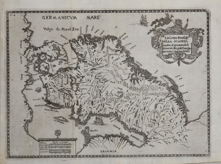
Map taken from "Del Regno D'italia Sotto I Barbari" by Tesauro, D. Emanuel and with annotations of D. Valeriano Castiglione, printed by Giacomo Hertz, Venetia (Venice), 1672.
History of Italian monarchs during darkest of the Dark Ages, or the period following the fall of the Roman Empire til around 1000 A.D., with 3 double-page engraved maps of Sweden, Lombardy, and Piedmont.
This striking and uncommon map of Scandinavia includes nice topographical detail, with the region's mountains and forests graphically depicted. Place names are mostly concentrated along the coasts, although there are some scattered about the interior. A sailing ship appears in the Gulf of Bothnia, and another is shown in the Norwegian Sea, here called Germanicum Mare Vulgo de Noord Zee. The decorative title cartouche at top right features two coats of arms and a stately lion wearing a crown and holding a flag, axe, and scepter.
The author, Emanuele Tesauro (1592-1675), dramatist and rhetorician, chiefly celebrated as a Marinist poet, served as court historian to the dedicatee, Charles Emanuel II Duke of Savoy (1634-75), who sponsored some of the finest architecture in Turin and savagely suppressed the Waldenses.
Copperplate, good condition.
Emanuele TESAURO(Torino 1592 - 1675)
Emanuele TESAURO(Torino 1592 - 1675)