| Reference: | S20615 |
| Author | Adolf STIELER |
| Year: | 1880 ca. |
| Zone: | Denmark |
| Printed: | Gotha |
| Measures: | 476 x 385 mm |
| Reference: | S20615 |
| Author | Adolf STIELER |
| Year: | 1880 ca. |
| Zone: | Denmark |
| Printed: | Gotha |
| Measures: | 476 x 385 mm |
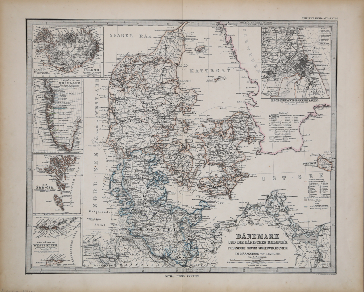
Amazing detail and precisely engraved. Insets show the Virgin Islands in the West Indies, the southern portion of Greenland, Iceland, and the Fareo Island group. The fifth inset is a large and finely engraved plan of Copenhagen.
Crisp, fine impression and beautiful hand coloring.
Adolf STIELER (Gotha 1775 - 1836)
|
Adolf Stieler (26 February 1775 – 13 March 1836) was a German cartographer and lawyer who worked most of his life in the Justus Perthes Geographical Institute in Gotha. Although he studied law and would serve in government for his entire career, he maintained an interest in cartography and published many famous works. His Handatlas was the leading German world atlas until the middle of the 20th century.
Stieler's cartographic career began with a position as a geography teacher at a girls' school in Gotha. However, he began work with Franz Xaver von Zach, the director of the Gotha Observatory. His works during this period include publishing cartographic representations of a number of von Zach's observations. Such illustrations were completed in von Zach's "Allgemeinen Geographischen Ephemeriden" or "General Geographical Ephemeris," published in 1798.
Map of Southeast Asia, printed in Stielers Handatlas.
In 1804, Stieler worked in the Geographical Institute of Weimar, continuing his goal of starting a geographical publishing business.
He also produced a number of regional and international maps. With von Zach, Stieler published his "Atlas Gaspari," which included maps of many European nations, including Spain, Portugal, and England.[3] In 1806, his map of the East Indies was published. Later he would publish a 25 sheet military map of Germany that was part of a larger 204 sheet work. His maps were well known for their inclusion of new information from exploration and culture. He also incorporated a "System der fortwährenden Modernisierung," or "System of Ongoing Modernization," in his map creation and issuing.
However, he began work on his most famous and long-lasting work, the Handatlas, in 1816 after a long hiatus from cartographic work. By 1826, when he completed the Handatlas, his career was nearing its end. His 1836 map of Germany would remain unfinished.
|