| Reference: | S4690 |
| Author | Didier Robert de VAUGONDY |
| Year: | 1772 |
| Zone: | Tartary |
| Printed: | Paris |
| Measures: | 380 x 310 mm |
| Reference: | S4690 |
| Author | Didier Robert de VAUGONDY |
| Year: | 1772 |
| Zone: | Tartary |
| Printed: | Paris |
| Measures: | 380 x 310 mm |
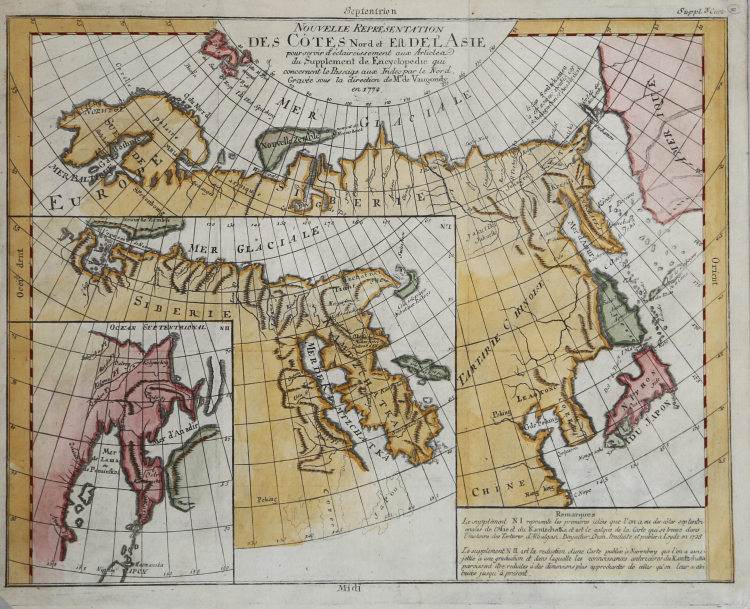
Fascinating study of the prevailing theories regarding the Northeast Coast of Asia during the second half of the 18th Century, prepared by Diderot.
The 10 maps which accompany the supplement to Diderot's Encyclopedia are one of the earliest studies of comparative cartography, compiling the most modern variant theories and setting them out side by side or in a series of maps.
This set of 3 maps focuses on the 3 theories of the NE Coast of Asia as reported by various German & Russian explorers. The NE Passage is the focal point of this map, contasting the reports of three 18th Century cartographers. Gorgeous full color example.
Didier Robert de VAUGONDY (1723 ca. - 1786)
|
Didier Robert de Vaugondy (1723-1786) was appointed Geographer to Louis XV in 1760. At the same time, de Vaugondy served as Geographer to the Duke of Lorraine and Bar, father-in-law to Louis XV and former King of Poland.
His major contributions to French cartography are the Atlas Universel, 1750-57, The Nouvelle Atlas Portatif (1784) and a very popular map of North America published in 1761. He was son of Gilles Robert de Vaugondy who succeeded Pierre Sanson as the King's Geographer.
|