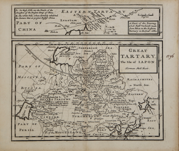
| Reference: | ms5864 |
| Author | Herman MOLL |
| Year: | 1720 ca. |
| Zone: | Tartary |
| Printed: | London |
| Measures: | 107 x 170 mm |
| Reference: | ms5864 |
| Author | Herman MOLL |
| Year: | 1720 ca. |
| Zone: | Tartary |
| Printed: | London |
| Measures: | 107 x 170 mm |
From "The Compleat Geographer or the Chorography and Topography of all the known parts of the Earth", published in 1723 by HERMAN MOLL (fl.1678-1732).
A Dutchman, was a bookseller, geographer and engraver. He moved to London, in c.1678, where he worked for a while as an engraver. Later he started his own business as a map publisher.
He became the foremost in his field at the beginning of the 16th century, producing loose maps and atlases, including miniatures and large, highly decorative maps.
|
Herman Moll came to London in about 1678 and worked as an engraver for other publishers, such as Moses Pitt, Greenville Collins. John Adair, and Seller & Price, but soon set up his own business publishing atlases and also separate maps of all parts of the world. His work was varied, ranging from miniature maps to large very decorative wall maps. The first maps engraved by Moll in his own right were prepared for the atlas volume accompanying Sir Jonas Moore’s New System Of The Mathematicks …, in which he began to develop his characteristic engraving style.
Maps in Moll’s large folio atlas, The World Described are clearly printed with large cartouches, enclosing the title and dedication and often with large vignettes. This atlas contained one of the largest world maps of the early eighteenth century to appear in atlas form. Published in 1724 the map is somewhat outdated (despite its author’s claims), showing California as an Island long after the French maps of around 1700 had depicted it as a peninsula. Perhaps his most famous map is the New and Exact Map of the Dominions of the King of Great Britain on ye Continent of North America, depicting the English colonies along the east coast. The map is more popularly called the “Beaver Map”, after the attractive vignette scene showing beavers building dams.
Jonathan Swift, it is said, referred to Moll’s maps in the writing of Gulliver’s Travels, thereby adding greater credibility to his story by ensuring the location of the islands visited by Gulliver could not be disputed.
Moll’s other works include the Atlas Manuale (1709), New and Complete Atlas (1719), the Atlas Minor (1729) and Atlas Geographus (1711-17) in five volumes.
Moll also published a fine series of county maps, in the New Description of England, published in 1724. The maps are famous for their side panels with drawings of architectural remains from the counties. His work was much copied by other publishers and he enjoyed a high reputation.
|
|
Herman Moll came to London in about 1678 and worked as an engraver for other publishers, such as Moses Pitt, Greenville Collins. John Adair, and Seller & Price, but soon set up his own business publishing atlases and also separate maps of all parts of the world. His work was varied, ranging from miniature maps to large very decorative wall maps. The first maps engraved by Moll in his own right were prepared for the atlas volume accompanying Sir Jonas Moore’s New System Of The Mathematicks …, in which he began to develop his characteristic engraving style.
Maps in Moll’s large folio atlas, The World Described are clearly printed with large cartouches, enclosing the title and dedication and often with large vignettes. This atlas contained one of the largest world maps of the early eighteenth century to appear in atlas form. Published in 1724 the map is somewhat outdated (despite its author’s claims), showing California as an Island long after the French maps of around 1700 had depicted it as a peninsula. Perhaps his most famous map is the New and Exact Map of the Dominions of the King of Great Britain on ye Continent of North America, depicting the English colonies along the east coast. The map is more popularly called the “Beaver Map”, after the attractive vignette scene showing beavers building dams.
Jonathan Swift, it is said, referred to Moll’s maps in the writing of Gulliver’s Travels, thereby adding greater credibility to his story by ensuring the location of the islands visited by Gulliver could not be disputed.
Moll’s other works include the Atlas Manuale (1709), New and Complete Atlas (1719), the Atlas Minor (1729) and Atlas Geographus (1711-17) in five volumes.
Moll also published a fine series of county maps, in the New Description of England, published in 1724. The maps are famous for their side panels with drawings of architectural remains from the counties. His work was much copied by other publishers and he enjoyed a high reputation.
|