
| Reference: | S39547 |
| Author | Hendrick de Leth |
| Year: | 1707 ca. |
| Zone: | Egypt, Ethiopia |
| Printed: | Amsterdam |
| Measures: | 570 x 490 mm |
| Reference: | S39547 |
| Author | Hendrick de Leth |
| Year: | 1707 ca. |
| Zone: | Egypt, Ethiopia |
| Printed: | Amsterdam |
| Measures: | 570 x 490 mm |
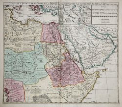
Prepared by G.de l'Isle. Uncommon issue by Hendrik de Leth. Very detailed map of northeastern Africa, the Red Sea and the Arabian peninsula shows the political divisions and kingdoms, roads, topography, settlements, encampments and much more.
A fine example of Guillaume De L'Isle's highly detailed map of the region centered on the Red Sea.
The map extends west to include Sicily, the Southeastern Mediterranean, Barbarie, Nigritie, and Guinea on the West Coast of Africa. To the east, the map includes the Persian Gulf, Saudi Arabia, the Gulf of Aden and the Kingdom of Ajan and Dadel.
De L'Isle's maps provided the first truly scientific mapping of the regions covered, eschewing the flamboyant Dutch style of illustrations and adopting a highly detailed and decorative approach to the printed map.
Guillaume de l'Isle (1675-1726) was the son and pupil of the cartographer Jean Dominique Cassini, who, among other important contributions, aligned the study of astronomy to the study of geography. Under Cassini's direction, observations were made from locations all over the world that enabled longitudinal calculations to be made with much greater accuracy.
De l'Isle carried on this exacting work with remarkable dedication and integrity, constantly revising and improving his maps. While precision was his primary goal, his maps are invariably elegant and attractive. Jean (Johannes) Covens and Corneille (Cornelius) Mortier were brothers-in-law, who carried on the book publishing business established by Pierre Mortier in Amsterdam in 1685.
Pierre Mortier's company owed much of its success to his access to French publishers, whose publications he re-issued in handsome editions. The elder Mortier died in 1711; his wife continued the firm until she died in 1719. In 1721, Covens and Mortier formed a partnership, Covens having married Agatha Mortier in the same year. They continued the business by publishing enlarged editions of Sanson, Jaillot, and De L'Isle, as well as some of the later Dutch cartographical masters such as De Wit and Allard, and of course Pierre Mortier.
This map is from an edition of De L'Isle entitled, Atlas Nouveau, Contenant Toutes Les Parties Du Monde, Ou sont exactement Remarquées les Empires, Monarchies, Royaumes, Etats, Republiques &c. Par Guillaume de l'Isle. Premier Géographe de sa Majesté. It delineates the island in great detail.
At the time the map was made, the coastal areas were ruled by the Dutch East Indian Company, who were undoubtedly responsible for the soundings indicated around the island and for mapping the roads depicted. Copper engraving, contemporary colour, in perfect condition.
Hendrick de Leth (Attivo ad Amsterdam tra il 1703 e il 1766)
|
Printmaker and draughtsman of landscapes, active in Amsterdam.
|
Hendrick de Leth (Attivo ad Amsterdam tra il 1703 e il 1766)
|
Printmaker and draughtsman of landscapes, active in Amsterdam.
|