
| Reference: | S39450 |
| Author | Georg BRAUN & Franz HOGENBERG |
| Year: | 1572 ca. |
| Zone: | Kairo |
| Printed: | Antwerpen & Cologne |
| Measures: | 490 x 330 mm |
| Reference: | S39450 |
| Author | Georg BRAUN & Franz HOGENBERG |
| Year: | 1572 ca. |
| Zone: | Kairo |
| Printed: | Antwerpen & Cologne |
| Measures: | 490 x 330 mm |
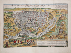
A richly detailed bird’s eye view filled with fascinating detail. The pyramids and Sphinx at Giza can be seen at the right, while the Nile River runs in the foreground of the city that is depicted from the west. Gezira Island, already quite well developed on the plan, and now occupying the center of the modern city, can be seen at the right near the pyramids. The table at lower right identifies the figures to the left and other prominent features of the plan.
Derived from the famous wall plan by Giovanni Domenico Zorzi and Matteo Pagano, printed in Venice in 1549: “Nel 1549 Matteo Pagano, in collaborazione con il pittore e cartografo Giovanni Domenico Zorzi, produce questa grande mappa del Cairo, composta da ventuno blocchi silografici. La prospettiva adottata, obliqua dall’alto, detta “a volo d’uccello”, segue la tradizione rinascimentale della rappresentazione delle città. Il formato è orizzontale, con la città vista dalla riva occidentale del Nilo. Sono indicati in maniera chiara sia aree individuali che monumenti della città, come il distretto di Azbakiya, la porta di Bab Zuwayla, l’acquedotto e le vie principali, il Vecchio Cairo, sviluppato intorno alla fortezza di Babilonia, la torre di Giza, le celebri Piramidi e la Sfinge in sembianze femminili. All’interno del denso agglomerato urbano si distinguono alcuni edifici, come la MADRASA del sultano Hasan, la casa dove – secondo la tradizione biblica – si rifugiò la Vergine durante il passaggio in Egitto, così come gli accessi principali. La disposizione delle mura settentrionali e orientali della città e della Cittadella è indicativa ma topograficamente accurata. La carta dello Zorzi comunque va al di là della mera rappresentazione spaziale della città. Le vignette storiche che mostrano l’ingresso dell’esercito ottomano di Selim alle porte del Cairo nel 1517 danno all’opera una specifica collocazione temporale. Decorano la mappa numerose scene di vita quotidiana, dalla raccolta dei datteri, al trasporto dell’acqua, agli esercizi della cavalleria, alle scene di costume, ed anche la fauna locale: cammelli, coccodrilli, asini. L’opera è integrata da testo disposto in forma di didascalie, come nella veduta della città pubblicata nella Peregrinatio in Terram Sanctam di Bernhard von Breydenbach (1486), ma con un intento descrittivo più ampio. Si ritiene che queste didascalie derivino dall’opera Descriptio Alcahirae Urbis Quae Mizir Et Mazar Dicitur, attribuita al cosmografo e umanista francese Guillaume Postel, ed edita da Matteo Pagano nel 1549. In assenza di una data sulla lastra, questo pamphlet rappresenta l’unico criterio di datazione dell’opera, che risalirebbe quindi alla metà del secolo XVI. La rappresentazione, invece, si riferisce alla situazione del Cairo alla fine del ’400, infatti sono riportate costruzioni che risalgono all’epoca del sultano Qaybay, quando le relazioni tra l’Egitto e Venezia erano molto forti. Non si conoscono le fonti utilizzate da Pagano per la realizzazione di questa grande veduta. Sono state formulate diverse ipotesi: che potesse esistere un originale, perduto, risalente alla fine del XV secolo, successivamente integrato con le didascalie relative alla conquista di Selim (1517); oppure che la veduta di Pagano sia una copia – con varianti– di quella dipinta, oggi perduta, che era stata realizzata per Francesco II Gonzaga per il palazzo a Gonzaga o per Palazzo San Sebastiano a Mantova (1506-1512). Proprio l’evidenza documentaria relativa all’esistenza di questa veduta murale, suggerisce che all’epoca potesse circolare una versione a stampa che probabilmente ha ispirato questa pubblicazione di Pagano. La questione rimane evidentemente aperta. Per ogni approfondimento, si rimanda alla monumentale monografia di Nicholas Warner, The true description of Cairo (2006). Ciò che contraddistingue la rappresentazione di Pagano del Cairo è l’agglomerato urbano denso di costruzioni, che includono moschee, tombe, palazzi, e la relativa cura della rappresentazione topografica. Per la prima volta veniva offerta un’immagine di una città orientale che ben rappresentava la sua grandezza e la sua complessità, ma anche la sua importanza socio-economica-politica per cui era in grado di competere con i centri storici d’Europa. Sebbene l’opera sopravviva solo attraverso tre esemplari, ha avuto un’influenza enorme: attraverso derivazioni, tutte di formato più piccolo, rimase in circolazione per i successivi due secoli come immagine incontrastata di quella che era la più grande città del Medio Oriente e del nord Africa. Bisognerà attendere il XVIII secolo per vedere un’immagine del Cairo diversa e più realistica che immaginaria” (cfr. S. Bifolco – F. Ronca, Cartografia e topografia italiana del XVI secolo, p. 491).
The work is included in the Civitates Orbis Terrarum, the first atlas devoted exclusively to plans and views of the world's major cities. Printed in six volumes between 1572 and 1617 it was so successful and widespread that several editions translated into Latin, German and French were printed.
The first volume of the Civitates Orbis Terrarum was published in Cologne in 1572. The sixth and the final volume appeared in 1617. This great city atlas, edited by Georg Braun and largely engraved by Franz Hogenberg, eventually contained 546 prospects, bird-eye views and map views of cities from all over the world. Fransz Hogenberg produced the plates for the first four books, and Simon van den Neuwel (Novellanus, active since 1580) those for volumes V and VI.
Georg Braun (1541-1622), a cleric of Cologne, was the principal editor of the work, and was greatly assisted in his project by the close, and continued interest of Abraham Ortelius, whose Theatrum Orbis Terrarum of 1570 was, as a systematic and comprehensive collection of maps of uniform style, the first true atlas. The Civitates, indeed, was intended as a companion for the Theatrum, as indicated by the similarity in the titles and by contemporary references regarding the complementary nature of two works. Nevertheless, the Civitates was designs to be more popular in approach, no doubt because the novelty of a collection of city plans and views represented a more hazardous commercial undertaking than a world atlas, for which there had been a number of successful precedents. Franz Hogenberg (1535-1590) was the son of a Munich engraves who settled in Malines. He engraved most of the plates for Ortelius's Theatrum and the majority of those in the Civitates, and may have been responsible for originating the project.
Over a hundred of different artists and cartographers, the most significant of whom was Antwerp artist Georg Hoefnagel (1542-1600), engraved the cooper-plates of the Civitates from drawings. He not only contributed most of the original material for the Spanish and Italian towns but also reworked and modified those of other contributors. After Hoefnagel's death his son Jakob continued the work for the Civitates.
The author set out to depict "non icones et typi urbium," that is, not generic and typified images, "sed urbes ipsae admirabili caelaturae artificio, spectantium oculis subiectae appareant": not intended to allude or idealize but to represent faithfully on paper, to reproduce exactly, and in real time, what the eye sees, as announced in the preface to the first volume of Civitates Orbis Terrarum.
Etching on copperplate with fine later hand colour, in good conditions.
|
George Braun (1541-1622), cleric of Cologne, was the principal editor of the Civitates Orbis Terrarum, and was greatly assisted in his project by the close, and continued interest of Abraham Ortelius, whose Theatrum Orbis Terrarum of 1570 was, as a systematic and comprehensive collection of maps of uniform style, the first true atlas.
Franz Hogenberg (1535-1590) was the son of a Munich engraves who settled in Malines. He engraved most of the plates for Ortelius's Theatrum and the majority of those in the Civitates, and may have been responsible for originating the project.
|
|
George Braun (1541-1622), cleric of Cologne, was the principal editor of the Civitates Orbis Terrarum, and was greatly assisted in his project by the close, and continued interest of Abraham Ortelius, whose Theatrum Orbis Terrarum of 1570 was, as a systematic and comprehensive collection of maps of uniform style, the first true atlas.
Franz Hogenberg (1535-1590) was the son of a Munich engraves who settled in Malines. He engraved most of the plates for Ortelius's Theatrum and the majority of those in the Civitates, and may have been responsible for originating the project.
|