| Reference: | s34968 |
| Author | Henrick SCHERER |
| Year: | 1702 ca. |
| Zone: | Pacific Ocean |
| Printed: | Munich |
| Measures: | 348 x 236 mm |
| Reference: | s34968 |
| Author | Henrick SCHERER |
| Year: | 1702 ca. |
| Zone: | Pacific Ocean |
| Printed: | Munich |
| Measures: | 348 x 236 mm |
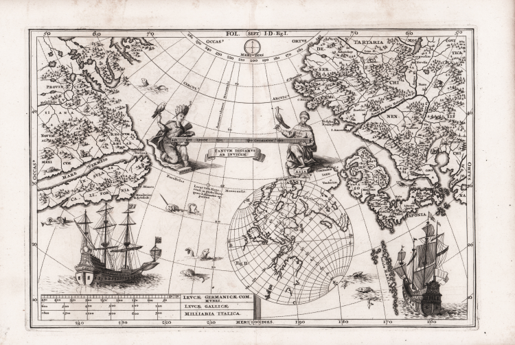
Interesting map of the Pacific Ocean North West of America and the North East of Asia by Heirich Scherer for his Atlas Novus exhibens orbem terraguem per naturae opera, historiae navae acveterus monumenta, artistique geographicae leges et praecepta...published in eight volumes from 1702-1710 in Munich. Scherer, a devout Jesuit, produced this geographical compendium to depict the Catholic hierarchy and the spread of Jesuit missions throughout the world.
The map reflects the European knowledge of the Pacific North West of America and the North East of Asia in the early 18th century. The most striking aspect of the map is that it is projected as a mirror image of the actual surface geography with Japan in the east and North America in the West.
Of particular interest with this rare map is the depiction of California. California was for the the better part of a century depicted as an island. However, this theory would be disproved following Father Eusebio Francisco Kino’s mission to Baja California in 1701. Although his findings would only be published 1705, cartographers such as Scherer and Nicolas De Fer began to contemplate Baja California as a peninsula. That being said, this map continues to perpetuate the California as an island myth.
Two figures are shown on the map: the first is positioned on the left side of the title cartouche and depicts a Native American. The second figure, parallel to the figure on the left side, is dressed in Middle Eastern garments with a hawk perching on his outstretched hand.
The map in also decorated with two ships and sea monsters.
Copper engraving, in very good condition.
Henrick SCHERER (Dilingen 1628 - Monaco 1704)
|
Heinrich Scherer was a devout Jesuit, and professor of mathematics at Munich. His 'Atlas Novus' contained maps of all other parts which showed the spread of Catholicism and Jesuit missions.
|
Henrick SCHERER (Dilingen 1628 - Monaco 1704)
|
Heinrich Scherer was a devout Jesuit, and professor of mathematics at Munich. His 'Atlas Novus' contained maps of all other parts which showed the spread of Catholicism and Jesuit missions.
|