
| Reference: | S377610 |
| Author | Paolo PETRINI |
| Year: | 1696 ca. |
| Zone: | Naples |
| Printed: | Naples |
| Measures: | 1150 x 500 mm |
| Reference: | S377610 |
| Author | Paolo PETRINI |
| Year: | 1696 ca. |
| Zone: | Naples |
| Printed: | Naples |
| Measures: | 1150 x 500 mm |
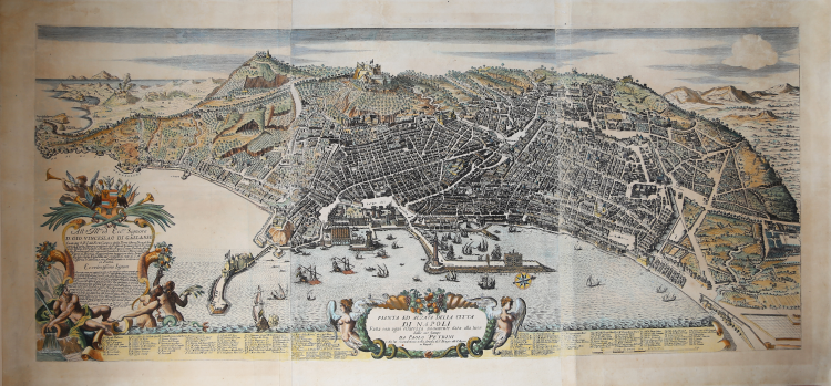
Rare bird's eye view of Naples, first published in 1696. Example of the third edition, with the imprint "Napoli 1748".
Petrini's view is the first map of great editorial work produced in Naples for clear commercial purposes.
Although its derivation from the great seventeenth-century view of Orlandi - Perrey - Baratta is evident, this plant, with its particular geographical construction, will become a reference prototype for the future cartographic production.
The view is dedicated to the Marquis Pompeo Azzolini.
Between 1967 and 1698, the map was implemented with the inclusion of twenty-one views of the city to frame the great central view.
The delineator of both the central and the surrounding views was Francesco Cassiano de Silva.
On the left and in the center, two decorative cartouches with dedication and title, both adorned with figures, floral decorations and, on the left one, a coat of arms.
Etching engraving finished with burin. A good impresson, printed on laid paper, with original colouring (refreshed), in good condition.
|
Ermanno Bellucci, Vladimiro Valerio, Piante e Vedute di Napoli dal 1600 al 1699, p.162
|
Paolo PETRINI (Attivo a Napoli fine del XVIII secolo)
|
very little is known about Petrini except that for many years he was a publisher and map seller in Naples producine large and small maps often slavishly based on those by Guillaume Sanson and Nicolas de Fer. About 1718 he published a large-scale plan of Naples. All his work is very rare.
1700 Atlante Partenopea
1700 Mappa Mondo Vero Carta
1700 ca. Maps of the wolrd and continents (wall maps)
|
|
Ermanno Bellucci, Vladimiro Valerio, Piante e Vedute di Napoli dal 1600 al 1699, p.162
|
Paolo PETRINI (Attivo a Napoli fine del XVIII secolo)
|
very little is known about Petrini except that for many years he was a publisher and map seller in Naples producine large and small maps often slavishly based on those by Guillaume Sanson and Nicolas de Fer. About 1718 he published a large-scale plan of Naples. All his work is very rare.
1700 Atlante Partenopea
1700 Mappa Mondo Vero Carta
1700 ca. Maps of the wolrd and continents (wall maps)
|