| Reference: | S49234 |
| Author | Reale Officio Topografico |
| Year: | 1828 |
| Zone: | Naples |
| Printed: | Naples |
| Measures: | 1040 x 800 mm |
| Reference: | S49234 |
| Author | Reale Officio Topografico |
| Year: | 1828 |
| Zone: | Naples |
| Printed: | Naples |
| Measures: | 1040 x 800 mm |
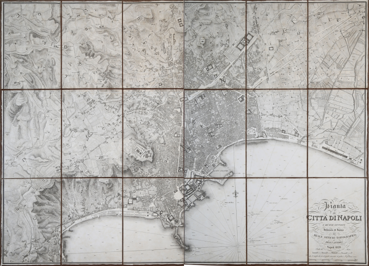
First and rare edition of the important and detailed plan of the city of Naples printed by the Reale Officio Topografico [Royal Topographical Office] in 1828, a model for all topographical maps of the city in the 19th century.
“La pianta di Napoli in scala 1:8000 circa (il rapporto varia da copia a copia) è uno dei primi e più importanti prodotti dell'Officina Topografica di Napoli. La sua ideazione deve risalire al 1814, anno di istituzione del Deposito della guerra, ma il rilevamento fu portato a compimento negli anni successivi dall'ingegnere geografo Giosuè Russo, coadiuvato da altri impiegati dell'Officio. Nel 1820 il rame doveva essere già avviato ed a buon punto se nel novembre del 1821 l'ingegnere Russo informava i suoi superiori circa le difficoltà incontrate nelle ricognizioni da effettuare nelle proprietà private per correggere e aggiornare il rame della gran pianta della città. Nel febbraio del 1823, in una relazione sullo stato dei lavori nell'Officio, si prevedeva un anno e quattro mesi di lavoro ininterrotto di un incisore per portare a compimento il rame. In effetti di anni ne passarono ben cinque e solo nel 1828 la nuova pianta della città vide la luce. In precedenza, era stato pubblicato, nel 1824, il «Piano idrografico» del porto e della rada di Napoli, che ripropone identicamente (ma in litografia) il tratto costiero della pianta generale. […] La pianta di Napoli, come altri prodotti significativi dell'Officio, continuò ad essere aggiornata. Se ne conoscono copie con aggiornamenti datati al 1853, al 1865, al 1872 ed al 1873, che è la data dell'ultimo aggiornamento eseguito. La carta fu venduta fino agli anni Ottanta del secolo scorso dall'Istituto Geografico Militare. Tra le particolarità del «Piano» e della pianta del 1828 va segnalata la individuazione a mare delle navi incendiate ed affondate nel 1799: il «vascello S. Gioacchino», la «Gabarra Francese», la «Fregata Pallade e la «Corvetta Flora», nonché alcuni «quartieri di bastimento» che creavano intralcio alla navigazione o problemi di ancoraggio in rada. Alcuni simboli letterali sono posti accanto agli scandagli (espressi in piedi parigini pari a cm 32,48): «fan.» indica fondo fangoso e «ar.>> fondo arenoso. A questi elaborati si rifanno le più importanti piante di Napoli e della sua rada pubblicate nel corso del XIX secolo” (cfr. Vladimiro Valerio, La città di Napoli tra vedutismo e cartografia, pag. 334).
After the national and international success of the map published in 1828, other versions were drawn up: a first one in 1853, an update covering the years between 1828 and 1865, and a final edition produced in 1873. The map is also of extreme interest because a good part of the military institutions in the city are identified: the “Stations of the Royal Carabinieri,” the “Headquarters of the Legions of the National Guard,” the “Military Establishments,” and the “Pavilions for widowed officers and orphans”.
The Reale Officio Topografico was a military scientific institute in Naples, responsible for the construction of topographical, geographical and hydrographic maps of the Kingdom of the Two Sicilies. Founded in the Rosario di Palazzo area in 1781 under the name of Deposito Topografico by Giovanni Antonio Rizzi Zannoni, it was later transferred to Pizzofalcone. Rizzi Zannoni arrived in Naples in 1781 with the task of founding and directing the first Reale Officio Topografico in Naples, destined to become one of the first state cartographic institutions in Europe, bringing with him all his instruments and his entire geographic archive. Favored by the benevolence of Ferdinand IV, who was always very attentive to scientific progress, and overcoming the opposition of his contemporaries, Abbot Galiani, overcoming various and complex oppositions in the royal court, promoted the purchase of modern instruments, suggested by Rizzi Zannoni, and obtained very large premises (in the Rosario area of the Palace) where the cartographic laboratories were implanted and he himself was appointed Commissioner of the enterprise. With the establishment of the Officio Topografico, important draughtsmen, cartographers and mathematicians came to Naples and became part of the laboratory, which became a high-level school in the preparation of maps, contributing to its records until the fall of the Bourbon dynasty.
Etching, impressed on paper and applied to contemporary cloth backing, folded several times to case. Slight oxidation, otherwise in very good condition. Very rare.
Bibliografia
Vladimiro Valerio, La città di Napoli tra vedutismo e cartografia, pag. 334.
|
The Reale Officio Topografico [Royal Topographical Office] was a military scientific institute in Naples responsible for the construction of topographical, geographical and hydrographic maps of the Kingdom of the Two Sicilies. Founded in the Rosario di Palazzo area in 1781 under the name of Deposito topografico by Giovanni Antonio Rizzi Zannoni, it was later transferred to Pizzofalcone. Rizzi Zannoni arrived in Naples in 1781 with the task of founding and directing the first Reale Officio Topografico in Naples, destined to become one of the first state cartographic institutions in Europe, bringing with him all his instruments and his entire geographic archive.
Favored by the benevolence of Ferdinand IV, who was always very attentive to scientific progress, and overcoming the opposition of his contemporaries, Abbot Galiani, overcoming various and complex oppositions in the royal court, promoted the purchase of modern instruments, suggested by Rizzi Zannoni, and obtained very large premises (in the Rosario area of the Palace) where the cartographic laboratories were implanted and he himself was appointed Commissioner of the enterprise.
With the establishment of the Officina Topografica important draughtsmen, cartographers and mathematicians came to Naples and became part of the laboratory, which became a high-level school in the preparation of maps, contributing to its records until the fall of the Bourbon dynasty.
|
|
The Reale Officio Topografico [Royal Topographical Office] was a military scientific institute in Naples responsible for the construction of topographical, geographical and hydrographic maps of the Kingdom of the Two Sicilies. Founded in the Rosario di Palazzo area in 1781 under the name of Deposito topografico by Giovanni Antonio Rizzi Zannoni, it was later transferred to Pizzofalcone. Rizzi Zannoni arrived in Naples in 1781 with the task of founding and directing the first Reale Officio Topografico in Naples, destined to become one of the first state cartographic institutions in Europe, bringing with him all his instruments and his entire geographic archive.
Favored by the benevolence of Ferdinand IV, who was always very attentive to scientific progress, and overcoming the opposition of his contemporaries, Abbot Galiani, overcoming various and complex oppositions in the royal court, promoted the purchase of modern instruments, suggested by Rizzi Zannoni, and obtained very large premises (in the Rosario area of the Palace) where the cartographic laboratories were implanted and he himself was appointed Commissioner of the enterprise.
With the establishment of the Officina Topografica important draughtsmen, cartographers and mathematicians came to Naples and became part of the laboratory, which became a high-level school in the preparation of maps, contributing to its records until the fall of the Bourbon dynasty.
|