

| Reference: | S48518 |
| Author | Johannes JANSSONIUS |
| Year: | 1657 ca. |
| Zone: | Milan |
| Printed: | Amsterdam |
| Measures: | 515 x 405 mm |
| Reference: | S48518 |
| Author | Johannes JANSSONIUS |
| Year: | 1657 ca. |
| Zone: | Milan |
| Printed: | Amsterdam |
| Measures: | 515 x 405 mm |
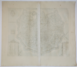
Perspective plan first published, circa 1657, by Johannes Janssonius, here in the circa 1680 reprint by Frederick de Wit.
This is a faithful copy of Braun and Hogenberg's 1572 map with variations in the position and composition of the cartouches and a slightly larger size. On the upper right is the coat of arms with the Visconti bison. In the lower margin are 81 key references to the most representative places and monuments in two columns.
It is first published in the collection of Johannes Janssonius, Theatrum urbium Italiae aliarumque in insulis Maris Mediterraneae, Amsterdam s.d. (c. 1657). Janssonius set out to renew the success enjoyed by Braun's Civitates orbis terrarum and succeeded in acquiring the collection of plates from the heirs of the last publisher-engraver of the work in Cologne; having eliminated the most deteriorated ones, he added several new ones, resulting in a splendid edition full of plates decorated with cartouches and frames in the Baroque style, motifs dear to the author, who understood the instances of his century and made himself its spokesman. At the end of the century Frederik de Wit, who already had to his credit editions of maps and atlases, came into possession of the plates published by Janssonius and prepared a new edition entitled Theatrum praecipuarum totius Europae urbium tam iconographice quam cospicue delineatarum, Amsterdam s.d. (c. 1680). The map is unchanged from the Janssonius edition, but does not bear the descriptive text on the verso.
Etching with magnificent hand coloring, in excellent condition.
Bibliografia
Arrigoni, Milano nelle vecchie stampe, n. 1401, pag. 109.
Johannes JANSSONIUS (1588-1664)
|
Johannes Janssonius, more commonly known to us as Jan Jansson, was born in Arnhem where his father was a bookseller and publisher (Jan Janszoon the Elder). In 1612 he married the daughter of the cartographer and publisher Jodocus Hondius, and then set up in business in Amsterdam as a book publisher. In 1616 he published his first maps of France and Italy and from then onwards he produced a very large number of maps, perhaps not quite rivalling those of the Blaeu family but running a very close second in quantity and quality. From about 1630 to 1638 he was in partnership with his brother-in-law, Henricus Hondius, issuing further editions of the Mercator/Hondius atlases to which his name was added. On the death of Henricus he took over the business, expanding the atlas still further, until eventually he published an 11-volume Atlas Major on a scale similar to Blaeu's Atlas Major.
The first full edition of Jansson's English County Maps was published in 1646 but some years earlier he issued a number of British maps in the Mercator/Hondius/Jansson series of atlases (1636-44); the maps were printed from newly engraved plates and are different from the later 1646 issue and are now rarely seen (see Appendix B for further details).
In general appearance Jansson's maps are very similar to those of Blaeu and, in fact, were often copied from them, but they tend to be more flamboyant and, some think, more decorative.
After Jansson's death his heirs published a number of maps in an Atlas Contractus in 1666 and later still many of the plates of his British maps were acquired by Pieter Schenk and Gerard Valck, who published them again in 1683 as separate maps.
|