
| Reference: | s30303 |
| Author | Nicolas VISSCHER I |
| Year: | 1688 ca. |
| Zone: | Middle East |
| Printed: | Amsterdam |
| Measures: | 470 x 360 mm |
| Reference: | s30303 |
| Author | Nicolas VISSCHER I |
| Year: | 1688 ca. |
| Zone: | Middle East |
| Printed: | Amsterdam |
| Measures: | 470 x 360 mm |
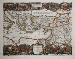
A decorative map showing the eastern Mediterranean and Asia Minor that extends from Rome in the west, Babylon in the east and to Cairo in the south. The eight illustrated cartouches each tell a biblical story. The story begins with the outpouring of the Holy Spirit and the Apostles beginning to spread the Christen faith.
As part of this missionary work, Peter and John healed a lame man, a sinful man collapses at the feet of the Apostles and St. Stephen was stoned. At the bottom right the cartouche shows the episodes of the Apostle Paul. On his way to Damascus he met God, who took his sight. After arriving in Damascus, one of his disciples was cured by the laying of hands on his blindness, whereupon he converted to Christianity. As a missionary, Paul made three trips and they are numbered on the map up to 64. After finishing the third trip, he returned to Jerusalem where he was taken prisoner by Roman guards. He was then taken to Rome for his execution. His voyage is clearly illustrated on the map. The figures above the cartouches hold Christ's cross and the sword he was beheaded with in Rome. The center of the map in the black sea has the title cartouche and a mileage scale above it.
Copper engraving, hand coloured, in very good condition. Dutch text on verso.
Nicolas VISSCHER I (1618 - 1679)
|
For nearly a century the members of the Visscher family were important art dealers and map publishers in Amsterdam. The founder of the business, C. J. Visscher, had premises near to those of Pieter van den Keere and Jodocus Hondius whose pupil he may have been. From about 1620 he designed a number of individual maps, including one of the British Isles, but his first atlas consisted of maps printed from plates bought from van den Keere and issued as they stood with some additions of his own, including historical scenes of battles and sieges for which he had a high reputation. Some maps bear the latinized form of the family name: Piscator. After Visscher's death his son and grandson, both of the same name, issued a considerable number of atlases, constantly revised and brought up to date but most of them lacking an index and with varying contents. The widow of Nicholaes Visscher II carried on the business until it finally passed into the hands of Pieter Schenk.
|