| Reference: | S51192 |
| Author | Jean Baptiste Nicolas Denis d'APRES DE MANNEVILLETTE |
| Year: | 1775 |
| Zone: | Red Sea |
| Printed: | Paris |
| Measures: | 380 x 505 mm |
| Reference: | S51192 |
| Author | Jean Baptiste Nicolas Denis d'APRES DE MANNEVILLETTE |
| Year: | 1775 |
| Zone: | Red Sea |
| Printed: | Paris |
| Measures: | 380 x 505 mm |
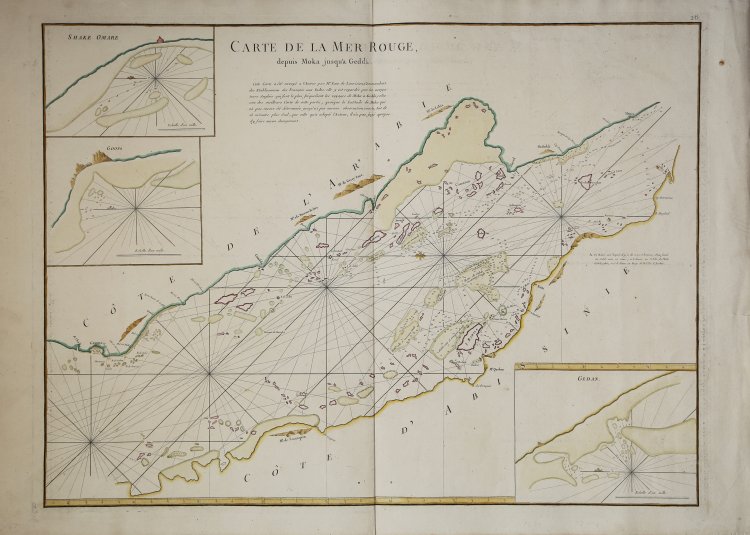
Fine, detailed chart of the southern part of the Red Sea from the expanded second edition of Mannevillette’s influential Neptune Oriental.
It was based on a chart sent to Mannevillette by the imperial official Jean Law de Lauriston.
The chart is east-oriented, with the Arabian Peninsula at the top and the coast of Abyssinia, another name for the Ethiopian Empire, at the bottom. It runs from Jeddah (Gedda), in present-day Saudi Arabia, south to Mocha (Moku), in present-day Yemen. The African coast shown here today is part of Sudan and Eritrea.
The chart includes three insets, Shake Omare and Goofs, both near Jeddah, and Gedan. The only inland details are profiles of high ground that could be spotted from the deck of a ship. The Red Sea, however, is covered in information including rhumb lines, sounding depths, the outlines of sandbars and other navigational obstructions, and descriptions of the bottom quality in various places.
This map was sent to the author by Mr. Law de Laurison, Commandant of the French Establishments in India: it is looked upon there by the English navigators who most frequently travel from Mocha to Jeddah, as one of the best maps of this part; although the latitude of Mocha, which has not yet been determined by any exact observation, is 15 minutes more southerly than that adopted by the author, he has not judged it appropriate to make any change in it.
Baron Jean Law de Lauriston was a colonial official who served in India. He twice served as the Governor General of Pondicherry; indeed, he helped to rebuild the town after it was sacked by the British and then returned to the French in 1765. He also wrote Mémoires sur quelques affaires de l’Empire Mogol 1756-1761 (1767). Law de Lauriston was in a position to meet many sailors in the merchant marine, French and English, contacts which led him to send this map to Mannevillette. The latter was also familiar with the area as an employee of the French East India Company.
Jean Baptiste Nicolas Denis d'APRES DE MANNEVILLETTE (1707 - 1780) 1707 - 1780)
|
Born in Le Havre of a seafaring family d'Apres de Mannevillette had a long and distinguished career as a navigator and one of the first French hydrographers. After studying mathematics in Paris, he gained early experience of the sea in a voyage at the age of nineteen to the Caribbean.
During many subsequent voyages he assembled a collection of material for a projected hydrographic atlas which, with the support of the Academie des Sciences, was published in Paris in 1745 under the title Le Neptune Oriental.
In spite of the popularity of the first issue, it failed to satisfy the author and he spent nearly thirty years, often with the assistance of his friend, Alexander Dalrymple, the English hydrographer, in the preparation of a revised and enlarged edition which eventually was issued in 1775.
|