
| Reference: | VR55FR |
| Author | Pierre DUVAL |
| Year: | 1677 |
| Zone: | Europe |
| Printed: | Paris |
| Measures: | 340 x 470 mm |
| Reference: | VR55FR |
| Author | Pierre DUVAL |
| Year: | 1677 |
| Zone: | Europe |
| Printed: | Paris |
| Measures: | 340 x 470 mm |
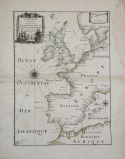
Very handsome chart by a famous 18th century cartographer, Pierre Du Val (1618-1683) shows the North Atlantic Ocean and the coast of western Europe from Scandinavia and Great Britain down to North Africa.
The chart depicts all harbors around the coastlines with no inland detail. The chart includes a rare reference to the Kimmen Line, which indicates a depth of 100 fathoms from Denmark to just west of the Shetland Isles, north of Scotland.
Two compass roses with radiating rhumb lines fill the ocean and the Mediterranean. The decorative title cartouche is ornamented with two fighting ships and is topped with a figurehead and scrolls.
Copperplate with original outline colour, very good condition.
Pierre DUVAL(1618 - 1683)
Pierre DUVAL(1618 - 1683)