| Reference: | VR11OL |
| Author | Pieter GOOS |
| Year: | 1666 |
| Zone: | Europe |
| Printed: | Amsterdam |
| Measures: | 525 x 430 mm |
| Reference: | VR11OL |
| Author | Pieter GOOS |
| Year: | 1666 |
| Zone: | Europe |
| Printed: | Amsterdam |
| Measures: | 525 x 430 mm |
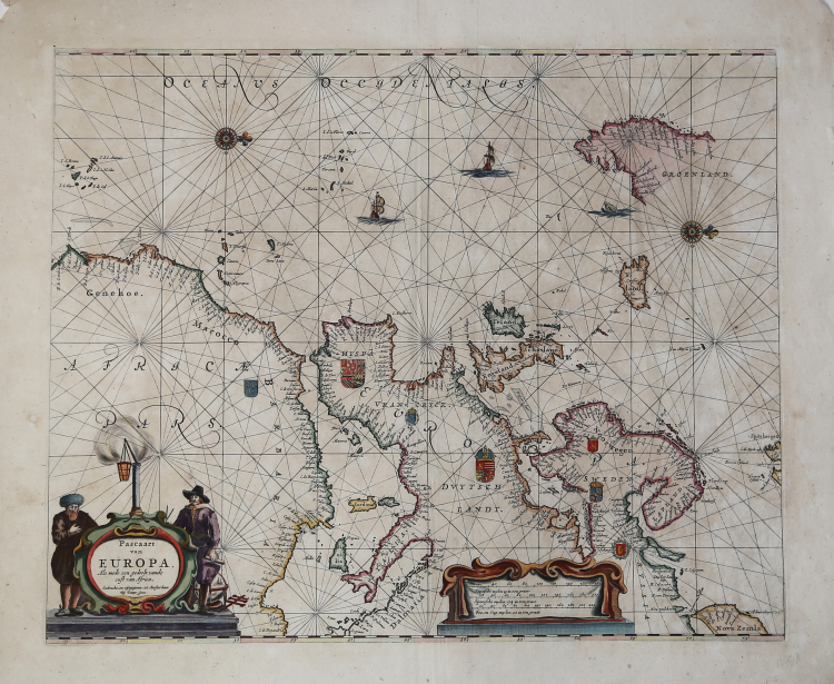
Etching and engraving, 430x525 mm, signed lower left, in the cartouche: Gedruckt, en uytgegeven tot Amsterdam Bij Pieter Goos.
Good proof, printed on contemporary laid paper, contemporary old colouring, in good condition.
Goos' general chart of the Atlantic, Europe and Africa, based upon Blaeu's Paskaert of 1621.
From: De Zee-Atlas, Ofte Water-Weereld, Waer in vertoont werden alle de Zee-Kunsten Van het bekende des Aerd-Bodems. Seer dienstigh voor alle Schippers en Stuurlidienm Als oock voor alle Heeren en Kooplieden. Gesneden, gedruckt en uytgegeven t’ Amsterdam. By Pieter Goos, op de Texelse Kay, naest de Ramskoy, in de Zee-Spiegel, 1666.
Bibliografia: C. Koeman, Atlantes Neerlandici: Bibliography of Terrestrial, Maritime and Celestial Atlases and Pilot Books Published in the Netherlands up to 1880 Vol. IV, Amsterdam 1970, pp. 192-217, Goos 1 A-B (2); Mare Nostrum, a historic voyage across the Mediterranean Sea, Lussemburgo, 2003, p. 23; National Maritime Museum, Catalogue of the Library - Vol. Three, Atlas & Cartography, Londra, 1971, p. 83, n. 92 (n. 2); cfr. R. Shirley, Maps in the Atlases of the British Library, Londra, 2004, pp. 1172-1175.
|
S. Bifolco, "Mare Nostrum, Cartografia nautica a stampa del Mar Mediterraneo" (2020), p. 131, tav. 52.
|
|
Abraham Goos was a noted engraver in Amsterdam who prepared plates for many maps published in well-known atlases of his time including Speed's A Prospect ofthe Most Famous Parts of the World (1627) and the 1632 edition of Speed's Atlas.
He was related to the Hondius family by whom he was also employed as an engraver.
In 1616 he issued a book of maps, the Nieuw Nederlandtsh Caertboeck (4to) which was re-issued in 1619 and 1625.
His son, Pieter, continued and extended his father's business and became one of the group of well-known engravers of sea charts active in Amsterdam in the middle years of the seventeenth century.
In common with Colom, Doncker and Jacobsz he published a pilot guide, the Zee-Spiegel, basing it on plates obtained from Jacobsz. This went through many editions in different languages under the startling titles so popular at the time.
In addition to publishing his Zee-Spiegel in the usual Parts 1 and II (Europe and Atlantic coasts) and Part III (Mediterranean) he broke new ground in preparing Parts IV and V, covering charts and sailing directions for the coasts of the West Indies and West Africa. The later editions of the Zee Atlas were published by his widow who eventually sold the publishing rights of the Atlas and of the Zee-Spiegel to Jacobus Robijn.
|
|
S. Bifolco, "Mare Nostrum, Cartografia nautica a stampa del Mar Mediterraneo" (2020), p. 131, tav. 52.
|
|
Abraham Goos was a noted engraver in Amsterdam who prepared plates for many maps published in well-known atlases of his time including Speed's A Prospect ofthe Most Famous Parts of the World (1627) and the 1632 edition of Speed's Atlas.
He was related to the Hondius family by whom he was also employed as an engraver.
In 1616 he issued a book of maps, the Nieuw Nederlandtsh Caertboeck (4to) which was re-issued in 1619 and 1625.
His son, Pieter, continued and extended his father's business and became one of the group of well-known engravers of sea charts active in Amsterdam in the middle years of the seventeenth century.
In common with Colom, Doncker and Jacobsz he published a pilot guide, the Zee-Spiegel, basing it on plates obtained from Jacobsz. This went through many editions in different languages under the startling titles so popular at the time.
In addition to publishing his Zee-Spiegel in the usual Parts 1 and II (Europe and Atlantic coasts) and Part III (Mediterranean) he broke new ground in preparing Parts IV and V, covering charts and sailing directions for the coasts of the West Indies and West Africa. The later editions of the Zee Atlas were published by his widow who eventually sold the publishing rights of the Atlas and of the Zee-Spiegel to Jacobus Robijn.
|