| Reference: | VR06OL |
| Author | Louis RENARD |
| Year: | 1715 ca. |
| Zone: | Europe |
| Printed: | Amsterdam |
| Measures: | 890 x 715 mm |
| Reference: | VR06OL |
| Author | Louis RENARD |
| Year: | 1715 ca. |
| Zone: | Europe |
| Printed: | Amsterdam |
| Measures: | 890 x 715 mm |
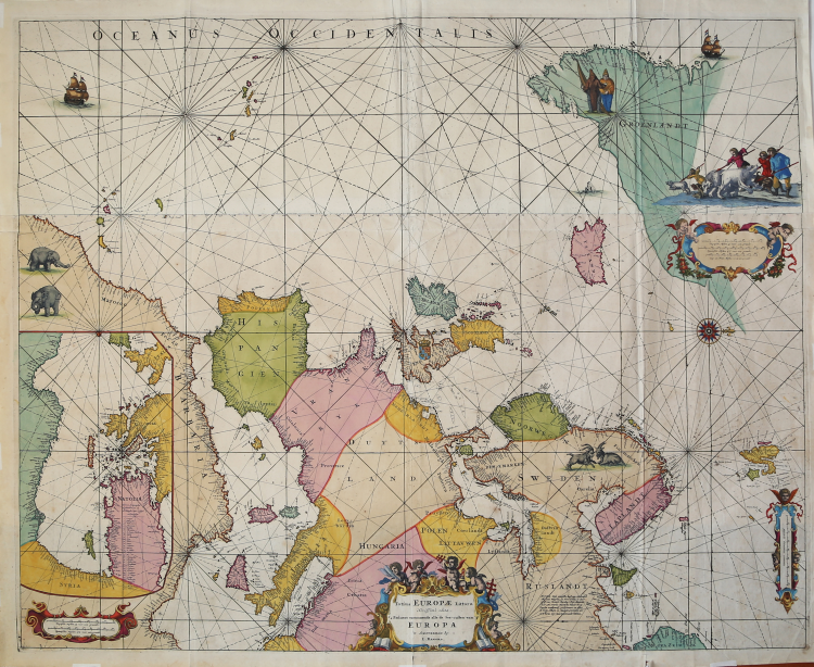
Etching and engraving, 715x890 mm.
Not dated (but 1715), signed in plate in the cartouche, center below: tot Amsterdam, L. Renard
This is a later version of a European sea chart that was originally published in 1675. This version differs in only showing the British crest and showing more detailed political boundaries on the main land. The title cartouche in the center is lavishly surrounded by cherubs and navigational instruments.
The top right contains a mileage scale in Dutch, Spanish and English. The bottom right contains a Germanic miles scale, the bottom left a mileage scale comparing Spanish and Dutch.
At the left edge is an interior map of the coastal area of the Eastern Mediterranean Sea. The European coastline is lined with many place names. Northeast of Iceland is a beautiful compass rose.
Frederick de Wit (1630-1706) was one of the most prolific Dutch cartographers of the second half of the 17th Century. Since 1648 he worked as an engraver in Amsterdam, and was a publisher from 1659. Most of his maps were published as single sheets or shown in published atlases.
From the first edition of the famous nautical atlas by Louis Renard: “Atlas de la Navigation, et du Commerce qui se fait dans toutes les parties du monde. Expliquant par des Cartes & par des Descriptions particulieres de toutes les Cotes & Ports de Mer de l’Univers, la Nature, les Productions, & les Ouvrages ou Manufactures de chaque Pais en particulier: la Religion, le Gouvernement, & la maniere de vivre des Peuples; les Marchandises que I I’on porte d’un Pais a un autre; & celles que l’on rapporte de chaque Pais, I & qui se debitent dans toutes les Parties du Monde pour l’utilite, la magni, ficence, la curiosite, & la nourriture des hornmes, & c. On a marque tres-exactement les Routes, les Isles, les Banes de Sable, les Profondeur des Ports, & generalement tout ce qui regarde la Navigation. Les Cartes et les Descriptions I se succedent tres-ponctuellement les unes aux autres, & accomplissent le tour du Monde, commencant toutes par les Cotes ou chaque Carte precedente a fini. Le tout dresse sur les Memoires les plus recens; Revfi & corrige sur les Nouvelles Observations. A Amsterdam, Chez Louis Renard, Marchand Libraire. M.DCC.XV. Avec Privilege de Nossiegnuers les Etats de Hollande & de Westfrise.”
Bibliografia: Atlases and Cartography, Catalogue of the Library, vol. III (in due parti), Her Majesty Stationery Office, London, 1971, vol. 3, 264; C. Koeman, Atlantes Neerlandici: Bibliography of Terrestrial, Maritime and Celestial Atlases and Pilot Books Published in the Netherlands up to 1880 Vol. IV, Amsterdam 1970, pp. 432-435, Ren 1, (2); Mare Nostrum, a historic voyage across the Mediterranean Sea, Lussemburgo, 2003, p. 25; National Maritime Museum, Catalogue of the Library - Vol. Three, Atlas & Cartography, Londra, 1971, p. 316, n. 264 (2); P. Lee Phillips, A list of Geographical Atlases in the Library of Congress, vol. III, Washington 1914, 559; cfr. R. Shirley, Maps in the Atlases of the British Library, Londra, 2004, pp. 1271-1272.
|
S. Bifolco, "Mare Nostrum, Cartografia nautica a stampa del Mar Mediterraneo" (2020), pp. 172-173, tav. 76.
|
|
Member of a Huguenot family, moved from France to the Netherlands, where since 1703, in Amsterdam, he became a merchant and publisher. Bought many plates by Federico de Wit and in 1715 published his "Atlas de la Navigation et du Commerce".
|
|
S. Bifolco, "Mare Nostrum, Cartografia nautica a stampa del Mar Mediterraneo" (2020), pp. 172-173, tav. 76.
|
|
Member of a Huguenot family, moved from France to the Netherlands, where since 1703, in Amsterdam, he became a merchant and publisher. Bought many plates by Federico de Wit and in 1715 published his "Atlas de la Navigation et du Commerce".
|