| Reference: | VR05OL |
| Author | Frederick de WIT |
| Year: | 1675 |
| Zone: | Europe |
| Printed: | Amsterdam |
| Measures: | 890 x 495 mm |
| Reference: | VR05OL |
| Author | Frederick de WIT |
| Year: | 1675 |
| Zone: | Europe |
| Printed: | Amsterdam |
| Measures: | 890 x 495 mm |
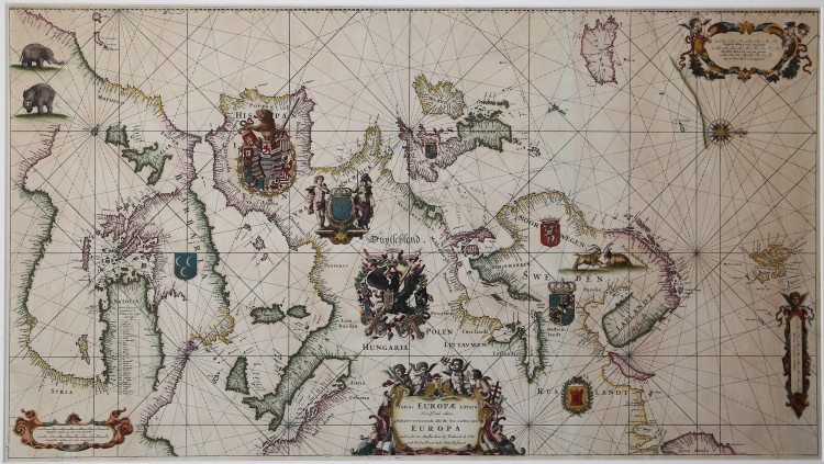
Etching and engraving, 495x890 mm. Without date (but 1675), signed in plate in the cartouche center below: Gedruckt tot Amsterdam by Frederick de Wit in de Kalverstraet in de Witte Pascaert.
Magnificent exampe, with beautiful contemporary old colors, in excellent condition.
This is De Wit’s famous chart of Europe, based on Blaeu’s map from 1621. It shows all the coast of Europe, with the Eastern Mediterranean moved into Africa’s interior, to accommodate it.
A cleverly placed inset in the left of the chart shows also the eastern Mediterranean coast. The coats-of-arms of the major countries are dramatically rendered. The chart appeared in the first edition of De Wit's sea atlas, the Orbis Maritimus.
After the death of De Wit the plates were bought by Louis (Luis) Renard, who issued them with his own text. On the later issues, the coats of arms have been removed. Reiner and Joshua Ottens re-issued Renard’s atlas in 1739 with a French text, and again in 1745 with a Dutch text and their names added to the plates for the first time. Finally, in 1802, the widow of G.Hulst van Keulen, publishedended the long and distinguished career of this plate, and in a way, that of Blaeu’s 1621 map.
Bibliografia: C. Koeman, Atlantes Neerlandici: Bibliography of Terrestrial, Maritime and Celestial Atlases and Pilot Books Published in the Netherlands up to 1880 Vol. IV, Amsterdam 1970, pp. 518-519, M. Wit 1, (4); Mare Nostrum, a historic voyage across the Mediterranean Sea, Lussemburgo, 2003, p. 24; National Maritime Museum, Catalogue of the Library - Vol. Three, Atlas & Cartography, Londra, 1971, pp. 207-208, n. 191 (74).
|
S. Bifolco, "Mare Nostrum, Cartografia nautica a stampa del Mar Mediterraneo" (2020), pp. 138-139, tav. 57.
|
Frederick de WIT (1630 - 1706)
|
De Wit was one of the most prominent and successful map engravers and publishers in Amsterdam in the period following the decline of the Blaeu and Jansson establishments, from which he acquired many copper plates when they were dispersed at auction. His output covered most aspects of map making: sea charts, world atlases, an atlas of the Netherlands, 'town books' covering plans of towns and cities in the Netherlands and Europe, and wall maps. His work, notable for the beauty of the engraving and colouring, was very popular and editions were issued many years after his death by Pieter Mortier and Covens and Mortier.
|
|
S. Bifolco, "Mare Nostrum, Cartografia nautica a stampa del Mar Mediterraneo" (2020), pp. 138-139, tav. 57.
|
Frederick de WIT (1630 - 1706)
|
De Wit was one of the most prominent and successful map engravers and publishers in Amsterdam in the period following the decline of the Blaeu and Jansson establishments, from which he acquired many copper plates when they were dispersed at auction. His output covered most aspects of map making: sea charts, world atlases, an atlas of the Netherlands, 'town books' covering plans of towns and cities in the Netherlands and Europe, and wall maps. His work, notable for the beauty of the engraving and colouring, was very popular and editions were issued many years after his death by Pieter Mortier and Covens and Mortier.
|