| Reference: | S49238.8 |
| Author | Georg BRAUN & Franz HOGENBERG |
| Year: | 1588 |
| Zone: | Rome |
| Printed: | Antwerpen & Cologne |
| Measures: | 495 x 685 mm |
| Reference: | S49238.8 |
| Author | Georg BRAUN & Franz HOGENBERG |
| Year: | 1588 |
| Zone: | Rome |
| Printed: | Antwerpen & Cologne |
| Measures: | 495 x 685 mm |
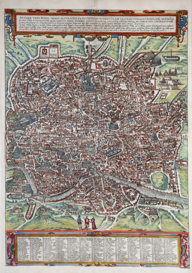
A good example, with fine original colour, of the Braun & Hogenberg Plan of Rome, first published in the 1588 edition of the Civitates Orbis Terrarum.
Braun & Hogenberg's view is based upon the work of Pirro Ligorio. However, the title banner and lower key embellishments are completely revised, the former lacking the strapwork used by Braun & Hogenberg and replaced with a tapestry style fringe, while the lower key is now embellished with images of two nobles.
Rome is shown from the west in a bird's-eye view that was a major achievement in its day. It includes the most important buildings from antiquity, several aqueducts, the Aurelian Wall and large arterial streets. The three figures in Roman garb in the foreground underscore the aim of meticulous reconstruction.
Mont Testaccio is shown on the far side of the Tiber in the lower right-hand edge of the picture, with the Pyramid of Cestius above it to the right. At the center of the illustration the Marcellus Theatre can be identified above the island in the Tiber, with the vast Circus Maximus, used for chariot races, just above it to the right. Above that is the Palatine represented with intricately detailed buildings, an indication of the confusion at the time about how the seat of imperial power actually looked.
To the north the Coliseum flanks the Palatine. In the lower left-hand part of the picture field is the Campus Martius, with the stadium of Domitian at the center, site of the modern Piazza Navona. Slightly higher up is the Pantheon with its monumental dome, looking as it does today. On the lower left edge the two great imperial mausoleums are shown as they would have appeared during the Roman epoch. Above the mausoleum of Augustus and below, at the bend in the river, is that of Hadrian.
In the lower left-hand corner, the Mons Vaticanus with the Circus built by Caligua and a Neronian palace are recognizable outside the city. The baths of Diocletan dominate the northeastern part of the city. The Castra Praetoria, the barracks of the Praetorian Guard, is shown below the city walls in the upper left-hand corner.
The work is included in the Civitates Orbis Terrarum, the first atlas devoted exclusively to plans and views of the world's major cities. Printed in six volumes between 1572 and 1617 it was so successful and widespread that several editions translated into Latin, German and French were printed.
The first volume of the Civitates Orbis Terrarum was published in Cologne in 1572. The sixth and the final volume appeared in 1617. This great city atlas, edited by Georg Braun and largely engraved by Franz Hogenberg, eventually contained 546 prospects, bird-eye views and map views of cities from all over the world. Fransz Hogenberg produced the plates for the first four books, and Simon van den Neuwel (Novellanus, active since 1580) those for volumes V and VI.
Georg Braun (1541-1622), a cleric of Cologne, was the principal editor of the work, and was greatly assisted in his project by the close, and continued interest of Abraham Ortelius, whose Theatrum Orbis Terrarum of 1570 was, as a systematic and comprehensive collection of maps of uniform style, the first true atlas. The Civitates, indeed, was intended as a companion for the Theatrum, as indicated by the similarity in the titles and by contemporary references regarding the complementary nature of two works. Nevertheless, the Civitates was designs to be more popular in approach, no doubt because the novelty of a collection of city plans and views represented a more hazardous commercial undertaking than a world atlas, for which there had been a number of successful precedents. Franz Hogenberg (1535-1590) was the son of a Munich engraves who settled in Malines. He engraved most of the plates for Ortelius's Theatrum and the majority of those in the Civitates, and may have been responsible for originating the project.
Over a hundred of different artists and cartographers, the most significant of whom was Antwerp artist Georg Hoefnagel (1542-1600), engraved the cooper-plates of the Civitates from drawings. He not only contributed most of the original material for the Spanish and Italian towns but also reworked and modified those of other contributors. After Hoefnagel's death his son Jakob continued the work for the Civitates.
The author set out to depict "non icones et typi urbium," that is, not generic and typified images, "sed urbes ipsae admirabili caelaturae artificio, spectantium oculis subiectae appareant": not intended to allude or idealize but to represent faithfully on paper, to reproduce exactly, and in real time, what the eye sees, as announced in the preface to the first volume of Civitates Orbis Terrarum.
Copperplate with fine later hand colour, very good condition.
|
Fauser, A. 11932; Huelsen (1915) n. 38; Caldana, Roma Antica, p. 84, n. I.17.
|
|
George Braun (1541-1622), cleric of Cologne, was the principal editor of the Civitates Orbis Terrarum, and was greatly assisted in his project by the close, and continued interest of Abraham Ortelius, whose Theatrum Orbis Terrarum of 1570 was, as a systematic and comprehensive collection of maps of uniform style, the first true atlas.
Franz Hogenberg (1535-1590) was the son of a Munich engraves who settled in Malines. He engraved most of the plates for Ortelius's Theatrum and the majority of those in the Civitates, and may have been responsible for originating the project.
|
|
Fauser, A. 11932; Huelsen (1915) n. 38; Caldana, Roma Antica, p. 84, n. I.17.
|
|
George Braun (1541-1622), cleric of Cologne, was the principal editor of the Civitates Orbis Terrarum, and was greatly assisted in his project by the close, and continued interest of Abraham Ortelius, whose Theatrum Orbis Terrarum of 1570 was, as a systematic and comprehensive collection of maps of uniform style, the first true atlas.
Franz Hogenberg (1535-1590) was the son of a Munich engraves who settled in Malines. He engraved most of the plates for Ortelius's Theatrum and the majority of those in the Civitates, and may have been responsible for originating the project.
|