| Reference: | S35559 |
| Author | Pieter VANDER AA |
| Year: | 1720 ca. |
| Zone: | Valletta |
| Printed: | Leyden |
| Measures: | 365 x 285 mm |
| Reference: | S35559 |
| Author | Pieter VANDER AA |
| Year: | 1720 ca. |
| Zone: | Valletta |
| Printed: | Leyden |
| Measures: | 365 x 285 mm |
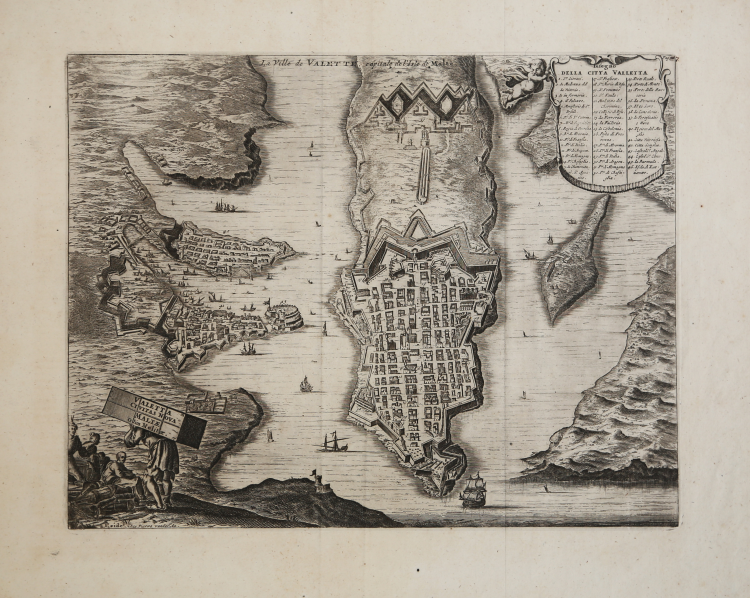
A dynamic bird's-eye view of Valletta, the capital city of Malta, published circa 1720.
Seen from the northwest, the city is richly detailed, although likely arranged more geometrically than in reality. Surrounding cities of Senglea and Vittoriosa, as well as Fort Ricasoli, are also shown to the left of the capital. A figured title cartouche in the lower left shows a group of men, one carrying a trunk on his back bearing the title.
The surrounding waters are filled with decorative ships, and a French coat of arms is drawn in the upper left corner to indicate France's colonial control of the region.
A key in the upper right identifies 46 principal spots in the town. The map is in very good condition with overall toning and no chips or tears. Original uncolored engraving with narrow margins as issued.
Published by Pieter Van der Aa, was also parte of the Dapper's travel. Olfert Dapper (c. 1635 - 1689) was a Dutch physician and writer. His work was especially valued then and now for its precise style of engraving, of which this map of Valletta is a beautiful example.
Pieter VANDER AA (1659 - 1733)
|
Records show that van der Aa, born in Leyden in 1659, made an early start in life by being apprenticed to a bookseller at the age of nine and starting on his own in business as a book publisher by the time he was twenty-three.
During the following fifty years he published an enormous amount of material, including atlases and illustrated works in every shape and size, two of them consisting of no less than 27 and 28 volumes containing over 3,000 maps and plates.
Most of his maps were not of the first quality and were certainly not original, but they are often very decorative and are collected on that account.
|