| Reference: | s30702 |
| Author | Pieter VANDER AA |
| Year: | 1720 ca. |
| Zone: | Central Italy |
| Printed: | Leyden |
| Measures: | 455 x 355 mm |
| Reference: | s30702 |
| Author | Pieter VANDER AA |
| Year: | 1720 ca. |
| Zone: | Central Italy |
| Printed: | Leyden |
| Measures: | 455 x 355 mm |
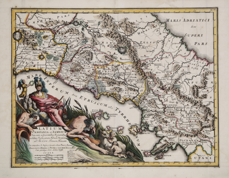
Map of central Italy in Roman times, according to information provided by the historian Titus Livius. The territory is bordered to the north by Lake Bracciano, to the east by the Sannio area, and to the south by ancient Picentia - today Pontecagnano - in Campania.
Map taken from the 'Thesaurus Antiquitatum et Historiarum Italiae, Neapolis, Siciliae Sardiniaae, Corsicae and Melitae', a monumental work by Georgius Graevius published in the first quarter of the 18th century.
Between 1704 and 1725, the 45 volumes of the 'Thesaurus antiquitatum' were printed in Leiden, a complex, laborious generation, extolled by some as extraordinary, criticised, on the other hand, by others, who spoke of it as an 'énorme compilation sans choix e sans ordre'. A project that greatly concerned contemporaries, in Italy, but which interested little historiography afterwards which, except in rare cases, underlined its merely erudite character and substantial uselessness.
Graevius' work is nevertheless enriched by the precious plates signed by Dutch publisher Pieter Vander AA.
Copper engraving, finely hand-colouring, in good condition.
Pieter VANDER AA (1659 - 1733)
|
Records show that van der Aa, born in Leyden in 1659, made an early start in life by being apprenticed to a bookseller at the age of nine and starting on his own in business as a book publisher by the time he was twenty-three.
During the following fifty years he published an enormous amount of material, including atlases and illustrated works in every shape and size, two of them consisting of no less than 27 and 28 volumes containing over 3,000 maps and plates.
Most of his maps were not of the first quality and were certainly not original, but they are often very decorative and are collected on that account.
|