
| Reference: | MS6905 |
| Author | Johannes VAN KEULEN |
| Year: | 1682 ca. |
| Zone: | Adriatic Sea |
| Printed: | Amsterdam |
| Measures: | 595 x 515 mm |
| Reference: | MS6905 |
| Author | Johannes VAN KEULEN |
| Year: | 1682 ca. |
| Zone: | Adriatic Sea |
| Printed: | Amsterdam |
| Measures: | 595 x 515 mm |
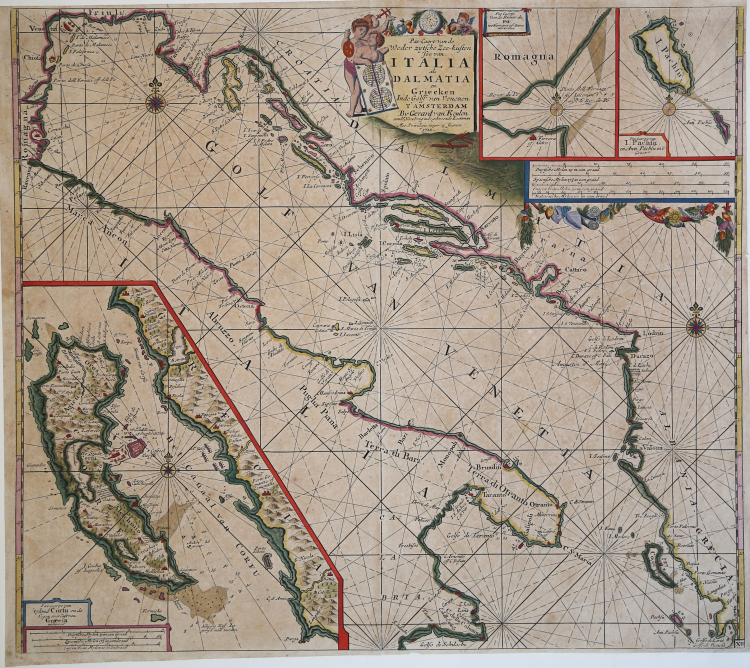
Sea chart published for the first time in the Zee-Fakel of Van Keulen, in 1682, and afterwards included in different editions of the sea atlas, published until 1720. The chart depicts the Adriatic sea, from the gulf og Venice until Capo Santa Maria di Leuca, the Dalmatian and the Albanese coasts, until the Greek ones, the gulf of Taranto with the Jonio sea until Capo delle Colonne. The map includes a large inset of Corfu and smaller inset of the mouth of the Po River and Paxos & Andipaxos islands. The chart is embellished with five compass roses, rhumb lines, and a decorative title cartouche featuring putti.
The plate is reprinted and included in numerous editions, also in other languages, of the atlas
Starting from 1695, it’s also included in the other nautical guide of the editors of Amsterdam, the De Groote Nieuwe Vermeerderde Zee-Atlas ofte Water-werelt (see Koeman, AN, vol. IV, p. 293, Keu 20 B).
The Van Keulen dynasty of publishers, printers, booksellers, and cartographers produced the most comprehensive and up-to-date Dutch nautical atlases. Johannes van Keulen (1654–1715) founded a book and instrument business in Amsterdam in 1678 and in 1680 obtained the privilege of printing nautical guides and atlases from Holland and West Friesland. His first major work was the Nieuwe Lichtende Zee-Fakkel, illustrated by Jan Luyken, with maps drawn by Claes Jansz Vooght; five volumes were published between 1681 and 1684. Van Keulen also produced a Zee-Atlas ofte Water-werelt. The Van Keulen family continued to operate for nearly two centuries; Gerard (1678 - 1726) produced new editions of his father's works, numerous manuscript maps, and was appointed hydrographer to the Dutch East India Company (VOC) in 1706; his son Jan II van Keulen (1704 - 1770) took over the business in 1726 and published a new edition of the Asiatic volume of the Zee-Atlas; he was appointed cartographer to the VOC in 1743. After Jan II's death, his sons Cornelis Buijs and Gerard Hulst van Keulen ran the family business. Gerard (1733 - 1801) added a further volume to the Zee-Fakkel containing East India material derived from the VOC. Gerard, in addition to publishing the first nautical almanac in Dutch in 1788, was one of the three original members of the commission established by the Dutch government in 1787 to solve the problem of finding longitude at sea. Gerard's son, Jan III, was the last van Keulen to run the company.
Etching and engraving, beautiful example in old coloring.
Bibliografia
C. Koeman, Atlantes Neerlandici: Bibliography of Terrestrial, Maritime and Celestial Atlases and Pilot Books Published in the Netherlands up to 1880 Vol. IV, Amsterdam 1970, pp. 338-347, Keu 87 A (1) 99; National Maritime Museum, Catalogue of the Library - Vol. Three, Atlas & Cartography, Londra, 1971, pp. 110-114, n. 107 (104); cfr. R. Shirley, Maps in the Atlases of the British Library, Londra, 2004, pp. 1200-1213; cfr. D. de Vries, G. Schilder, W. Morzer Bruyns, P. van Iterson, I. Jacobs, The Van Keulen Cartography Amsterdam 1680-1885, Alphen aan den Rijn, 2005
|
Zacharakis #1182.
|
Johannes VAN KEULEN (1654 - 1715)
|
The Van Keulen dynasty of publishers, printers, booksellers, and cartographers produced the most comprehensive and up-to-date Dutch nautical atlases. Johannes van Keulen (1654–1715) founded a book and instrument business in Amsterdam in 1678 and in 1680 obtained the privilege of printing nautical guides and atlases from Holland and West Friesland. His first major work was the Nieuwe Lichtende Zee-Fakkel, illustrated by Jan Luyken, with maps drawn by Claes Jansz Vooght; five volumes were published between 1681 and 1684. Van Keulen also produced a Zee-Atlas ofte Water-werelt. The Van Keulen family continued to operate for nearly two centuries; Gerard (1678 - 1726) produced new editions of his father's works, numerous manuscript maps, and was appointed hydrographer to the Dutch East India Company (VOC) in 1706; his son Jan II van Keulen (1704 - 1770) took over the business in 1726 and published a new edition of the Asiatic volume of the Zee-Atlas; he was appointed cartographer to the VOC in 1743. After Jan II's death, his sons Cornelis Buijs and Gerard Hulst van Keulen ran the family business. Gerard (1733 - 1801) added a further volume to the Zee-Fakkel containing East India material derived from the VOC. Gerard, in addition to publishing the first nautical almanac in Dutch in 1788, was one of the three original members of the commission established by the Dutch government in 1787 to solve the problem of finding longitude at sea. Gerard's son, Jan III, was the last van Keulen to run the company.
|
|
Zacharakis #1182.
|
Johannes VAN KEULEN (1654 - 1715)
|
The Van Keulen dynasty of publishers, printers, booksellers, and cartographers produced the most comprehensive and up-to-date Dutch nautical atlases. Johannes van Keulen (1654–1715) founded a book and instrument business in Amsterdam in 1678 and in 1680 obtained the privilege of printing nautical guides and atlases from Holland and West Friesland. His first major work was the Nieuwe Lichtende Zee-Fakkel, illustrated by Jan Luyken, with maps drawn by Claes Jansz Vooght; five volumes were published between 1681 and 1684. Van Keulen also produced a Zee-Atlas ofte Water-werelt. The Van Keulen family continued to operate for nearly two centuries; Gerard (1678 - 1726) produced new editions of his father's works, numerous manuscript maps, and was appointed hydrographer to the Dutch East India Company (VOC) in 1706; his son Jan II van Keulen (1704 - 1770) took over the business in 1726 and published a new edition of the Asiatic volume of the Zee-Atlas; he was appointed cartographer to the VOC in 1743. After Jan II's death, his sons Cornelis Buijs and Gerard Hulst van Keulen ran the family business. Gerard (1733 - 1801) added a further volume to the Zee-Fakkel containing East India material derived from the VOC. Gerard, in addition to publishing the first nautical almanac in Dutch in 1788, was one of the three original members of the commission established by the Dutch government in 1787 to solve the problem of finding longitude at sea. Gerard's son, Jan III, was the last van Keulen to run the company.
|