
| Reference: | s48885 |
| Author | Frederick de WIT |
| Year: | 1670 ca. |
| Zone: | Italy |
| Printed: | Amsterdam |
| Measures: | 550 x 445 mm |
| Reference: | s48885 |
| Author | Frederick de WIT |
| Year: | 1670 ca. |
| Zone: | Italy |
| Printed: | Amsterdam |
| Measures: | 550 x 445 mm |
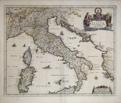
A very rare map of the peninsula by Frederick de Wit, published in Amsterdam around 1670.
Although it is based on the cartography of Giovanni Antonio Magini, it seems more likely derived from the map published by Johannes Blaeu in his Atlas Maior, sive cosmografphiae Blaviana, qua solum, salum, coelum, accussimae describuntur, Amstelaedami, labore e sumpitubus Joannis Blaeu of 1662.
Conic projection, central meridian 36°, bird's eye view. This map is notable for the relative accuracy of its coastline. The title is contained in an artistic frieze with watercolor and gold figures. At the bottom right, a dual scale: in Italian miles and common German miles.
Frederick de Wit (c. 1630–1706) was a cartographer and publisher, originally from Gouda. He moved to Amsterdam in 1648, studying under the Blaeu family, and in 1654 he began his own business, opening a printing shop under the name “The Three Crabs,” which he later changed to “The White Chart.” In 1660 he published his world map, Nova Totius Terrarum Orbis Tabula, produced both as a wall map and as a folio atlas (see Shirley, The Mapping of the World, no. 444). Two years later he began printing atlases, assembled primarily to order, some of which included over 150 maps. After marrying Maria van der Way, a native of Amsterdam, de Wit obtained citizen privileges and became a member of the city guild of St. Luke in 1664. In 1675 he published his sumptuous nautical atlas, Orbis Maritimus ofte Zee Atlas, also known for its elaborate decoration. In 1695, he published a book of city views in the Netherlands, "Perfect Views of the Seventeenth Nederlandse Province." After de Wit's death, his widow, Maria, continued the business until 1710. Their son, Franciscus, was a fish merchant and had no interest in the map business. The printing shop was then sold at auction, and most of the plates were purchased by Pieter Mortier.
Etching with beautiful contemporary coloring, in excellent condition.
Frederick de WIT (1630 - 1706)
|
De Wit was one of the most prominent and successful map engravers and publishers in Amsterdam in the period following the decline of the Blaeu and Jansson establishments, from which he acquired many copper plates when they were dispersed at auction. His output covered most aspects of map making: sea charts, world atlases, an atlas of the Netherlands, 'town books' covering plans of towns and cities in the Netherlands and Europe, and wall maps. His work, notable for the beauty of the engraving and colouring, was very popular and editions were issued many years after his death by Pieter Mortier and Covens and Mortier.
|