
| Reference: | S48051 |
| Author | Daniel Friedrich Sotzmann |
| Year: | 1796 |
| Zone: | Italy |
| Printed: | London |
| Measures: | 440 x 405 mm |
| Reference: | S48051 |
| Author | Daniel Friedrich Sotzmann |
| Year: | 1796 |
| Zone: | Italy |
| Printed: | London |
| Measures: | 440 x 405 mm |
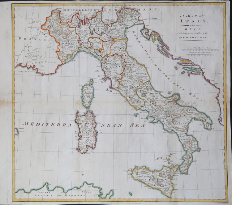
Rara carta della penisola incisa da S. J. Neele per la tipografia di George Robinson, stampa a Londra nel 1796.
La carta è compilata dal cartografo tedesco Daniel Friedrich Sotzmann e segue il modello introdotto da G. de L’Isle all’inizio del’700.
Sotzmann (13 aprile 1754 - 3 agosto 1840) è stato un geografo, geometra, disegnatore e cartografo commerciale tedesco attivo a Berlino tra la fine del XVIII e l'inizio del XIX secolo. È considerato il padre della cartografia commerciale berlinese. Pubblicò il suo primo atlante nel 1795-96. In seguito, assunse un incarico presso il Reale Ufficio Statistico Prussiano e, dopo il 1816, presso il Servizio Statale Prussiano.
Acquaforte, finemente colorata a mano, in ottimo stato di conservazione.
Daniel Friedrich Sotzmann (13. April 1754, Spandau - 3. August 1840, Berlin)
|
Daniel Friedrich Sotzmann (April 13, 1754 - August 3, 1840) was a German geographer, surveyor, draftsman, and commercial cartographer active in Berlin during the late 18th and early 19th centuries. He is considered the father of Berlin commercial cartography. Sotzmann was born in Spandau, the son of a pewterer. He studied engineering in Spandau and taught himself surveying. From 1772 – 1773 he worked as a draftsman, making maps under the direction of the cartographer Carl Ludwig Oesfeld (1741 - 1804). Afterwards he became a civilian conductor at the Kgl. Immediate Construction Commission in Potsdam, a position which he held until 1778. In 1778 he took a position in Berlin as an official in the General Tobacco Administration under Minister Count von der Schulenburg-Kehnert. Around this time, he mastered engraving and in 1783 issued his first maps, among them a plan of Gdansk and an early map of Post-Revolutionary War United States. This began an intense period of map publishing. In 1786, at 32, he joined the Prussian Royal Academy of Sciences, succeeding Johann Christoph Rhode as the that organization's official geographer. He made his first globe in 1791 as a counterpart to Johann Elert Bode's (1747 - 1826) famous celestial globe. He issued his first atlas in 1795-96. Later he took a position with the Royal Prussian Statistical Bureau and after 1816, then Prussian State Survey. Like many engravers of the period, his eyesight began to go bad, forcing him to retire by 1825. In all, Sotzmann was one of the most important German cartographers in his time . He developed trend-setting representations for small-scale cartography. Through Sotzmann's connections to state and scientific agencies, his publications in terms of reliability, wealth of information, and accuracy surpassed all other contemporary Prussia publications. In addition, he produced several seminal cartographic works focusing on the Americas and in particular the United States. Sotzmann was survived by a son, Johann Daniel Ferdinand and daughter, Johanna Philippine. He died of old age in 1840.
|