
| Reference: | CO-347 |
| Author | Jodocus HONDIUS Jr. |
| Year: | 1648 |
| Zone: | Italy |
| Printed: | Amsterdam |
| Measures: | 205 x 150 mm |
| Reference: | CO-347 |
| Author | Jodocus HONDIUS Jr. |
| Year: | 1648 |
| Zone: | Italy |
| Printed: | Amsterdam |
| Measures: | 205 x 150 mm |
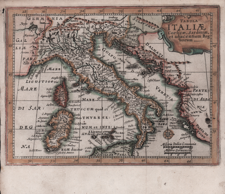
Bella carta geografica dell’Italia tratta dall’Atlas Minor pubblicato ad Amsterdam nel 1648 presso Jannsonius. Nel 1607 Jodocus Hondius pubblica per la prima volta una versione tascabile dell’Atlas di G. Mercator nominandolo appunto Atlas Minor. Le mappe si basano in parte sul lavoro Mercatoriano del 1580-90 e in parte sulle mappe dello stesso Hondius pubblicate nel 1606. L’enorme popolarità del formato ridotto e il prezzo inferiore rispetto agli atlanti in folio si riflettè in un enorme successo editoriale e alla pubblicazione di continui aggiornamenti ed arricchimenti. Circa 20 anni dopo Joannes Janssonius commissiona una nuova serie di carte geografiche incise da Pieter Van Den Keere (Kaerius) e Abraham Goos due fra i più validi incisori olandesi dell’epoca. Queste eleganti carte sorprendono, data la ridotta dimensione, per la ricchezza del dettaglio a livello decorativo (cartigli, navi, rose dei venti ecc..) e per la precisione cartografica nei rilievi. Koeman “Atlantes Neerlandici” Me203.
Acquaforte, finemente colorata a mano, in ottimo stato di conservazione.
Jodocus HONDIUS Jr. (Amsterdam 1594 -1629)
|
Jodocus Hondius Jr. was born in 1593, and his earliest signed publication was a map of Scandinavia, issued in 1613. Son of Jodocus Hondius (1563-1612) - engraver, cartographer, printer and publisher – founder of the Hondius typography, that was one of the most important of the time, even thanks to the collection of Mercator’s plates and the pubblication of many charts and atlases. In 1604, Hondius bought the copperplates of Mercator’s Atlas at the auction of Gerard Jr.’s effects. He added another forty maps, including new maps of the Continents and important regional maps of the Americas, before publishing a new edition of the Atlas, in 1606, in competition with Ortelius’ Theatrum. As many of the maps were more up-to-date, the Mercator-Hondius Atlas effectively superseded Ortelius’ Theatrum. On his death in 1612 his widow, Coletta van den Keere continued the business with his two childs; Jodocus Jr. and Hendrick (1597-1651) took over. In June 1621, Jodocus Jr. married Anne Staffmaecker, and moved into a shop on the Dam, where he established his own publishing business. From the period 1621 onwards, Jodocus Jr. published a small number of maps, including several "figured border" maps, including maps of the four continents, the British Isles and Brabant. In 1618 Jodocus Jr. published the important map "Nova Virginiae Tabula", engraved by Dirk Grijp, being the first and most important derivative of John Smith's map of Virginia originally published in 1612. (Burden, America, 193). Other engravers who worked for Hondius are Abraham Goos, Salomon Rogiers, Evert Sijmonsz van Hamersveldt. Very little is known about the cooperation between the Hondius' brothers and their brother-in-law. Aside from the partnership in the continuation of Jodocus Sr's workshop (1612), it seems all three successively started their own businnes. However, from the map of Orange of 1627, it appears that a cooperation certainly extended as far as that year, as the map has a dedication by Jud. et Henr. Hondius to Frederick Henry. According to Peter van the Krogt (cf. Atlantes Neerlandici) Jodocus Hondius Jr. and his younger brother Henricus Hondius where competitors.
|