
| Reference: | S37866 |
| Author | Abraham ORTELIUS |
| Year: | 1598 |
| Zone: | Italy |
| Printed: | Antwerpen |
| Measures: | 500 x 352 mm |
| Reference: | S37866 |
| Author | Abraham ORTELIUS |
| Year: | 1598 |
| Zone: | Italy |
| Printed: | Antwerpen |
| Measures: | 500 x 352 mm |
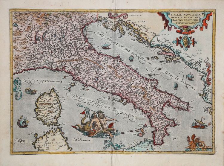
Second version of Abraham Ortelius's Italia Novissima, with the two goods in the sea only placed side by side after censorship.
This general map of Italy is based, as indicated in the title cartouche, on the work of Giacomo Gastaldi, specifically Il disegno della geografia moderna de tutta la provincia de la Italia, published by Gastaldi in 1561. Other maps of Italy cited in Ortelius's "Catalogus Auctorum" are those by Benedetto Bordone and Giovanni Andrea Vavassori.
Compared to Gastaldi's model, Ortelius inserted decorative elements; however, these too are not original, but rather taken from the collections of ornaments and printed cartouches by Hans Vriedeman De Vries (from which the title cartouche and the seated sphinx on the graphic scale of this map are taken), Frans Floris, and Benedetto Battini, all published in Antwerp between approximately 1550 and 1560.
The title correctly cites the source used to outline this map of Italy, that of the “Pedemontano” Iacopo (Giacomo) Gastaldi, who created a work of fundamental importance, capable of imposing itself on previous models, replacing them and becoming the most followed and cartographically advanced expression until the work of Giovanni Antonio Magini in 1608. Ortelius translates the map with his own personal graphic design, consisting of cities with castles with the names in Italic characters; of mountains with rounded mole cones; of the cartouche made with curved geometric shapes; of the cardinal points written in wavy ribbons; of the numerous decorative elements among which the siren above the Italic mile scale stands out and above all the two figures in the middle of the Tyrrhenian Sea (Neptune intent on flirting with a sea nymph, plausibly Thoosa). Their attitude sparked censorship, if it is true that starting from the 1584 edition, Ortelius produced a second version of his Italia Novissima, having a new plate engraved, in which they were placed only side by side, with Neptune encircling Thoosa's waist.
Example taken from the 1598 French edition of the Theatrum Orbis Terrarum. Van den Broecke: “Replaces plate Ort 117 from 1584L onwards. However, we found a copy of the early plate Ort 117 belonging to an edition as late as the 1609/1612S one. The early plate Ort 117 has "SERVIA" in the upper right corner, this late plate does not”.
The Theatrum is considered the first true modern “Atlas”. The work was published in 7 languages and 36 editions, for which - in 1570 - Ortelius obtained the privilege, a kind of copyright that prevented other cartographers from publishing his works. The Theatrum represented the most advanced work of cartographic description. Ortelius collected in it the geographical and cartographic knowledge of his time, proposing in 147 spectacular engraved plates the most faithful image of the world then known and, in some extraordinary "historical maps", regions and routes taken from literature, mythology, tradition. Ortelius was also the first to cite sources, mentioning the names of cartographers in the "catalogus auctorum". From 1598 to 1612 the posthumous editions of the Theatrum were made by his collaborator Johannes Baptiste Vrients.
Etching, magnificent contemporary coloring, in perfect condition.
Bibliografia
Borri, L’Italia nell’antica cartografia, 44; Van den Broecke 118; Karrow 30/90, p. 216-249, Meurer p. 148-154.
Abraham ORTELIUS (1528 - 1598)
|
Abraham Ortel, better known as Ortelius, was born in Antwerp and after studying Greek, Latin and mathematics set up his business there with his sister, as a book dealer and 'painter of maps'. Travelling widely, especially to the great book fairs, his business prospered and he established contacts with many sultured men in many lands. On one such visit to England, possibly seeking temporary refuge from religious persecution, he met William Camden whom he is said to have encouraged in the production of the Britannia.
A turning-point in his career was reached in 1564 with the publication of a World Map in eight sheets of which only one copy is known: other individual maps followed and then - at the suggestion of a friend - he gathered together a collection of maps from contacts among European cartographers and had them engraved in uniform size and issued in 1570 as the Theatrum Orbis Terrarum (Atlas of the Whole World). Although Lafreri and others in Italy had published collections of 'modern' maps in book form in earlier years, the Theatrum was the first uniformly sized, systematic collection of maps and hence can be called the first atlas, although that term itself was not used until twenty years later by Mercator.
The Theatrum, with most of its maps elegantly engraved by Frans Hogenberg, was an instant success and appeared in numerous editions in different languages including addenda issued from time to time incorporating the latest contemporary knowledge and discoveries. The final edition appeared in 1612. Unlike many of his contemporaries Ortelius noted his sources of information and in the first edition acknowledgement was made to eighty-seven different cartographers.
Apart from the modern maps in his major atlas, Ortelius himself compiled a series of historical maps known as the Parergon Theatri which appeared from 1579 onwards, sometimes as a separate publication and sometimes incorporated in the Theatrum.
1570 Theatrum Orbis Terrarum 1570-1612 Between these years the Theatrum was re-issued in 42 editions with 5 supplements with text in Latin, Dutch, German, French, Spanish, Italian and English. The English edition was published in 1606 by John Norton, the maps being printed in Antwerp and the text added in London. Three years later Ortelius died in 1598, his heirs transferred publication rights to Jan Baptiste Vrients who produced the posthumous editions until he died in 1612
1577-85 Spiegel der Werelt (8vo) Maps from the Theatrum, reduced in size, engraved by Philip Galle: text by Pieter Heyns. 6 editions with Dutch, French and Latin text. 1588-i 603 Epitome theatri orbis terrarum (12mo/8v0) 11 further editions of the smaller maps with an increasing number of maps with text also in Italian and English (1603). i6oi-i 2 7 further editions with improved engravings by Arsenius Brothers: text by Michel Coignet in Latin, French, German, Italian and English (1603). 1598-1724 Theatro del Mondo (4t0/12mo/24mo) 8 editions with Italian text; plates engraved in Italy.
1579-1606 Parergon Theatri The number of maps included in the Parergon increased from 4 in 1579 to 43 in 1606 with text in Latin, French, Italian, German and English (1606) 1624 Re-issued in Antwerp as a separate publication by Balthasar Moretus. This edition included a reproduction of the Peutinger table.
|