| Reference: | S34927 |
| Author | Franciscus HALMA |
| Year: | 1717 |
| Zone: | Holy Land |
| Printed: | Amsterdam |
| Measures: | 1132 x 387 mm |
| Reference: | S34927 |
| Author | Franciscus HALMA |
| Year: | 1717 |
| Zone: | Holy Land |
| Printed: | Amsterdam |
| Measures: | 1132 x 387 mm |
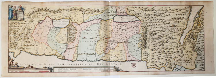
Uncommon map of Holy Land showing the wandering of the Children Israel's with the 42 encampments, published by Francois Halma and realized
Oriented with north at top left and divided into tribes with a key at bottom. The title cartouche includes Moses, Aaron and a Roman soldier.
Copperplate with fine later hand colour, very good condition.
Franciscus HALMA (1653 - 1722)
|
A book publisher who started business in Utrecht and later moved to Amsterdam and finally settled in Leeuwarden .Included in his prolific output of historical and theological work were issues of the atlases detailed below.
1695 Ptolemy’s Geographia
re-issues at Utrecht of Mercator’s 1578 edition : further issues1698(Franeker)
1704 (Utrecht)
(See also Appendix A.)
1704 Geographia Sacra
c. 1705-09 Description de tout l’Univers
1718 Atlas of Friesland
re-issue of work by Schotanus van Sterringa (1698)
|