
| Reference: | S4983 |
| Author | J. TIRINUS |
| Year: | 1632 ca. |
| Zone: | The Holy Land |
| Printed: | Amsterdam |
| Measures: | 800 x 310 mm |
| Reference: | S4983 |
| Author | J. TIRINUS |
| Year: | 1632 ca. |
| Zone: | The Holy Land |
| Printed: | Amsterdam |
| Measures: | 800 x 310 mm |
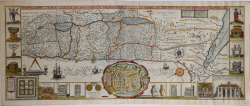
Large attractive plan of the Holy Land in east orientation.
Map depicts from Syria and Tyre southward as far as the Sinai, Egypt and Thebes.
First published in Antwerp 1632. Centered a city plan of Jerusalem after Villalpando 'Hierosolymae Veteris Imago'. Surrounded with 18 illustrationes showing the temple and its instruments.
Two prints joint, fine colouring, new margins, otherways in good conditions.
J. TIRINUS
J. TIRINUS