
| Reference: | D01 |
| Author | Charles William Meredith Van de Velde |
| Year: | 1866 |
| Zone: | The Holy Land |
| Measures: | 840 x 1320 mm |
| Reference: | D01 |
| Author | Charles William Meredith Van de Velde |
| Year: | 1866 |
| Zone: | The Holy Land |
| Measures: | 840 x 1320 mm |
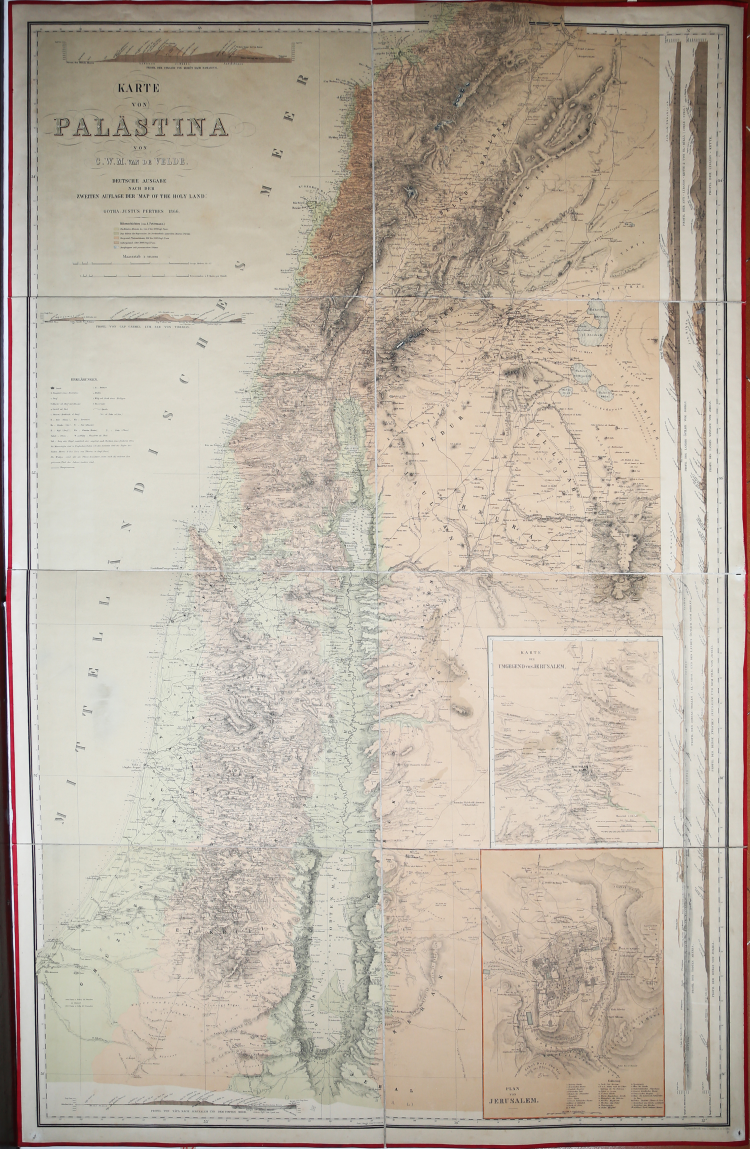
Karte von Palästina von C. W. M. van de Velde. Deutche Ausgabe nach der zweiten auflage der “Map of the Holy Land”, Gotha: Justus Perthes 1866.
German edition of the most detailed map of the Holy Land by Van de Velde, first published in 1858. Printed in Gotha by Justus Perthes in 1866.
Rare 8 sheets wall map, litograph printed with colour, laid down on original canvas and folded, perfect condition.
The van de Velde maps of Palestine and Jerusalem were an important scientific mapping of the region of Palestine and mapping of Jerusalem, published in 1858 by Dutch cartographer Charles William Meredith van de Velde. The surveys were carried out by Van de Velde during his 1851 visit to Palestine, where he carried out various surveys, drawings, paintings and around one hundred watercolours for postcards. After his trip, he held lectures on Palestine in Geneva and Lausanne. Together with the maps, Van de Velde published an album of 100 lithographs of the region. Van de Velde met Titus Tobler in Switzerland in 1855, where they agreed to make a new map of Jerusalem based on combining Tobler's own measurements with the flawed Royal Engineers map of 1840–41. Tobler published a 26-page memoir to accompany the map. The map was published in 1858 ahead of his later Map of the Holy Land. Van de Velde carried out the work alone with a 7-inch surveyor’s compass, without theodolites (which required multiple people to operate) and without making astronomical observations (which required significant time). Despite this, his map was considered the most accurate made at the time. When he returned from his trip to Palestine, he was able to obtain the 1840 Royal Engineers’ survey data, and used this in the production of this maps. Given the known flaws in the work, Van de Velde used the Royal Engineers’ raw data to construct his map, cross-comparing the data with his work as well as all known previous geographical and cartographical knowledge. Yehoshua Ben-Arieh stated that: “Ritter’s writing and van de Velde’s map together may be considered the crowning achievements of fifty years exploration and research in the geography of Palestine.” (cf. Yehoshua Ben-Arieh, The Rediscovery of the Holy Land in the 19th Century, Jerusalem, 1979, p. 147.
Faehndrich wrote that: “van de Velde’s map represented the complete body of Western geographical knowledge on Palestine, critically compiled, then verified on site and completed by his own measurements and his own (physical) experience, including the hardships needed to make a scientific map” (cf. Goren, Haim; Faehndrich, Jutta; Schelhaas, Bruno (28 February 2017). Mapping the Holy Land: The Foundation of a Scientific Cartography of Palestine, pp. 102-103).
Charles William Meredith van de Velde (born December 4, 1818 in Leeuwarden, died 20 March 1898 in Menton) was a Dutch lieutenant-at-sea second class, painter, cartographer, honorary member of the Red Cross and missionary.
Van der Velde attended the Naval Academy in Medemblik and became Lieutenant-sea second class. From 1830-1841 he worked at the topographical office in modern-day Jakarta where he eventually became director. In 1844 he had to return to Europe for health reasons, where he carried out cartographic, geographic and ethnographic work and was also employed as a draftsman, and missionary nurse. In 1844, on his return to Europe, he visited Ceylon, the Transvaal and Cape of Good Hope, where he supported the work of missions and for his services provided to French ships, was awarded a Legion of Honour. In 1851 Van de Velde visited Palestine, where he carried out various surveys, drawings, paintings and around one hundred watercolours for postcards. After his trip, he held lectures on Palestine in Geneva and Lausanne. On 13 March 1864, van de Velde was one of the first delegates from the newly formed International Committee of the Red Cross to act as an impartial intermediary in the Second Schleswig War. He assisted the wounded and captured Prussian and Austrian soldiers and helped establish the Red Cross as a relief organization in the 1863 conference resolutions. On 31 July 1867, Van de Velde was made an honorary member of the main Committee of the Red Cross, which included Willem Jan Knoop and Henri Dunant.
Charles William Meredith Van de Velde(1818-1898)
Charles William Meredith Van de Velde(1818-1898)