| Reference: | S31337 |
| Author | Franciscus HALMA |
| Year: | 1700 ca. |
| Zone: | The Roman Empire |
| Printed: | Amsterdam |
| Measures: | 855 x 380 mm |
| Reference: | S31337 |
| Author | Franciscus HALMA |
| Year: | 1700 ca. |
| Zone: | The Roman Empire |
| Printed: | Amsterdam |
| Measures: | 855 x 380 mm |
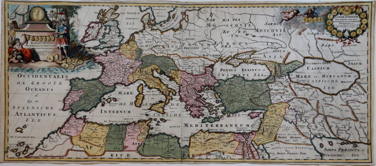
Antique map of the Mediterranean Sea, showing the Roman Empire. After N. Sanson, published by Francois Halma.
Published in "Beschryving van oud en nieuw Rome", by François Jacques Deseine.
Copperplate with fine later hand colour, very good condition.
|
Zacharakis 2104
|
Franciscus HALMA (1653 - 1722)
|
A book publisher who started business in Utrecht and later moved to Amsterdam and finally settled in Leeuwarden .Included in his prolific output of historical and theological work were issues of the atlases detailed below.
1695 Ptolemy’s Geographia
re-issues at Utrecht of Mercator’s 1578 edition : further issues1698(Franeker)
1704 (Utrecht)
(See also Appendix A.)
1704 Geographia Sacra
c. 1705-09 Description de tout l’Univers
1718 Atlas of Friesland
re-issue of work by Schotanus van Sterringa (1698)
|
|
Zacharakis 2104
|
Franciscus HALMA (1653 - 1722)
|
A book publisher who started business in Utrecht and later moved to Amsterdam and finally settled in Leeuwarden .Included in his prolific output of historical and theological work were issues of the atlases detailed below.
1695 Ptolemy’s Geographia
re-issues at Utrecht of Mercator’s 1578 edition : further issues1698(Franeker)
1704 (Utrecht)
(See also Appendix A.)
1704 Geographia Sacra
c. 1705-09 Description de tout l’Univers
1718 Atlas of Friesland
re-issue of work by Schotanus van Sterringa (1698)
|