| Reference: | S39533 |
| Author | Reiner & Joshua OTTENS |
| Year: | 1730 ca. |
| Zone: | Greece |
| Printed: | Amsterdam |
| Measures: | 600 x 510 mm |
| Reference: | S39533 |
| Author | Reiner & Joshua OTTENS |
| Year: | 1730 ca. |
| Zone: | Greece |
| Printed: | Amsterdam |
| Measures: | 600 x 510 mm |
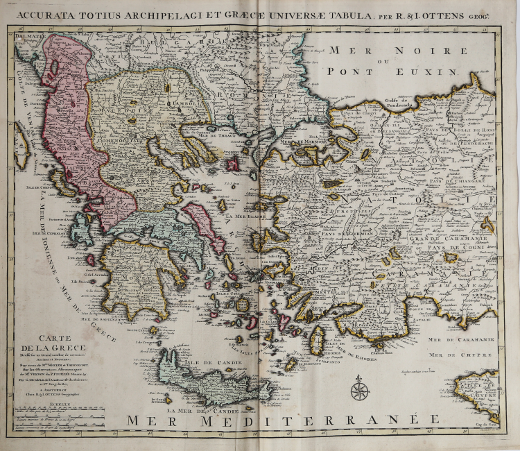
A striking, large map detailing Greece, the western part of Turkey and extending to show Albania, Macedonia and part of Cyprus.
Latin title at top "Accurata Totius Archipelagi et Graeciae Universae Tabula."
Copper engraving in good condition, old color.
|
The family business of print and map selling was founded by Joachim Ottens but the active period of map publishing was concentrated in the years between 1720 and 1750 when the brothers, Reiner and Joshua, produced enormous collections of maps, some as large as 15 volumes.
These, including copies of practically all maps available at the time, were made up to order and were magnificently coloured. Besides these specially prepared collections they also issued single-volume atlases with varying contents as well as pocket atlases.
|
|
The family business of print and map selling was founded by Joachim Ottens but the active period of map publishing was concentrated in the years between 1720 and 1750 when the brothers, Reiner and Joshua, produced enormous collections of maps, some as large as 15 volumes.
These, including copies of practically all maps available at the time, were made up to order and were magnificently coloured. Besides these specially prepared collections they also issued single-volume atlases with varying contents as well as pocket atlases.
|