
| Reference: | S29403 |
| Author | Johannes VAN KEULEN |
| Year: | 1730 ca. |
| Zone: | Ionian Sea |
| Printed: | Amsterdam |
| Measures: | 590 x 512 mm |
| Reference: | S29403 |
| Author | Johannes VAN KEULEN |
| Year: | 1730 ca. |
| Zone: | Ionian Sea |
| Printed: | Amsterdam |
| Measures: | 590 x 512 mm |
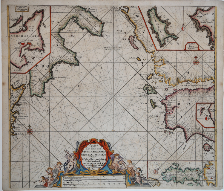
Nice example of Van Keulen's chart of the southern part of Italy and the coasts of Greece and Morea, from his De Nieuwe Groote Lichtende Zee-Fackel, part III.
Includes insets of the Harbor of Cephalonia; Zante; Porto de Prodino . Includes an ornate cartouche and other embellishments, with large insets of Corfu, the mouth of the Po River and Paxoi & Andipaxoi.
This late edition includes signficantly mre detail and additional islands to the right of the cartouche.
Copperplate with fine colour, very good condition.
Johannes VAN KEULEN (1654 - 1715)
|
As we have noted in other biographies in this chapter, the Dutch produced a remarkable number of enterprising and prolific map and chart makers but not even the Blaeu and Jansson establishments could rival the vigour of the van Keulen family whose business was founded in 1680 and continued under their name until 1823 and in other names until 1885 when it was finally wound up and the stock dispersed at auction.
Throughout the history of the family, the widows of several of the van Keulens played a major part, after their husbands' deaths, in maintaining the continuity of the business.
The firm was founded by Johannes van Keulen who was registered as a bookseller in Amsterdam in 1678. In 1680 he published the first part of his Zee Atlas which, over the years, was expanded to 5 volumes and continued in one form or another until 1734. More ambitious and with a far longer and more complicated life was his book of sea charts, the Zee-Fakkel, published in 1681-82 which was still being printed round the year 1800. A major influence in the development of the firm was the acquisition in 1693 of the stock of a rival map publisher, Hendrik Doncker.
Although the firm was founded by Johannes van Keulen, he was primarily a publisher; it was his son, Gerard, a talented engraver, mathematician, Hydrographer to the East India Company, who became the mainspring of the business which not only published charts but also books on every aspect of geography, navigation and nautical matters.
|