| Reference: | s20490 |
| Author | Joseph ROUX |
| Year: | 1764 ca. |
| Zone: | Zakynthos |
| Printed: | Leghorn |
| Measures: | 200 x 150 mm |
| Reference: | s20490 |
| Author | Joseph ROUX |
| Year: | 1764 ca. |
| Zone: | Zakynthos |
| Printed: | Leghorn |
| Measures: | 200 x 150 mm |
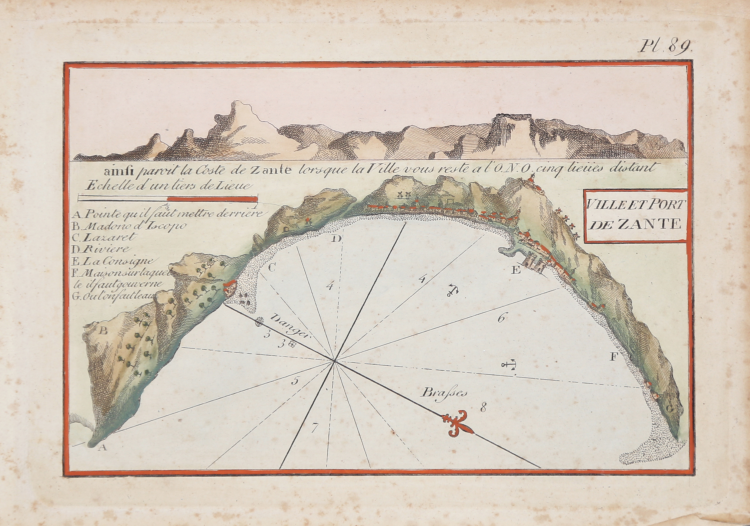
First published in the "Recueil des principaux plans des ports et rades de la Mer Mediterranee", 1764, this nice nautical chart is taken from the rare "Plans des ports ed des rades de la Mer Méditerranée.." published in Leghorn by Carlo Tesi, 1858.
Copperplate with fine colouring, in very good condition.
|
Zacharakis C. G. - A Catalogue of Printed Maps of Greece 1477 - 1800 (2009), n. 3019
|
Joseph ROUX (Attivo nella seconda metà del XVIII sec.)
|
Joseph Roux was a Marseilles hydrographer who both published and as well manufactured and sold charts, navigating instruments and related nautical equipment.
At about the mid-century, he received the right to be called "Hidrographe du Roy," and in 1764 published a series of 12 charts of the Mediterranean; he simultaneously published this smaller format atlas of 65 harbor charts. Several editions followed until well into the 19th century, both in France and in Italy, all enlarged. Some were by Roux himself, some were pirated.
Sanderson, The Sea Chart, p. 91, calls this "a popular book," but few examples survive, and all editions are rare
|
|
Zacharakis C. G. - A Catalogue of Printed Maps of Greece 1477 - 1800 (2009), n. 3019
|
Joseph ROUX (Attivo nella seconda metà del XVIII sec.)
|
Joseph Roux was a Marseilles hydrographer who both published and as well manufactured and sold charts, navigating instruments and related nautical equipment.
At about the mid-century, he received the right to be called "Hidrographe du Roy," and in 1764 published a series of 12 charts of the Mediterranean; he simultaneously published this smaller format atlas of 65 harbor charts. Several editions followed until well into the 19th century, both in France and in Italy, all enlarged. Some were by Roux himself, some were pirated.
Sanderson, The Sea Chart, p. 91, calls this "a popular book," but few examples survive, and all editions are rare
|