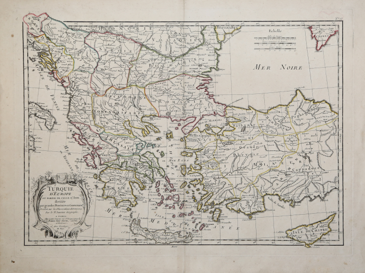
| Reference: | CO-482 |
| Author | Robert Jean JANVIER |
| Year: | 1771 ca. |
| Zone: | Greece |
| Printed: | Paris |
| Measures: | 465 x 335 mm |
| Reference: | CO-482 |
| Author | Robert Jean JANVIER |
| Year: | 1771 ca. |
| Zone: | Greece |
| Printed: | Paris |
| Measures: | 465 x 335 mm |
Tavola tratta da: Atlas moderne ou collection de cartes sur toutes les parties du globe terrestre ar plusieurs auteurs. Avec approbation & privilege du Roy. A Paris, Chez Lattre Graveur Ordinaire du Roy, de Mgr. Le Duc d'Orleans et de la Ville Rue St. Jacques No. 20. et Delalain Libraire, rue de la Comedie Francoise.
Jean Lattré fu incisore ordinario del Re e di Monseigneur le Dauphin (1767) prima, del duca di Orleans e della città di Parigi poi (1771). Si specializzò molto presto nell’intaglio di mappe e piante di città, ma fu anche calligrafo, come sua moglie, nata Vérard. Ha lavorato in associazione con il libraio e editore Nicolas-Augustin Delalain (dal 1771); parte del suo fondo fu acquisito nel 1801 da Charles-Antoine-Florimond Dien.
Janvier è stato un cartografo francese della seconda metà del settecento di cui si hanno poche informazioni ad iniziare dal nome in quanto, se generalmente si trova la sua segnatura come Sr. Janvier (il Signor Janvier) come in questa carta geografica d'Italia oppure Le Sieur Janvier, qualche altra volta ha firmato come Robert o Jean Denis Janvier. Anche la data di nascita non è certa, si sa che iniziò l'attività a Parigi verso il 1746. Ciò che è certo è che le sue mappe sono accurate e costruite sulle migliori e più recenti fonti, a dimostrazione di una attenzione non sempre riscontrabile tra i cartografi e gli editori del XVIII secolo, e che furono a loro volta ritenute tanto ben fatte da essere riprese da altri autori anche fuori Francia.
Acquaforte, coloritura coeva dei contorni, in ottimo stato di conservazione.
Robert Jean JANVIER (Attivo 1746 - 1776)
|
A French cartographer who worked in Paris from about 1746. There is some confusion about his Christian name but his maps usually bore the inscriptions”Le Sieur Janvier”. In addition to works published under his own name by Jean Lattré in Bordeaux and C. F. Delamarche in Paris, he collaborated with other cartographers and publishers, producing a considerable numbers of maps, many of which were used in general atlases by William Fadan, P.Santini and others.
1751 Map in Atlas de Geographie ancienne et moderne by Jean de Beaurain
1751 (with S.G. Longchamps) Map of France
1754 Map of America
1759 Les Isles Britanniques
1779,1791 re-issued
c.1760 Maps of the world,the Continents and France and Germany
1762 re-issued on a reduced scalein Atlas Moderne
1763 re-issued in Atlas abrégé et portraif by P. M. Gournè
1762 Atlas Moderne ou collection de Cartes
1771 re-issued
1772 Map of America
1776-84 Maps in Atlas Universel by P.Santini
|