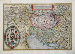
Nova exactissimaque descriptio Danubii Gerard DE JODE Code: S27948 Measures: 500 x 340 mm Year: 1570 ca. Printed: Antwerpen Price €2,500.00 Quick view View Details
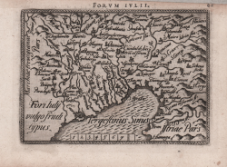
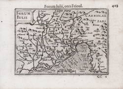
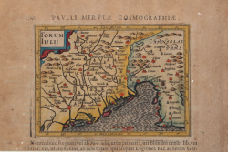
Fori Iulii Accurata Descriptio Abraham ORTELIUS Code: A53737 Measures: 480 x 360 mm Year: 1573 ca. Printed: Antwerpen Price €900.00 Quick view View Details
Foi Iuly vulgo friuli typus Abraham ORTELIUS - Philip GALLE Code: S22033 Measures: 105 x 70 mm Year: 1577 ca. Printed: Antwerpen Price €180.00 Quick view View Details
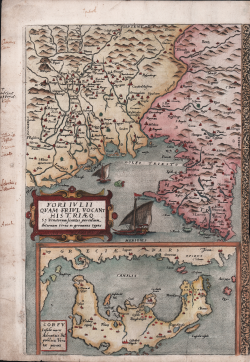
ori Iulii quam Friuli vocant Histriaeq(ue)… typus / Corfu Insula... Gerard DE JODE Code: S38308 Measures: 250 x 365 mm Year: 1578 ca. Printed: Antwerpen Price €1,100.00 Quick view View Details
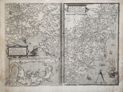
Fori Iuli/ Corfu/ Tusciae Insignis Italiae provincia Vera ac... Gerard DE JODE Code: CO-737 Measures: 510 x 370 mm Year: 1578 ca. Printed: Antwerpen Price €1,200.00 Quick view View Details
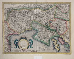
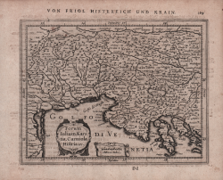
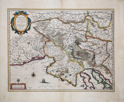
Forum Iulium, Karstia, Carniola, Histria et Windorum Marchia Gerard MERCATOR (Kremer) Code: s29402 Measures: 470 x 355 mm Year: 1589 ca. Printed: Amsterdam Price €650.00 Quick view View Details
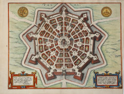
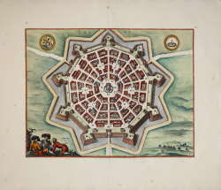
Nova Palmae civitas in patria Foroiuliensis ab maris Adriatici... Georg BRAUN & Franz HOGENBERG Code: S49238.183 Measures: 470 x 360 mm Year: 1596 ca. Printed: Antwerpen & Cologne Price €800.00 Quick view View Details
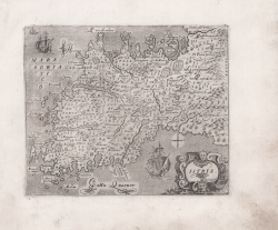
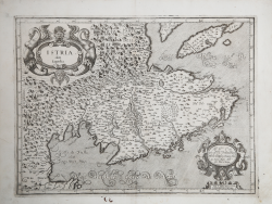
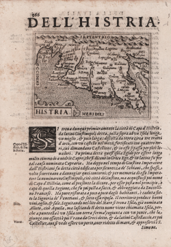
Istria Giuseppe ROSACCIO Code: S26269 Measures: 173 x 140 mm Year: 1597 ca. Printed: Venice Price €750.00 Quick view View Details
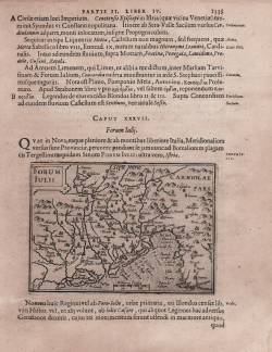
Forum Iulii Jodocus HONDIUS Code: S27031 Measures: 120 x 85 mm Year: 1598 ca. Printed: Amsterdam Price €160.00 Quick view View Details
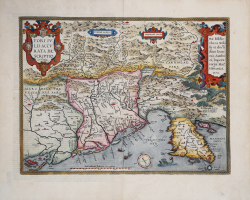
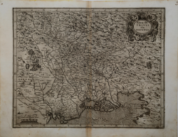
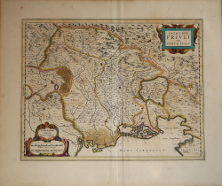
Patria del Friuli olim Forum Iulii Giovanni Antonio MAGINI Code: S32406 Measures: 455 x 355 mm Year: 1598 ca. Printed: Bologna Price €4,500.00 Quick view View Details
Istria olim Iapidia Giovanni Antonio MAGINI Code: S40980 Measures: 480 x 355 mm Year: 1604 ca. Printed: Bologna Price €450.00 Quick view View Details
Forum Iulii Barent LANGENES Code: S50592 Measures: 125 x 85 mm Year: 1609 Printed: Frankfurt Price €125.00 Quick view View Details
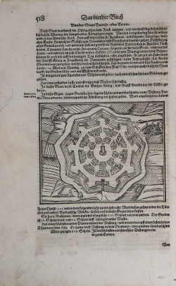
(Palmanova) Sebastian Münster Code: S29387 Measures: 155 x 125 mm Year: 1614 ca. Printed: Basle Price €125.00 Quick view View Details
Forum Iulii Jodocus HONDIUS Jr. Code: S25053 Measures: 135 x 100 mm Year: 1616 ca. Printed: Amsterdam Price €160.00 Quick view View Details
Histria Giacomo SARZINA Code: s24906 Measures: 110 x 80 mm Year: 1623 Printed: Venice Price €150.00 Quick view View Details
Forum Iulium, Karstia, Carniola, Histria Johannes JANSSONIUS Code: S48161 Measures: 190 x 148 mm Year: 1628 ca. Printed: Amsterdam Price €125.00 Quick view View Details
Karstia, Carniola, Histria et Windorum Marchia. Ger. Mercatore Auctore Willem Janszoon BLAEU Code: S45387 Measures: 505 x 390 mm Year: 1635 ca. Printed: Amsterdam Price €500.00 Quick view View Details
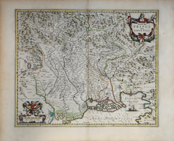
Patria del Friuli olim Forum Iulii Hendrick HONDIUS Code: MS3686 Measures: 485 x 380 mm Year: 1636 ca. Printed: Amsterdam Price €550.00 Quick view View Details
Patria del Friuli olim Forum Iulii Willem Janszoon BLAEU Code: MS5209 Measures: 520 x 415 mm Year: 1640 ca. Printed: Amsterdam Price €550.00 Quick view View Details
Palma Johannes JANSSONIUS Code: S48509 Measures: 470 x 360 mm Year: 1657 ca. Printed: Amsterdam Price €800.00 Quick view View Details