| Reference: | S41912 |
| Author | Melchior TAVERNIER |
| Year: | 1646 |
| Zone: | Piedmont & Savoy |
| Measures: | 595 x 730 mm |
| Reference: | S41912 |
| Author | Melchior TAVERNIER |
| Year: | 1646 |
| Zone: | Piedmont & Savoy |
| Measures: | 595 x 730 mm |
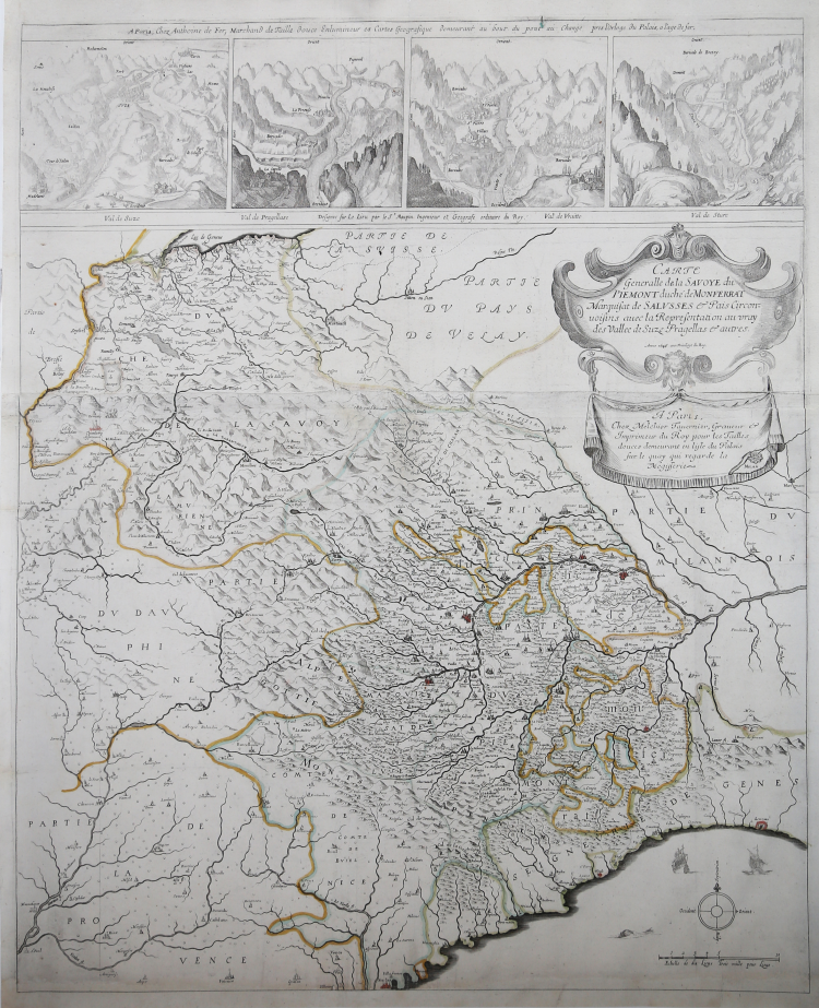
Rare 2 sheet Tavernier Map of Savoy Region, with a remarkable set of vignettes of Valleys in the Grand Alps.
The map extends from Savoy to the Mediterranean (between Nice and Genoa), covering the entire Grandes Alps region between Geneva in the north, Grenoble in the west and Casale in the east.
The upper edge is decorated with four views of the alpine valleys designed by Simon Maupin, architect from Lyon and the king's engineer-geographer: the Susa Valley, the Pragellato valley, the Varaita valley and the Stura valley. The southern part of Piedmont is filled with place names, while indications are rare in the upper part and especially in the massifs of Mont Blanc and Grand Paradis.
This map was used by Hondius and Janssonius for their famous Sabaudia Ducatus of 1630.
The map is exceedingly rare on the market.
Example of the second state with the imprint by Anthoine De Fer and the date 1646.
A fine example, printed on contemporary laid paper, perfect repaired areas in the lower margin, otherwise perfect condition.
Literature
Aliprandi, Le Grandi Alpi nella Cartografia, vol. I, pp. 176-177, n. 99; Pastoreau, Atlas Francais, Tavernier II A 1625, carta 61,
Melchior TAVERNIER (1564 ca. - 1644)
|
He was a member of a large family involved in the publishing trade in Paris in the early years of the seventeenth century .He is probably best known for his publication of a map of the Post Roads of France which was copied many times until the end of the century.He also issued an atlas under the same title as J. Le Clerc’s Theatre Geographique,using many of Le Clerc’s maps,but incorporating others from the maps noted below ,he pubblished works for other cartographers,including N.Sanson ,N.Tassin,and P.Bertius.He is not to be confused with his nephew of the same name (1594-1665),who also engraved maps for Nicolas Sanson.
1632 Carte Geographique des Postes qui traversent la France
1658 re-issued by N.Sanson
1634 Theatre Geographique du Royaume de France
1640-42 Description de la Carte Generale de tout le Monde
|