| Reference: | s22223 |
| Author | Johannes Baptiste VRIENTS |
| Year: | 1606 ca. |
| Zone: | France |
| Printed: | Antwerpen |
| Measures: | 480 x 400 mm |
| Reference: | s22223 |
| Author | Johannes Baptiste VRIENTS |
| Year: | 1606 ca. |
| Zone: | France |
| Printed: | Antwerpen |
| Measures: | 480 x 400 mm |
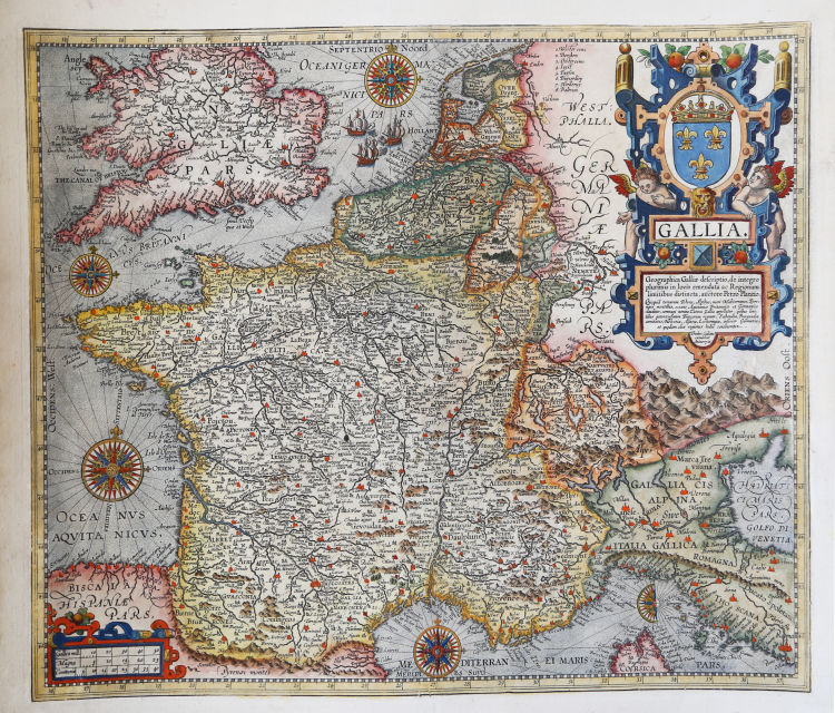
Title in the cartouche: GALLIA | Geographica Galliæ descriptio, de integro | plurimis in locis emendata ac Regionum | limitibus distincta; auctore Petro Plantio. | "Quicquid terrarum Rheno, Alpibus, mari Mediterraneo, Pyre: | næis montibus, oceano Aquitanico Brittanico et Germanico, | clauditur; communi nomine Latinis Gallia appellatur: quibus limi: | tibus potentissimum Francorum regnum, Sabaudiæ, Burgundiæ | comitatus, Helvetia, Alsatia, Lotharingia, inferior Germania, | et quædam aliæ regionis hodie continentur. | Ioannes Bap: | tista Vrints | excudit" [A geographical depiction of France, entirely improved in many places and distinguished by the borders of its regions; by Petrus Plancius, the lands of which are defined by the Rhine, the Alps, the Pyrenee mountains, and the Mediterranean, British and German oceans, called with its general Latin name Gallia; The present borders of this mighty kingdom of the French are Sabaudia, Burgundy, Helvetia, Alsatia, Lotharingia, Lower Germany and some other regions. Made by Ioannes Baptista Vrients].
One of the rare decorative Vrients maps which were added to the Ortelius Atlas from 1606 on.
The map is a faithful and misleading copy of the map of Petrus Plancius (1552-1622), engraved by the van Deutecum brothers and published by Vrients himself in 1592.
Example in the second state, imprinted Theodor. Gallæus | excudebat | Antverpiæ, which appears in the 1612 edition.
Map taken from the Theatrum Orbis Terrarum, which is considered the first true modern "Atlas". The work was published in 7 languages and 36 editions, for which - in 1570 - Ortelius obtained the privilege, a kind of copyright that prevented other cartographers from publishing his works. The Theatrum represented the most advanced work of cartographic description. Ortelius collected in it the geographical and cartographic knowledge of his time, proposing in 147 spectacular engraved plates the most faithful image of the world then known and, in some extraordinary "historical maps", regions and routes taken from literature, mythology, tradition. Ortelius was also the first to cite sources, mentioning the names of cartographers in the "catalogus auctorum". From 1598 to 1612 the posthumous editions of the Theatrum were made by his collaborator Johannes Baptiste Vrients.
Etching and engraving, impressed on contemporary paper and trimmed at marginal line, with coeval margins added, slight lack of engraved portion below cartouche, otherwise in good condition. Rare.
Bibliografia
Cfr. L. Bagrow, A. Ortelli Catalogus Cartographorum; cfr. C. Koeman, Atlantes Neerlandici; Peter H. Meurer, Fontes Cartographici Orteliani 150; M. Van den Broecke, Ortelius Atlas Maps, n. 36 II/II; Van der Krogt, Koeman’s Atantes Neerlandici: 4000:31C.
Johannes Baptiste VRIENTS (1552 - 1612)
|
Vrients was the map engraver and publisher in Antwerp who, after the death of Ortelius in 1598, acquired the publication rights of the Theatrum. Between 1601 and 1612 he issued a number of editions which included some of his own maps and he was responsible for printing the maps for the English edition in 1606. He also published a number of important individual maps and a small atlas of the Netherlands.
|