| Reference: | S222 |
| Author | Tommaso PORCACCHI |
| Year: | 1713 ca. |
| Zone: | Corsica |
| Printed: | Padua |
| Measures: | 147 x 110 mm |
| Reference: | S222 |
| Author | Tommaso PORCACCHI |
| Year: | 1713 ca. |
| Zone: | Corsica |
| Printed: | Padua |
| Measures: | 147 x 110 mm |
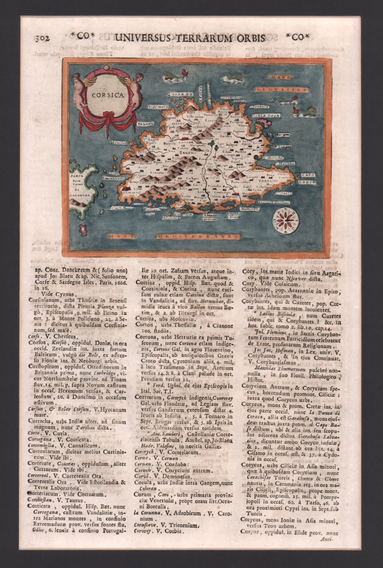
Map taken form “L’isole Piu Famose Del Mondo Descritte Da Thomaso Porcacchi Da Castiglione Aretino E Intagliate Da Girolamo Porro Padovan” by Tommaso Porcacchi (ca. 1532-1576), humanist and scholar from Castiglion Fiorentino.
The geographical interests cultivated since Pomponio Mela in 1557 gave life to the treatise published in 1572 by the company between the bookseller Simone Galignani and the Paduan engraver Girolamo Porro, who used the typography of Giorgio Angelieri (with the privilege of 10 years July 1572).
The volume, with a dedication by Galignani to Don Giovanni d'Austria, presents the magnificent calcographic plates by Porro (a second edition, conspicuously augmented with text and tables, came out in 1576, then again, posthumously, in 1590, 1604, 1605, 1620 and 1686). In the dedicatory letter Porro tells of having been the promoter of the operation and of having entrusted Porcacchi with writing a book on the islands, reserving the illustration. The model is that of the "isolari", on which however Porcacchi inserts the spirit of ancient chorographies, adding a physical, historical and cultural description for each island. The concept is very broad (including peninsulas, large islands such as England or entire continents: North America), but in the "Prohemio" Porcacchi provides a glossary of geographical terms that testifies to the effort to correctly use the terminology of the discipline (see Franco Pignatti, Porcacchi Tommaso, in "Dizionario Biografico degli Italiani" - Volume 85, 2016).
In the text there are maps of islands engraved on half a page, including the planisphere - reduction of the wall map of Camocio of 1567 and the "carta marina”.
This example is taken from the work Universus terrarum orbis scriptorum calamo delineatus ... qui de Europae, Asiae, Africae, & Americae regnis, provinciis, populis, civitatibus.... published in Padua in 1713, at Matteo Cadorin, by Raffaello Savonarola, under the pseudonym of Lasor a Varea (or Varela).
The work was a kind of encyclopedia containing news about the various localities of the world arranged in alphabetical order, enriched with maps and views of the whole world belonging to famous cartographic collections of the past-Bertelli, Valegio, Camocio, Bonifacio, Nelli, Magini, and others-of which the publisher Cadorin probably possessed the original plates.
Copper engraving, fine later hand colour, in excellent condition.
|
F. Cervoni, "Image de la Corse", 9
|
Tommaso PORCACCHI (1530 - 1585
|
Following Bordone and Camocio, Porcacchi issued in Venice another “Island Book” incorporating later discoveries and including maps of the world and the continents. It continued to appear in new editions for over a century.
1572 L’isole più famose del mondo
|
|
F. Cervoni, "Image de la Corse", 9
|
Tommaso PORCACCHI (1530 - 1585
|
Following Bordone and Camocio, Porcacchi issued in Venice another “Island Book” incorporating later discoveries and including maps of the world and the continents. It continued to appear in new editions for over a century.
1572 L’isole più famose del mondo
|