| Reference: | S41704 |
| Author | Louis-Joseph MONDHARE |
| Year: | 1788 |
| Zone: | Europe |
| Printed: | Paris |
| Measures: | 1500 x 1200 mm |
| Reference: | S41704 |
| Author | Louis-Joseph MONDHARE |
| Year: | 1788 |
| Zone: | Europe |
| Printed: | Paris |
| Measures: | 1500 x 1200 mm |
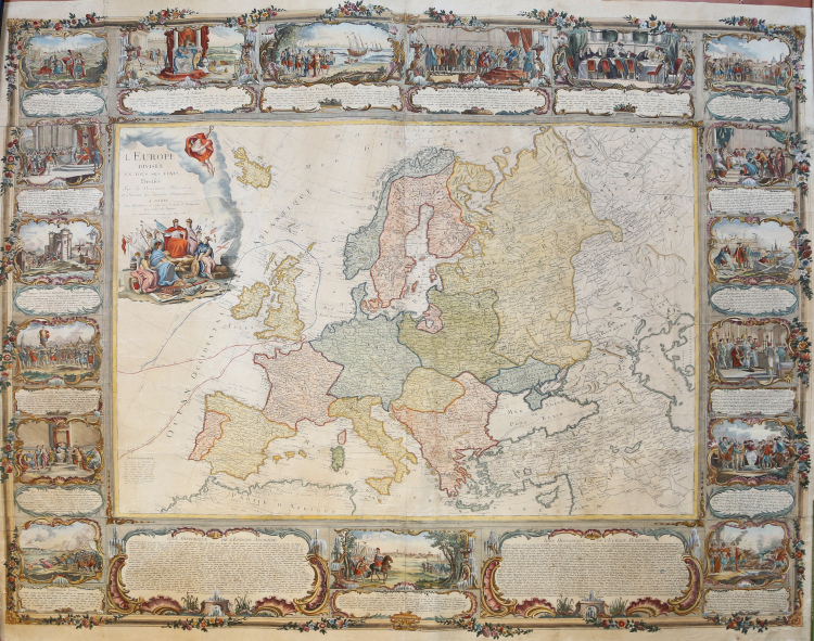
Large hand-coloured engraved wall-map of late 18th-century map of Europe: shows the divisions of the continent and its constituant countries in 1788. Hand engraved and measuring 1.2m x 1.5m in size, this map features 17 vignette around the central feature.
The map cover all of Europe from Spain to eastern Russia and the Caspian Sea. It’s surrounded by 17 vignettes illustrating the history of Europe (Fondation de Rome, Fondation de Venise, Fondation de la monarchie polonoise, etc.). On the map the route of Captain Cook in 1768 and 1769, and his retour 1775. All vignettes are explained by text beneath. The map was printed just before the french revolution and shows Europe dominated by kings.
Mondhare's wall map of Europe was one of a small group of decorative wall maps published in France in the second half of the 18th Century, which were intended to be both objects of beauty and cartographic importance. The fashion of decorating private aristocratic libraries, salons and places of business with wall maps became fashionable in the 17th Century and flourished with the masterpieces published by the great mapmakers of Amsterdam, Paris and Rome in the 17th and 18th Centuries. At the height of this design trend, artists such as Johannes Vermeer frequently depicted such wall maps in important paintings of the period, depicting the home lives of Europe's elite and learned classes.
Mondhare began publishing prints with the address of the Hôtel de Saumur, rue Saint-Jacques, where he produced prints and maps, including optical views. His business ceased around 1792 and he was succeeded by his son-in-law Pierre Jean, with whom he had been associated for several years. This map was published with both the imprint “Mondhare Et Jean, 1788”.
Copper engraving, with fine hand color. In fairly good condition, slightly toned, restored with some loss and areas in facsimile.
Louis-Joseph MONDHARE (1734 - 21 agosto 1799)
|
Louis-Joseph Mondhare, born in 1734 and died on August 21, 1791, was a Parisian engraver, publisher and print dealer, originally from Normandy.
Cert was in Paris around 1759, when he began publishing prints with the address of the Hôtel de Saumur, rue Saint-Jacques, where he produced prints and maps, including optical views.
Married to Marie-Anne Chaperon, he had a daughter, Marie-Jeanne-Barbe Mondhare, who married Pierre Jean, a native of La Manche, in 1784. His business ceased around 1792 and he was succeeded by his son-in-law Pierre Jean, with whom he had been associated for several years.
|