| Reference: | S21314 |
| Author | Benedetto MARZOLLA |
| Year: | 1857 |
| Zone: | Europe |
| Printed: | Naples |
| Measures: | 820 x 600 mm |
| Reference: | S21314 |
| Author | Benedetto MARZOLLA |
| Year: | 1857 |
| Zone: | Europe |
| Printed: | Naples |
| Measures: | 820 x 600 mm |
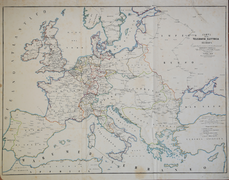
One of the first maps ever published depicting the electric telegraphy, whose first use, thanks to Samuel Morse, started in the 1840s. In a few years, this communication system spread all over Europe, ousting the ancient optic telegraphers, with a limited range.
This new system started operating in Italy in 1849, in the Lombardo-Veneto area, on the Innsbruck-Verona line, connecting Vienna, Verona, Milan and Venice. In less than ten years all the Italian States had introduced the electric telegraphy and the whole territory was using this system, especially in the North. The first line to open in the Southern part was the one connecting Caserta to Capua, in 1851 immediately extending, as the map of Marzolla shows, southbound, to Calabria and Sicily. There are evidences of projects realized in 1858 to extend the lines from Capua towards L’Aquila and Pescara, and from Ariano towards Brindisi. The Papal State was working on the line which had to connect Rome to Siena, to reach afterwards Florence and the North.
The map shows also some submarine cables, placed for the first time in 1850, between Dover and Calais. The first submarine cable of Italy, in the Straits of Messina, was placed in 1851, followed by the one between Sarzana, Corsica and Sardinia (1854). This work is a very interesting document, for it provides, at a glance, a whole of data and information that nowadays could be hardly recovered, being kept in different sources. The map was realized in 1857, at the Stabilimento Geografico of Benedetto Marzolla (1801-1858), cartographer and geographer from Brindisi, who studied at the Officio Topografico in Naples.
Marzolla had the chance to access a huge amount of geographic data and information for, starting from 1852, he worked as a compiler for the Commissione di Statistica of the Reign of Naples, created by the Minister of the Interior.
Map taken from the Atlante geografico. Corredato di notizie relative alla geografia fisica politica, ed in generale alla statistica delle varie regioni del Globo. Compilato ed eseguito in litografia per cura e sotto la direzione di Benedetto Marzolla published in Naples in 1856.
Marzolla, author of important atlases on the provinces of the Kingdom of Naples, is also the author of several maps on the Ecclesiastical Circumscriptions in the Kingdom of the Two Sicilies, published posthumously in the same year of his death (1858) in Naples in the Stabilimento Geografico directed by Luigi Manzella.
Benedetto Marzolla was draftsman topographer and lithographer, geographer and cartographer. Character of great importance in the Neapolitan and Italian cartography of the nineteenth century, Marzolla obtained during his life public recognition and certificates for the production of high quality cartography. His notoriety slowly faded after his death; it should be noted, however, that only the lack of a strong political involvement in the sense of the Risorgimento and of a literary value in his work did not make him as famous as his contemporaries Francesco Costantino Marmocchi (1805-1858) and Attilio Zuccagni-Orlandini (1783-1872), with whom he can certainly compare himself. Marzolla's cultural, didactic and editorial projects were, and remain, extraordinarily modern; he invented a new way of understanding and drawing maps, providing an absolutely original vision of the communication of geographical data through the combination of text and image. With this operation, he was able to merge in a single work, history, geography, economics, statistics and cartography, achieving a graphic balance of rare effectiveness.
Beautiful specimen with contemporary coloring of the contours, in excellent condition.
Bibliografia
V. Valerio, Benedetto Marzolla Brindisino, Geografo e Cartografo dell’800 Europeo (2008).
Benedetto MARZOLLA (Brindisi, 1801 - Napoli, 1858)
|
Designer surveyor and lithographer, and cartographer, geographer and member of the Commission of Statistics, Ministry of Interior. Character of great importance in the Neapolitan and Italian maps of the nineteenth century, Marzolla won awards and certificates in public life for the cartographic production of high quality. His reputation has slowly dissolved after death, it should be observed that only the lack of a strong political involvement in the Risorgimento and the sense of literary value in his work not made him famous contemporaries such as Francesco Costantino Marmocchi (1805-1858) and Attilio Zuccagni Orlandini (1783-1872), with which it can certainly deal with. Cultural projects and educational publishing Marzolla were and remain extraordinary modernity, he invented, it is appropriate to say, a new way of understanding and to draw the map, providing a totally original data communication through a combination of geographic text and image. With this, he managed to merge into a single work, history, geography, economics, statistics and maps, reaching an equilibrium graph with outstanding performance.
(Cfr. by V. Valerio, Benedetto Marzolla Brindisi,Geografo e Cartografo dell' 800 Europeo, Brindisi 2008)
|