
| Reference: | S367800 |
| Author | Jacques Nicolas BELLIN |
| Year: | 1757 ca. |
| Zone: | Thailand, Indochina |
| Printed: | Paris |
| Measures: | 280 x 285 mm |
| Reference: | S367800 |
| Author | Jacques Nicolas BELLIN |
| Year: | 1757 ca. |
| Zone: | Thailand, Indochina |
| Printed: | Paris |
| Measures: | 280 x 285 mm |
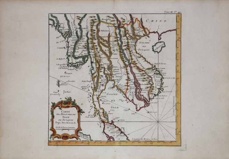
Finely engraved map of Southeast Asia, from Jacques Nicolas Bellin's Le Petit Atlas Maritime Recueti de Cartes et Plans des Quatre Parlies du Monde en Cinq Volumes, first published in Paris in 1764.
The Petit Atlas Maritime is probably the best compilation of plans of maritime towns and harbors of its time. According to Tooley, Bellin issued an earlier version of this atlas in 1763 titled Petit Atlas Francois. The Duc de Choiseul provided financial support for the publication of the atlas. J. Arrivet is listed as engraver on the chart index pages and may also have engraved the charts themselves.
Jacques Nicolas Bellin (1703-1772) is among the most important mapmakers of the 18th Century. In 1721, at age 18, he was appointed hydrographer (chief cartographer) to the French Navy. In August 1741, he became the first Ingénieur de la Marine of the Depot des cartes et plans de la Marine (the French Hydrographical Office) and was named Official Hydrographer of the French King.
During his term as Official Hydrographer, the Depot was the single most active center for the production of sea charts and maps, including a large folio format sea-chart of France, the Neptune Francois. He also produced a number of sea-atlases of the world, e.g., the Atlas Maritime and the Hydrographie Francaise. These gained fame, distinction and respect all over Europe and were republished throughout the 18th and even in the succeeding century.
Bellin also came out with smaller format maps such as the 1764 Petit Atlas Maritime, containing 580 finely detailed charts. He also contributed many of the maps for Bellin and contributed a number of maps to the 15 volume Histoire Generale des Voyages of Antoine François Prévost or simply known l'Abbe Prevost.
Bellin set a very high standard of workmanship and accuracy, thus gaining for France a leading role in European cartography and geography. Many of his maps were copied by other mapmakers of Europe..
Copperplate, with fine later hand colour, in good conditions.
Jacques Nicolas BELLIN (1703 - 1772)
|
Jacques-Nicolas Bellin (1703 - 1772) was one of the most important cartographers of the 18th century.
With a career spanning some 50 years, Bellin is best understood as transitional mapmaker spanning the gap
between 18th and early 19th century cartographic styles. His long career as Hydrographer and Ingénieur
Hydrographe at the French Dépôt des cartes et plans de la Marine resulted in hundreds of high quality
nautical charts of practically everywhere in the world. Bellin's work focuses on function and accuracy
tending in the process to be less decorative than the earlier 17th and 18th century cartographic work. In
addition to numerous maps and charts published during his lifetime, many of Bellin's maps were updated
(or not) and published posthumously. He was succeeded as Ingénieur Hydrographe by his student, also a prolific and influential cartographer, Rigobert Bonne.
|