| Reference: | S45268 |
| Author | Vincenzo CORONELLI |
| Year: | 1688 ca. |
| Zone: | China |
| Printed: | Venice |
| Measures: | 620 x 460 mm |
| Reference: | S45268 |
| Author | Vincenzo CORONELLI |
| Year: | 1688 ca. |
| Zone: | China |
| Printed: | Venice |
| Measures: | 620 x 460 mm |
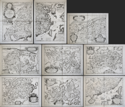
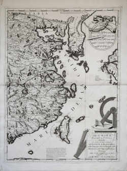
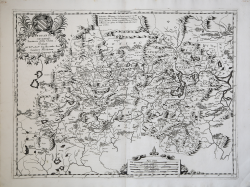
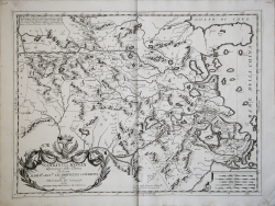
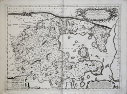
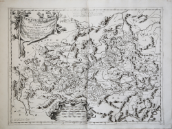
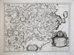
Complete series of the eight maps dedicated to China by Vincenzo Coronelli, all double-page except the general map, which is printed on two sheets [plate size, each, about 460 by 620 mm].
Include:
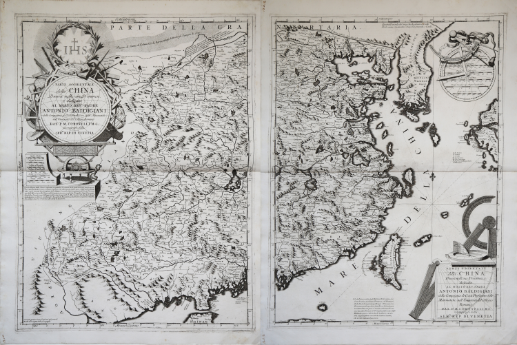
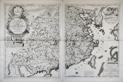
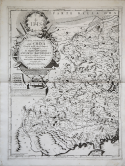
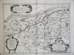
- Parte Occidentale ❘ della China | Diuisa nelle sue Provincie, e dedicata Al Molto Rev. Padre | Antonio Baldigiani | della Compagnia di Gesù. Professore delle Matematiche nelll'Vniuersità del Collegio Romano | Dal P.M. Coronelli M.C. Cosmografo della Ser.Ma Rep. di Venetia.
- Parte Orientale | della China, Diuisa nelle sue Provincie, e dedicata Al Molto Rev. Padre | Antonio Baldigiani | della Compagnia di Gesù Professore delle | Matematiche nelll'Uniuersità del Collegio | Romano | Dal P.M. Coronelli M.C. Cosmografo della | Ser.ma Rep. di Venetia
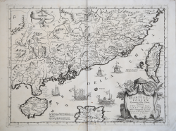
- Hounang, e Sucuhen Provincie della China, Dedicate All’ Ill.mo et Ecc.mo Sig. Alessandro Zen Senatore Meritissimo, Dal P. Coronelli, Cosmografo Publico
- Nanking, et Honan Provincie della China Dedicate All’ Ill.mo, et Ecc.mo Sig. Bertuccio Contarini Dal P. M. Coronelli M. C. Cosmografo della Serenissima Republica di Venetia.
- Xantung, e Peking Provincie della China, divise nelle sue Regioni e dedicate a Mons.re Ill.mo e Rev.mo Severoli, Referendario dell’una e l’altra SIgnatura dal P. M. Coronelli M. C. Cosmografo della Ser.ma Republica di Venetia.
- Xansi, e Xensi, Provincie della China Dedicate All’Illustrissimo Signor Commendatore Fra Paolo Passionei Cavaliero Gerosolimitano, e Castellano Governatore del Forte Urbano nello Stato Ecclesiastico dal P. Cosmografo Coronelli.
- Quantung, e Fokien Provincie della China, Dedicate Al Molto Reverendo Padre Carlo Trigona della Compagnia di Gesù, Teologo di Monsignor Illustriss[imo] Arcivescovo di Palermo, etc.
- Unanqueichev, e Quangsi Provincie della China Dedicate All Ill.mo Ecc.mo Sig.r il Sig.r Cavalier Girolamo Zen Savio Grande Dal P. M. Coronelli M. C. Cosmografo Della Ser.ma Republica di Venetia.
- Chekiang, e Kiangsi Provincie della China, Dedicate All’Illustrissimo Signore Marco Gradenico, dell’Ecc. S. Procuratore Girolamo Dal P. Coronelli, Cosmografo della Serenissima Republica.
An important series of maps that constitute one of the best examples of Coronelli's cartographic work; in addition to being a state-of-the-art representation of China, they also provide a visual compendium of the tools used by a 17th-century surveyor and cartographer. The precisely engraved instruments that decorate the maps are a tribute to the technical skills of the Jesuit missionaries, whose surveys formed the basis of the maps.
Coronelli dedicated the two-sheet general map to Antonio Baldigiani (1647-1711), a Jesuit and successor to Athanasius Kircher as professor of mathematics at the Jesuit Roman College. From 1691, Baldigiani was a consultant to the Sacred Congregation of the Index, a Church body charged with censoring publications deemed dangerous to the Catholic faith. In this role, he was a rather important link between the rapidly developing scientific world and the Church.
The Jesuits played an active role in China, seeking opportunities to showcase their technical skills and scientific knowledge to Chinese intellectuals. They believed that if the Chinese intelligentsia could persuade the superiority of Western learning, they could influence even the powerful to convert to Christianity. One of the most dramatic means of making this demonstration was the creation of maps, some of which were printed in China and in the Chinese language; some were of enormous size to increase their impact. Perhaps Coronelli had in mind that this set of maps could be used in the same way by his ecclesiastical colleagues.
The maps were published first as loose sheets, then in Corso geografico universale (Venice: Vincenzo Coronelli, 1692). According to Marica Milanesi (cfr. Vincenzo Coronelli Cosmographer (1650-1718), 2016, pp. 211-215 and 396), it was released as a loose sheet in July 1688.
For a description of the map of China, we refer to Marco Caboara's recent publication, Regnum Chinae, The Printed Western Maps of China to 1735:
“Coronelli here followed French maps of China quite closely, especially the one by Father Couplet in 1687; even the name of the Yellow River remains in French, laune F. (Yellow River), instead of changing to the Italian "Fiume Giallo". On the western sheet, under the title cartouche, and a summary of the information that was on Couplet's map: Questo Regno della China è ripartito in quindeci Prouinciè delle quali dourano publicarsi le sue Carte partiolari. Sono seminate in questo, 155. Metropoli, ch'ano. 1312. Città subordinate, oltre 2357. Castelli ben fortificati. Il P. Filippo Couplet della Compagnia di Gesù, Procurator delle Missioni nella China, riferi sparse in essa 10128789. Famiglie, Capi d'huomeni 58916783. Duecento sono li Tempij eretti in più tempi à D. O M., e Gesù C. R. dal zelo di quella Religione indefessà, uentiquatro Luoghi di Residenza, marcati col publico Blasone, tre Collegi; diuersi Oratorij, e Hospitij di Missioni.
The cartouches show a dedication to an important figure of the Jesuit order, Father Antonio Baldigiani (1647-1771). For this reason, instead of the usual heraldic coat of arms, we see the "IHS" monogram of the Society of Jesus, and numerous references to Jesuit missionaries on the map.
In the north-eastern corner Coronelli devoted a descriptive text to Korea: Questa Penisola di Corea, che da alcuno si crede Isola, uiene chiamata Coreij, Tiocencouk, e Caoli (This peninsula of Korea, which is believed by some to be an island, is called Coreij, Tiocencouk, and Caoli). To the left of Korea, Coronelli mentioned the Great Wall: Muro antico che diuide la China dalla gran Tartaria (The ancient Wall, which divides China from Great Tartary). North of Shanxi, Coronelli wrote a longer text for the Great Wall: Linea del Muro diuisorio della China dalla Tartaria lungo 400 Leghe, edificato gia duemila Anni e più, con scarpa di pietra uiua, fra le ringhiere interrotte de' Monti, continuato con Porte magnifiche, e Propugnacoli rileuati, e decorato con un Pomerio, ò Pomuro, da una parte e dall'altra.
For Taiwan, following Couplet's example, Coronelli used a French instead of an Italian name: BELL'ISLE, ou ILHA FORMOSA, da' Portoghesi LAQUEIO. Only in a long caption to the south of the island did Coronelli propose the Italian name: L'Isola Formosa, detta dagli Habitanti Ta Lieukieu, cioe, Gran Lieukieu, da Chinesi, Formosa, e da' Francesi Belle Isle, il di cui principal Luogo è Theouan, con Fortezza quadrangolare, detta Nuova Zelanda, posta nell'Isoletta, che pure si nomina Theouan. Vi sono anco due altre Fortez- ze da' Portoghesi fabricate dagli Hollandesi prese coll'Isola, che la ten- nero sin al 1661, nel quale furno cacciati da Coxina Corsaro, che ne tiene tuttavia il possesso”.
Cosmografo e cartografo, Vincenzo o Vincenzo Maria Coronelli (1640-1718) fondò la prima società geografica, l'Accademia degli Argonauti. Nel 1678 costruì una coppia di globi per il Duca di Parma che attirò l'attenzione dell'ambasciatore francese César d'Estrée, il quale invitò Coronelli a Parigi. Lì Coronelli costruì la coppia di globi giganteschi di 15 piedi che presentò a Luigi XIV nel 1683 e che gli avrebbero procurato fama in tutta Europa. Coronelli visse un periodo di straordinaria fecondità editoriale a partire dal 1689, quando ebbe la cattedra di geografia presso l'Università alle Procuratie, con la pubblicazione, nel 1690, del primo volume dell'Atlante Veneto. In effetti sotto il nome di Atlante Veneto va tutta la raccolta di tredici opere composte nell'arco del decennio successivo, dall'Isolario allo Specchio del mare. In realtà solo alcune di tali opere possono definirsi atlante, e sono di valore molto disuguale, dato che si passa da opere originali e fondamentali come quelle citate o il Corso Geografico ad opere di compilazione o semplici raccolte di vedute. Il Corso Geografico uscì in diverse edizioni con numeri diversi di carte - sessantotto tavole nel 1689-92; di centosettantatré tavole nel 1692; duecentosessanta tavole, nel 1694-97 - che venivano vendute anche separatamente, al ritmo di sei carte al mese per due anni. Le carte furono incise tra il 1688 e il 1692 nell'attrezzatissima officina cartografica del convento dei Frari, dove lavoravano anche incisori stranieri.
A Minorite friar, cosmographer and cartographer, Vincenzo or Vincenzo Maria Coronelli (1640-1718) founded the first geographical society, the Accademia degli Argonauti. In 1678 he built a pair of globes for the Duke of Parma that attracted the attention of the French ambassador, César d’Estrée who subsequently invited Coronelli to Paris. There Coronelli built the pair of gigantic, 15-foot globes which he presented to Louis XIV in 1683 and which would bring him fame throughout Europe. Upon his return to Venice, Coronelli was contracted by Jean-Baptiste Nolin (1657-1725) to publish a replica of these globes, scaled down to a diameter of 3 ½ -foot, and financed through subscription by members of the Argonauti.
Coronelli lived a period of extraordinary editorial fecundity starting from 1689, when he had the chair of geography at the University at the Procuratie, with the publication, in 1690, of the first volume of the Atlante Veneto. Under the name of Atlante Veneto goes the entire collection of thirteen works composed over the next decade, from the Isolario to the Specchio del mare. In reality, only some of these works can be defined as atlas, and are of very unequal value, since we go from original and fundamental works such as those mentioned or the Corso Geografico to works of compilation or simple collections of views. The Corso Geografico came out in several editions with different numbers of maps - sixty-eight maps in 1689-92; one hundred and seventy-three maps in 1692; two hundred and sixty maps in 1694-97 - which were also sold separately, at the rate of six a month for two years. The maps were alle engraved between 1688 and 1692 in the well-equipped cartographic workshop of the Frari convent, where foreign engravers also worked.
Set of maps in perfect condition.
Bibliografia
Marco Caboara, Regnum Chinae, The Printed Western Maps of China to 1735, pp. 409-413, n. 96; E. Armao, Vincenzo Coronelli: Cenni sull’uomo e la sua Vita. Catalogo Ragionato delle sue opere, lettere, fonti bibliografiche, indici; Marica Milanesi,Vincenzo Coronelli Cosmographer (1650-1718).
Vincenzo CORONELLI (Venezia 1650 - 1718)
|
Cosmographer, geographer, biographer, encyclopedist, globe maker, inventor, expert of engeneering and hydraulics. Extraordinarily versatile mind and an extremely tireless man, he produced more than 140 pieces in different genres. At the age of 15, he entered the Franciscan Order, which he then guided as Gran Generale from 1699. He became famous as geographer and mathematician, awakening the interest in these subjects in Italy at the end of the XVII century. He travelled a lot, seeking for all that was new, and keeping a correspondance with the most important intellectuals of his time. In 1681 Louis XIV wanted him to go to France, to entrust him with the task of making two terraqueous globes (Marly Globes), with a diameter of 4 metres. Once he came back to Italy, in 1685, he became Cosmographer of the Venetian Republic, where he taught geography and founded the first geographic accademy, called The Argonauts Accademy. In his whole life he produced more that 500 maps; some of them can be found in his most famous works, such as the Venetian Atlas (1690), the Island Book of the Venetian Atlas (1696-97), the Book of Globes (1693). As far as his scientific method, he didn’t elaborate new cartographic systems, but followed the theories that were considered most popular and effective at his time, based on the Copernican system. The main characteristic of his charts is the high quantity of toponymic and historical information. In his most famous and dense work, the Venetian Atlas, we can find about 1100 plates, 200 of which are extremely technical and this is the reason why it is considered the first Italian atlas to describe and illustrate the whole world with charts and maps. It was published in 13 volumes, starting from 1690, and it took nearly ten years to finish it. It is divided in different parts, the most important are the Atlas itself, then the Island Book, the Corso Geografico and the Teatro delle città.
|