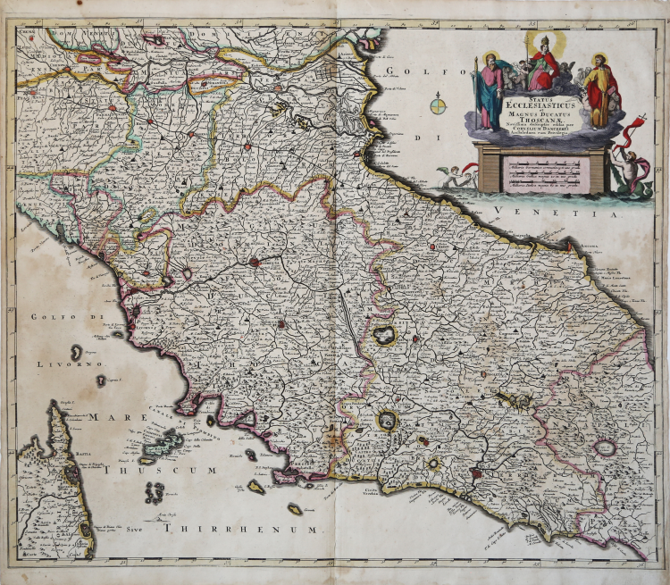
| Reference: | CO-084 |
| Author | Cornelis II DANKERTS |
| Year: | 1696 ca. |
| Zone: | Central Italy |
| Printed: | Amsterdam |
| Measures: | 605 x 505 mm |
| Reference: | CO-084 |
| Author | Cornelis II DANKERTS |
| Year: | 1696 ca. |
| Zone: | Central Italy |
| Printed: | Amsterdam |
| Measures: | 605 x 505 mm |
Rara carta geografica dello Stato della Chiesa con la Toscana pubblicata da Cornelis II Dankerts verso il 1696 circa. Koeman ne segnala un esemplare nella raccolta di carte geografiche, tutte firmate dalla famiglia Dankerts, conservata al Maritime Museum di Rotterdam (cfr. Koeman II, Dan 3, n. 20). L’atlante reca, nella pagina di indice alla fine, l’imprint Amstelodami, Apud Cornelius Dankerts, in Platea vitulina vulgo de Nieuwendijk, in signo de Atlas. L’indirizzo identifica Conerlis II Dankerts (1664-1717), figlio di Justus I Dankerts e nipote di Cornelis I Danckerts (1603-1656), fondatore della calcografia.
I Danckerts erano una famiglia di incisori e geografi olandesi che producevano materiale geografico, tra cui una serie di atlanti originali. Inizialmente, Justus I Danckerts (1635-1701) era un editore di libri e stampe con sede ad Amsterdam. Il suo prozio, Cornelis Danckerts de Rij (1561-1634), era un topografo che produsse un Kaert-boeck con varie vedute di Amsterdam. Suo fratello, Dancker Danckerts (1634-1666), fu un abile incisore che produsse diverse mappe. Molto probabilmente Justus I fu influenzato dal lavoro di entrambi quando seguì il padre, Cornelis I Danckerts (1603-1656), nell'attività editoriale. All'inizio degli anni '80 del XVI secolo, Justus decise di intraprendere un nuovo progetto, un atlante con tutte le mappe realizzate in casa. Questo progetto era realizzabile perché due dei suoi figli con la moglie, Elisabeth Vorsterman, Teodoro I (1663 ca. - 1720 ca.) e Cornelis II (1664-1717), erano da poco diventati maggiorenni e avevano una formazione in incisione e acquaforte. La decisione di Justus fu probabilmente influenzata dall'ambiente circostante; Amsterdam era il centro dell'editoria cartografica del XVII secolo e negli anni '80 del XVI secolo diversi editori locali cercarono di entrare nel mercato degli atlanti, allora dominato dagli atlanti Blaeu e Hondius-Janssonius. Insieme, i fratelli crearono le loro prime mappe a metà degli anni '80 del XVI secolo. Nel 1684, la famiglia ottenne un privilegio di 15 anni per la protezione delle proprie mappe e pubblicò sia mappe in formato in-folio, la base di un atlante, sia mappe murali per la vendita. I loro primi atlanti contenevano circa 20 mappe originali e 4-5 mappe di altri cartografi come Visscher e De Wit. Il primo atlante di cui si abbia notizia che contenga solo mappe di Danckerts è un volume di 26 fogli pubblicato nel 1690. Come esempio, i Danckerts si rivolsero ad atlanti simili di De Wit, ma nel 1690 avevano chiaramente la conoscenza e la capacità di produrre un proprio lavoro originale. Sebbene non sia stata così longeva come altre imprese familiari, per i decenni a cavallo del Seicento la famiglia Danckerts produsse mappe murali e atlanti molto apprezzati e ampiamente distribuiti. L'ingresso nel commercio degli atlanti avvenne in un momento di crescente popolarità e l'espansione del numero di fogli inclusi nei loro atlanti indica sia la loro popolarità sia l'abilità dei fratelli incisori.
Acquaforte, bella coloritura coeva, leggere ossidazioni nel mare, per il resto in ottimo stato di conservazione. Rara.
Bibliografia
Koeman II, Dan 3, n. 20.
Cornelis II DANKERTS (Amsterdam 1664-1717)
|
The Danckerts were a family of Dutch engravers and geographers who produced geographical material, including a series of original atlases. Initially, Justus I Danckerts (1635-1701) was a book and print publisher based in Amsterdam. His great uncle, Cornelis Danckerts de Rij (1561-1634), was a topographer who produced a Kaert-boeck with various views of Amsterdam. His brother, Dancker Danckerts (1634-1666), was a skilled engraver who produced several maps. Most likely Justus I was influenced by the work of both when he followed his father, Cornelis I Danckerts (1603-1656), into the publishing business. In the early 1680s, Justus decided to undertake a new project, an atlas with all the maps made at home. This project was feasible because two of his sons with his wife, Elisabeth Vorsterman, Theodore I (c. 1663-c. 1720) and Cornelis II (1664-1717), had recently come of age and had training in engraving and etching. Justus' decision was probably influenced by his surroundings; Amsterdam was the center of cartographic publishing in the 17th century, and in the 1680s several local publishers sought to enter the atlas market, then dominated by Blaeu and Hondius-Janssonius atlases. Together, the brothers created their first maps in the mid-1680s. In 1684, the family was granted a 15-year privilege to protect their maps and published both in-folio maps, the basis of an atlas, and wall maps for sale. Their early atlases contained about 20 original maps and 4-5 maps by other cartographers such as Visscher and De Wit. The earliest atlas known to contain only Danckerts' maps is a 26-sheet volume published in 1690. As an example, the Danckerts turned to similar atlases by De Wit, but by 1690 they clearly had the knowledge and ability to produce their own original work. Although it was not as long-lived as other family businesses, for the decades at the turn of the seventeenth century the Danckerts family produced highly regarded and widely distributed wall maps and atlases. Their entry into the atlas trade came at a time of growing popularity, and the expansion in the number of sheets included in their atlases indicates both their popularity and the skill of the engraving brothers.
|