
| Reference: | CO-250 |
| Author | Eredi Johannes Baptiste HOMANN |
| Year: | 1748 |
| Zone: | Central Italy |
| Printed: | Nurnberg |
| Measures: | 570 x 500 mm |
| Reference: | CO-250 |
| Author | Eredi Johannes Baptiste HOMANN |
| Year: | 1748 |
| Zone: | Central Italy |
| Printed: | Nurnberg |
| Measures: | 570 x 500 mm |
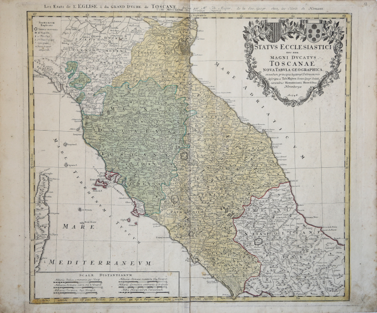
Carta geografica dello Stato della Chiesa con la Toscana, tratta dall'opera Atlas Compendiarus quinquaginta tabularum geographicarum Homannianis alias in Atlante majori..., stampato a Norimberga, presso gli Homannianos heredes, nel 1752. Esistono ristampe sino al 1790 сirca.
“La graduazione ai margini, di 5' in 5', va da 41° 13' a 45° lat. e da 26° 58' a 33° 03' long. Orientazione su tre lati (quello in basso è occupato da precisazioni circa la longitudine riferita al meridiano dell'Isola di Ferro). Ben sei le scale, in miglia italiane comuni, miglia romane antiche e recenti, miglia toscane, parigine e tedesche. Nel cartiglio, con cornice ornata da risvolti artistici e tralci floreali, sono inseriti il titolo della carta e i nomi del cartografo T. Mayer e degli stampatori. Di ragguardevoli dimensioni, e raffigurante lo Stato della Chiesa e il Granducato di Toscana, la tavola è ispirata alle note carte del Magini del 1620. Tuttavia, da quei prototipi, così come dalle carte del Sanson e dello Jaillot ancora di impostazione seicentesca, questa si discosta in modo abbastanza evidente: è infatti diverso il profilo geografico del tratto di penisola rappresentato, che appare più snello attenuato nelle frastagliature costiere. La qualità della carta è impreziosita dall'uso del colore, verde per il Granducato di Toscana, giallo per lo Stato Pontificio. Notevole il grado di dettaglio riservato ai vari elementi geografici (orografia, idrografia, numero di località). I centri abitati maggiori, fra cui Spoleto, sono raffigurati con una stilizzata pianta topografica di colore rosso. La nomenclatura è in latino. L'Umbria torna a essere indicata con il sempre meno frequente nome di Ducatus Spoletanus. Semplice, ma elegante, è il cartiglio a motivi fitomorfi raffigurante gli stemmi mediceo e del casato dei Lambertini di Benedetto XIV”
Johann Baptist Homann è stato un geografo e cartografo tedesco; nel 1702 fondò la sua casa editrice. Homann acquisì fama come uno dei principali cartografi tedeschi, e nel 1715 fu nominato geografo imperiale dall'imperatore Carlo VI. Nello stesso anno fu anche nominato membro dell'Accademia Prussiana delle Scienze a Berlino. Nel 1716 Homann pubblicò il suo capolavoro Grosser Atlas ueber die ganze Welt. Numerose mappe furono redatte in collaborazione con l'incisore Christoph Weigel. Homann morì a Norimberga nel 1724. Gli successe suo figlio Johann Christoph (1703-1730). L'azienda continuò dopo la sua morte come azienda degli eredi Homann, gestita da Johann Michael Franz e Johann Georg Ebersberger. Dopo successivi cambiamenti nella gestione, l'azienda si sciolse nel 1852.
Acquaforte, coloritura editoriale, in ottimo stato di conservazione.
Eredi Johannes Baptiste HOMANN (1730 - 1813)
|
Johann Baptist Homann (20 March 1664 – 1 July 1724) was a German geographer and cartographer
born in Oberkammlach near Kammlach in the Electorate of Bavaria. Although educated at a Jesuit school, and preparing for an ecclesiastical career, he eventually converted to Protestantism and from 1687 worked as a civil law notary in Nuremberg. He soon turned to engraving and cartography; in 1702 he founded his own publishing house. Homann acquired renown as a leading German cartographer, and in 1715 was appointed Imperial Geographer by Emperor Charles VI. Giving such privileges to individuals was an added right that the Holy Roman Emperor enjoyed. In the same year he was also named a member of the Prussian Academy of Sciences in Berlin. Of particular significance to cartography were the imperial printing privileges (Latin: privilegia impressoria). These protected for a time the authors in all scientific fields such as printers, copper engravers, map makers and publishers. They were also very important as a recommendation for potential customers. In 1716 Homann published his masterpiece Grosser Atlas ueber die ganze Welt (Grand Atlas of all the World). Numerous maps were drawn up in cooperation with the engraver Christoph Weigel the Elder, who also published Siebmachers Wappenbuch. Homann died in Nuremberg in 1724. He was succeeded by his son Johann Christoph (1703-1730). The company carried on upon his death as Homann heirs company, managed by Johann Michael Franz and Johann Georg Ebersberger. After subsequent changes in management the company folded in 1852. The company was known as "Homann Erben", "Homanniani Heredes", or "Heritiers de Homann" abroad.
1702-07 Atlas novus terrarum
1712 Enlarged edition with re-issues to c.1753
c.1714 Neuer Atlas
re-issues to c. 1730
1719 Atlas Methodicus
1730 America Septentrionali Britannorum
1737 Grosser atlas
re-issues to c. 1770
|