| Reference: | CO-087 |
| Author | Nicolas DE FER |
| Year: | 1719 |
| Zone: | Central Italy |
| Printed: | Paris |
| Measures: | 580 x 520 mm |
| Reference: | CO-087 |
| Author | Nicolas DE FER |
| Year: | 1719 |
| Zone: | Central Italy |
| Printed: | Paris |
| Measures: | 580 x 520 mm |
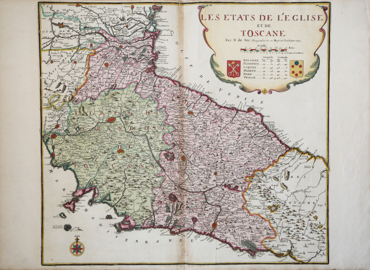
Rara carta geografica dello Stato della Chiesa con la Toscana tratta dall'opera Atlas ou Recueil de cartes géographiques, dressées les nouvelles observations de messieurs de l'Academie Royale des Sciences, par N. de Fer... Paris, chez l'Auteur, 1709-28, del quale esiste una ristampa, con numero maggiore di carte, pubblicata nel 1746-53.
“Il quadro non è graduato. L'orientamento è chiarito dalla rosa dei venti collocata in basso a sinistra. Le scale, in miglia e in leghe, sono inserite assieme al titolo e all'Autore della tavola, in un cartiglio, con bella ma semplice cornice dai risvolti floreali che in basso incorniciano gli stemmi pontificio e mediceo (tra questi sono riportate le coordinate geografiche di sei fra le maggiori città dell'Italia Centro-Settentrionale). Carta da apprezzare per la meticolosa registrazione degli insediamenti umani, dei confini di stato ed interni a lettere più grandi compaiono le città capoluogo - e per la cura nel disegno dell'idrografia; con monticelli, illuminati da sinistra, sono raffigurati i rilievi, la loro distribuzione ha però scarsa efficacia nel procurare la percezione delle reali caratteristiche oro-morfologiche. Un sicuro interesse offre la viabilità, disegnata con doppia linea tratteggiata, raramente indicata nelle carte contemporanee o precedenti. Non mancano storpiature toponomastiche (Piè di Lago per Piediluco, Scorpio per Scoppio ovvero Scopoli, Strepeto per Sterpeto, Cereto per Cerreto ecc.)” (cfr. "Le antiche terre del Ducato di Spoleto", p. 152).
Nicolas de Fer (1646-1720) è stato uno dei più grandi cartografi, incisori ed editori del XVII secolo. Il padre, Antoine de Fer, era un modesto mercante di stampe che lavorava sull’Ile del la Cité a Parigi; collaborò con Nicolas I Berey, poi con Melchior Tavernier e, quindi, con Jacques Lagnet. Nel 1652 Antoine adotta l’insegna commerciale della “Sphére royale”, già appartenuta a Tavernier; nel 1657 stampa Cartes de géographie, una piccola raccolta tascabile di Pierre Duval. Nel 1667 si firmava “merchand de cartes Gèographique”; proseguì l’attività fino al 1686, quando lasciò la tipografia nelle mani del figlio Nicolas, che aveva fatto da apprendista all’incisore parigino Louis Spirinx e aveva già realizzato la sua prima mappa del Canal du Midi, all’età di soli 23 anni. Nel 1689 realizzò una mappa della Franche-Comté per onorare il Grand Dauphine - Luigi di Francia (1661-1711), primogenito ed erede del re Luigi XIV di Francia, impegnato al comando di una campagna di conquistare di nuovi territori sul Reno. In seguito, venne nominato geografo ufficiale del Delfinato e la sua produzione fu strettamente legata agli interessi della corona francese: ad esempio, Forces De L’Europe Ou Introduction A La Fortification, pubblicato nel 1695, che mostrava le nuove fortificazioni progettate dall’innovativo ingegnere francese Sébastien de Vauban. Fu il geografo ufficiale anche di Filippo V e Luigi XIV (entrambi i rami francese e spagnolo della Casa di Borbone) e infine, nel 1720, del Papa. De Fer pubblicò l’Atlas curieux où le Monde représenté dans les cartes générales et particulièrs du Ciel et de la Terre tra il 1700 e il 1705, aggiungendo ogni volta delle nuove tavole geografiche. La sua opera più maestosa rimane l’Atlas Royal, dans l’Isle du Palais sur le Quay de l'Orloge a la Sphere royale (1693). Alla sua morte, l’attività fu ereditata da suo genero Guillaume Danet, che si unì poi con Jacques-François Benard.
Acquaforte, bella coloritura coeva, tracce di colla alla piega centrale, per il resto in ottimo stato di conservazione.
|
F. Ronca e A. Sorbini (a cura di) "Le antiche terre del Ducato di Spoleto", p. 152, 62.
|
Nicolas DE FER (1646-1720 circa)
|
One of the most prolific and influential French geographers and cartographers of the late 17th and early 18th Century. Nicolas was the youngest son of Parisian print and mapseller, Antoine de Fer [d.1673]. He produced numerous atlases: Atlas Curieux [1700-5] and its subsequent suites; Atlas ou Receuil des Cartes [1709]; Atlas Royale [1699]; Les Beautés de la France [1708]; Atlases detailing wars and countries relating to the Spanish succession [1701]; Italy [1702] & Germany [1705] and Franco-Belgian frontiers [1708-10]; Les Forces de L'Europe [1690-95]; Introduction à la Géographie [1708]; the Petit Nouveau Atlas [1697]. Aswell as his Atlas output de Fer is also well known for his large Wall maps, some 26 in total, aswell as large-scale town plans of European cities, and a signifcant output of thematic printed card games. His sign and emblem was the Sphère Royale, originally that of Melchior Tavernier, to which he was greatly attached and which appears on a large number of his works. He died on 25th October 1720 and his estate was divided between his three daughters, all three of whose husbands were closely involved in the Parisian engraving and publishing business : Guillaume Danet, Remi Richer, Jaques-Francois Besnard or Bénard. A number of de Fer's maps and atlases continued to be published by his heirs for another twenty or thirty years.
|
|
F. Ronca e A. Sorbini (a cura di) "Le antiche terre del Ducato di Spoleto", p. 152, 62.
|
Nicolas DE FER (1646-1720 circa)
|
One of the most prolific and influential French geographers and cartographers of the late 17th and early 18th Century. Nicolas was the youngest son of Parisian print and mapseller, Antoine de Fer [d.1673]. He produced numerous atlases: Atlas Curieux [1700-5] and its subsequent suites; Atlas ou Receuil des Cartes [1709]; Atlas Royale [1699]; Les Beautés de la France [1708]; Atlases detailing wars and countries relating to the Spanish succession [1701]; Italy [1702] & Germany [1705] and Franco-Belgian frontiers [1708-10]; Les Forces de L'Europe [1690-95]; Introduction à la Géographie [1708]; the Petit Nouveau Atlas [1697]. Aswell as his Atlas output de Fer is also well known for his large Wall maps, some 26 in total, aswell as large-scale town plans of European cities, and a signifcant output of thematic printed card games. His sign and emblem was the Sphère Royale, originally that of Melchior Tavernier, to which he was greatly attached and which appears on a large number of his works. He died on 25th October 1720 and his estate was divided between his three daughters, all three of whose husbands were closely involved in the Parisian engraving and publishing business : Guillaume Danet, Remi Richer, Jaques-Francois Besnard or Bénard. A number of de Fer's maps and atlases continued to be published by his heirs for another twenty or thirty years.
|