| Reference: | CO-107 |
| Author | Nicolas SANSON |
| Year: | 1648 |
| Zone: | Central Italy |
| Printed: | Paris |
| Measures: | 565 x 430 mm |
| Reference: | CO-107 |
| Author | Nicolas SANSON |
| Year: | 1648 |
| Zone: | Central Italy |
| Printed: | Paris |
| Measures: | 565 x 430 mm |
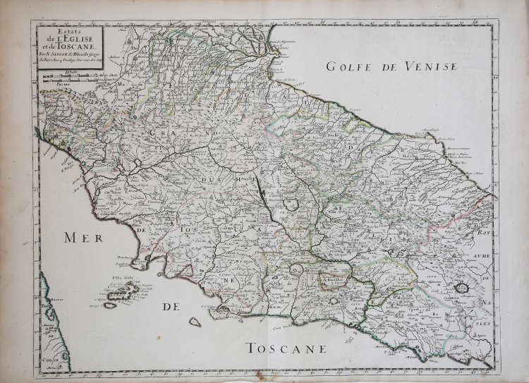
Carta tratta dall'opera Cartes générales de toutes les parties du monde, ou les empires, monarchies, républiques, estats, peuples, & c. de l'Asie, de l'Afrique, de l'Europe, & de l'Amerique, tant anciens que nouveaux, sont exactement remarqués & distingués suivant leur estenduë. Par les Sieurs Sanson d'Abbeville, géographes ordinaires du roy. Pubblicato a Parigi, da Pierre Mariette, 1654. Ristampe 1658, 1664-66, 1667, 1670.
“La graduazione ai margini, di 2' 30" in 2' 30", va da 41° 20' a 44° 30' e da 32° 18' a 38° 12' ca. long. ca. lat. Manca di orientazione. Due le scale, in miglia italiane e leghe francesi. In una semplice targa rettangolare sono il titolo della carta, il suo Autore e la data di pubblicazione. Per questa tavola, edizione ridotta di quella titolata "Estat du Grand Duc de Toscane et Estats de l'Église...", assai rara e presumibilmente anteriore al 1648, l'Almagià (DCSP, p. 44) pone in risalto l'evidente derivazione dalle carte maginiane - oltre la maggiore estensione dell'area raffigurata - e dalle carte regionali a disposizione dalle quali l'Autore avrebbe desunto elementi di conoscenza «con maggiore larghezza e abilità di altri», escludendo così i risultati personali di ricognizioni locali, dichiarate fin dalla prima edizione in formato maggiore. La presente è carta comunque assai più nota per essere stata inserita nella raccolta delle Cartes générales comprendente 11 carte d'Italia, oltre ad una generale; a confermarne il successo stanno le numerose riproduzioni, tra cui quella inserita nel Mercurio Geografico di M. A. Baudrand. È carta di pregio notevole, secondo lo stesso Almagià, almeno per l'idrografia e i centri abitati, indicati con simboli diversi a seconda della loro grandezza (i minori sono localizzati con un cerchietto); è da convenire altresì che piuttosto sommaria è la raffigurazione dell'orografia. Utili risultano i confini delle partizioni interne (Duché de Spolète, Terre Sabine ecc.) e l'indicazione dei numerosi ponti (sui fiumi Tevere, Nera, Arno, Chiana ecc.). Non mancano comunque storpiature toponimiche varie (Maltarella per Matterello, Castel Rinadi per Castel Rinaldi, Sigello per Sigillo ecc.)” (cfr. "Le antiche terre del Ducato di Spoleto", p. 76).
Acquaforte, coloritura coeva dei contorni, in ottimo stato di conservazione.
|
F. Ronca e A. Sorbini (a cura di) "Le antiche terre del Ducato di Spoleto", p. 76, n. 24.
|
Nicolas SANSON (Abbeville 1600 - Parigi 1667)
|
Nicolas Sanson (December 20, 1600 - July 7, 1667) and his descendants were the most influential French cartographers of the 17th century and laid the groundwork for the Golden Age of French Cartography. Sanson was born in Picardy, but his family was of Scottish Descent. He studied with the Jesuit Fathers at Amiens. Sanson started his career as a historian where, it is said, he turned to cartography as a way to illustrate his historical studies. In the course of his research some of his fine maps came to the attention of King Louis XIII who, admiring the quality of his work, appointed Sanson Geographe Ordinaire du Roi. Sanson's duties in this coveted position included advising the king on matters of geography and compiling the royal cartographic archive. In 1644 he partnered with Pierre Mariette, an established print dealer and engraver, whose business savvy and ready capital enabled Sanson to publish an enormous quantity of maps. Sanson's corpus of some three hundred maps initiated the golden age of French mapmaking and he is considered the 'Father of French Cartography.' His work is distinguished as being the first of the 'Positivist Cartographers,' a primarily French school of cartography that valued scientific observation over historical cartographic conventions. The practice result of the is less embellishment of geographical imagery, as was common in the Dutch Golden Age maps of the 16th century, in favor of conventionalized cartographic representational modes. Sanson is most admired for his construction of the magnificent atlas Cartes Generales de Toutes les Parties du Monde. Sanson's maps of North America, Amerique Septentrionale (1650), Le Nouveau Mexique et La Floride (1656), and La Canada ou Nouvelle France (1656) are exceptionally notable for their important contributions to the cartographic perceptions of the New World. Both maps utilize the discoveries of important French missionaries and are among the first published maps to show the Great Lakes in recognizable form. Sanson was also an active proponent of the insular California theory, wherein it was speculated that California was an island rather than a peninsula. After his death, Sanson's maps were frequently republished, without updates, by his sons, Guillaume (1633 - 1703) and Adrien Sanson (1639 - 1718). Even so, Sanson's true cartographic legacy as a 'positivist geographer' was carried on by others, including Alexis-Hubert Jaillot, Guillaume De L'Isle, Gilles Robert de Vaugondy, and Pierre Duval.
|
|
F. Ronca e A. Sorbini (a cura di) "Le antiche terre del Ducato di Spoleto", p. 76, n. 24.
|
Nicolas SANSON (Abbeville 1600 - Parigi 1667)
|
Nicolas Sanson (December 20, 1600 - July 7, 1667) and his descendants were the most influential French cartographers of the 17th century and laid the groundwork for the Golden Age of French Cartography. Sanson was born in Picardy, but his family was of Scottish Descent. He studied with the Jesuit Fathers at Amiens. Sanson started his career as a historian where, it is said, he turned to cartography as a way to illustrate his historical studies. In the course of his research some of his fine maps came to the attention of King Louis XIII who, admiring the quality of his work, appointed Sanson Geographe Ordinaire du Roi. Sanson's duties in this coveted position included advising the king on matters of geography and compiling the royal cartographic archive. In 1644 he partnered with Pierre Mariette, an established print dealer and engraver, whose business savvy and ready capital enabled Sanson to publish an enormous quantity of maps. Sanson's corpus of some three hundred maps initiated the golden age of French mapmaking and he is considered the 'Father of French Cartography.' His work is distinguished as being the first of the 'Positivist Cartographers,' a primarily French school of cartography that valued scientific observation over historical cartographic conventions. The practice result of the is less embellishment of geographical imagery, as was common in the Dutch Golden Age maps of the 16th century, in favor of conventionalized cartographic representational modes. Sanson is most admired for his construction of the magnificent atlas Cartes Generales de Toutes les Parties du Monde. Sanson's maps of North America, Amerique Septentrionale (1650), Le Nouveau Mexique et La Floride (1656), and La Canada ou Nouvelle France (1656) are exceptionally notable for their important contributions to the cartographic perceptions of the New World. Both maps utilize the discoveries of important French missionaries and are among the first published maps to show the Great Lakes in recognizable form. Sanson was also an active proponent of the insular California theory, wherein it was speculated that California was an island rather than a peninsula. After his death, Sanson's maps were frequently republished, without updates, by his sons, Guillaume (1633 - 1703) and Adrien Sanson (1639 - 1718). Even so, Sanson's true cartographic legacy as a 'positivist geographer' was carried on by others, including Alexis-Hubert Jaillot, Guillaume De L'Isle, Gilles Robert de Vaugondy, and Pierre Duval.
|