| Reference: | CO-545 |
| Author | Istituito Geografico WEIMAR |
| Year: | 1856 ca. |
| Zone: | Central Italy |
| Printed: | Weimar |
| Measures: | 280 x 225 mm |
| Reference: | CO-545 |
| Author | Istituito Geografico WEIMAR |
| Year: | 1856 ca. |
| Zone: | Central Italy |
| Printed: | Weimar |
| Measures: | 280 x 225 mm |
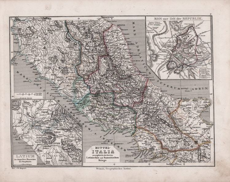
Carta dell’Italia centrale con la Toscana; in basso a sinistra un riquadro con il particolare del Lazio; in alto a destra un particolare della città di Roma.
Tratta da Allgemeiner Hand-Atlas der Erde und des Himmels nach den besten astronomischen Bestimmungen, neuesten Entdeckungen und kritischen Untersuchungen entworfen. Geographisches Institut in Weimar senza data, ma circa 1856.
Le carte sono firmate da C.F. Weiland, H. Kiepert; alcune datate (tra il 1846 e il 1856).
Nel 1803 Bertuch e August Ferdinand Götze (ca 1775- dopo 1816), autori di numerose mappe, presero in mano l'edizione dell'Handatlas ma, a partire dal 1804, compare come dato editoriale il nome del Geographische Institut fondato sempre a Weimar come divisione autonoma della casa editrice madre, con il compito di incidere e pubblicare carte geografiche e atlanti scolastici e storici.
Incisione in rame, coloritura editoriale, in perfetto stato di conservazione.
|
Founded by friecrich Justin Bertuch in 1804 in Weimar, to engrave, print and publish both domestic and foreign geographical and cartographical publications including shool atlases, historical atlases, regional, world and special atlases. The Institut took over the publication of many of the maps first created and published by the Landes-Industrie Comptoir. Many important mapmakers worked for the company including: Gussefeld, August and Adolf Stieler, Heirich Hiepert ecc.
|
|
Founded by friecrich Justin Bertuch in 1804 in Weimar, to engrave, print and publish both domestic and foreign geographical and cartographical publications including shool atlases, historical atlases, regional, world and special atlases. The Institut took over the publication of many of the maps first created and published by the Landes-Industrie Comptoir. Many important mapmakers worked for the company including: Gussefeld, August and Adolf Stieler, Heirich Hiepert ecc.
|