| Reference: | s38095.2 |
| Author | Dépôt des cartes et plans de la Marine |
| Year: | 1841 |
| Zone: | The Maldives Islands |
| Printed: | Paris |
| Measures: | 640 x 960 mm |
| Reference: | s38095.2 |
| Author | Dépôt des cartes et plans de la Marine |
| Year: | 1841 |
| Zone: | The Maldives Islands |
| Printed: | Paris |
| Measures: | 640 x 960 mm |
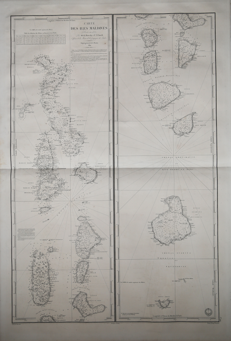
First French Edition of Moresby's Chart of the Maldives.
One of the earliest obtainable maps to focus on the Maldive Islands, based upon the surveys conducted by Robert Moresby in 1835.
Morseby's surveys of the Maldives were the first modern survey of the region and became the standard chart for decades thereafter. His first published sea charts were Chart of the Maldeeve, or Maldiva Islands; Reduced from the Large Scale in Three Sheets, Surveyed by Commander R. Moresby, and Lieutenant F.J. Powell, I.N. in 1836, and based upon his Trigonometrical Survey of the Maldive Islands (in 3 sheets), both of which are exceptionally rare on the market (OCLC locates 1 example of each).
Moresby's chart was quickly follows up by the present French charting of the region.
Robert Moresby (1794 – 1854) was a captain of the East India Company's Bombay Marine/Indian Navy who distinguished himself as a hydrographer, maritime surveyor and draughtsman. Moresby is best know for conducted the first modern survey the Red Sea (1829-32).
After the completion of the Red Sea Survey, Robert Moresby was sent to chart various coral island groups lying across the track of India-to-Cape trade. In 1834–36 Moresby, assisted by Lieutenants Christopher and Young, undertook the difficult cartography of the Maldive Islands, drawing the first accurate maritime charts of this complicated Indian Ocean atoll group (Admiralty Charts). These charts were printed as three separate large maps by the Hydrographic Service of the Royal Navy.
Moresby's survey of the Atolls of the Maldives was followed by the Chagos Archipelago. where he conducted "a thorough scientific survey". He planted 30 breadfruit trees in Diego Garcia Island, the largest of the group. Moresby reported that "there were cats and chickens on the island". Some of his observations were used by Darwin in his 1842 book "The Structure and Distribution of Coral Reefs."
Moresby's charts were so good that they were favored by Maldivian pilots navigating through the treacherous waters of their atolls until the 1990s, when satellite images appeared. In the Maldives a channel locally also known as Hanikandu, between Northern Maalhosmadulhu Atoll and "Fasdhūtere" Atoll, is still known as 'Moresby Channel'.
Dépôt des cartes et plans de la Marine
|
The Dépôt de la Marine, known more formally as the Dépôt des cartes et plans de la Marine, was the central charting institution of France. The centralization of hydrography in France began in earnest when Jean-Baptiste Colbert became First Minister of France in 1661. Under his watch, the first Royal School of Hydrography began operating, as did the first survey of France’s coasts (1670-1689). In 1680, Colbert consolidated various collections of charts and memoirs into a single assemblage, forming the core of sources for what would become the Dépôt.
The Dépôt itself began as the central deposit of charts for the French Navy. In 1720, the Navy consolidated its collection with those government materials covering the colonies, creating a single large repository of navigation. By 1737, the Dépôt was creating its own original charts and, from 1750, they participated in scientific expeditions to determine the accurate calculation of longitude.
In 1773, the Dépôt received a monopoly over the composition, production, and distribution of navigational materials, solidifying their place as the main producer of geographic knowledge in France. Dépôt-approved charts were distributed to official warehouses in port cities and sold by authorized merchants. The charts were of the highest quality, as many of France’s premier mapmakers worked at the Dépôt in the eighteenth century, including Philippe Bauche, Jacques-Nicolas Bellin, Rigobert Bonne, Jean Nicolas Buache, and Charles-François Beautemps-Beaupré.
The Dépôt continued to operate until 1886, when it became the Naval Hydrographic Service. In 1971, it changed names again, this time to the Naval and Oceanographic Service (SHOM). Although its name has changed, its purpose is largely the same, to provide high quality cartographic and scientific information to the France’s Navy and merchant marine.
|