| Reference: | MS3844 |
| Author | Guillaulme DE L'ISLE |
| Year: | 1730 ca. |
| Zone: | Sri Lanka |
| Printed: | Amsterdam |
| Measures: | 585 x 505 mm |
| Reference: | MS3844 |
| Author | Guillaulme DE L'ISLE |
| Year: | 1730 ca. |
| Zone: | Sri Lanka |
| Printed: | Amsterdam |
| Measures: | 585 x 505 mm |
Guillaume de l'Isle (1675-1726) was the son and pupil of the cartographer Jean Dominique Cassini, who, among other important contributions, aligned the study of astronomy to the study of geography. Under Cassini's direction, observations were made from locations all over the world that enabled longitudinal calculations to be made with much greater accuracy.
De l'Isle carried on this exacting work with remarkable dedication and integrity, constantly revising and improving his maps. While precision was his primary goal, his maps are invariably elegant and attractive. Jean (Johannes) Covens and Corneille (Cornelius) Mortier were brothers-in-law, who carried on the book publishing business established by Pierre Mortier in Amsterdam in 1685.
Pierre Mortier's company owed much of its success to his access to French publishers, whose publications he re-issued in handsome editions. The elder Mortier died in 1711; his wife continued the firm until she died in 1719. In 1721, Covens and Mortier formed a partnership, Covens having married Agatha Mortier in the same year. They continued the business by publishing enlarged editions of Sanson, Jaillot, and De L'Isle, as well as some of the later Dutch cartographical masters such as De Wit and Allard, and of course Pierre Mortier.
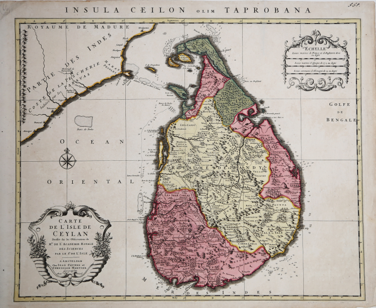
This map is from an edition of De L'Isle entitled, Atlas Nouveau, Contenant Toutes Les Parties Du Monde, Ou sont exactement Remarquées les Empires, Monarchies, Royaumes, Etats, Republiques &c. Par Guillaume de l'Isle. Premier Géographe de sa Majesté. It delineates the island in great detail.
At the time the map was made, the coastal areas were ruled by the Dutch East Indian Company, who were undoubtedly responsible for the soundings indicated around the island and for mapping the roads depicted. Copper engraving, contemporary colour, in perfect condition.
|
Koeman, C&M 7, 91. Dimensioni 585x480.
|
Guillaulme DE L'ISLE (1675 - 1726)
|
vershadowed by his more famous son, Guillaume.
Guillaume De L’Isle, (1675-1726) Premier Geographe to the French king, was probably the leading map-maker of the period. His work was important as marking a transition from the maps of the Dutch school, which were highly decorative and artistically-orientated, to a more scientific approach, which reduced the importance given to the decorative elements, and emphasized the scientific base on which their maps were constructed, out of which the modern school of cartography emerged. He was prominent in the recalculation of latitude and longitude, based on the most up-to-date celestial observations, and his major contribution was in collating and incorporating this information in his maps, setting a new standard of accuracy, quickly followed by many of his contemporaries, including the Dutch firm of Covens and Mortier.
Having learnt geography from his father, it is said that at the age of eight or nine he could draw maps to demonstrate ancient history. He studied mathematics and astronomy under J.D. Cassini, where he received the grounding in scientific cartography, that is the hallmark of his work.
His first atlas was published in about 1700, in 1702 he was elected a member of the Academie Royale des Sciences, and in 1718 became Premier Geographe du Roi. His maps of the newly explored parts of the world reflect the most up-to-date information available and did not contain fanciful detail in the absence of solid information.
After his death in 1726 his business was continued by his nephew Philippe Buache, and subsequently by J. Dezauche.
Joseph Nicholas De L’Isle (1688-1768), Guillaume’s brother, became a friend of Peter the Great and supplied him with information on the Russian Empire. He stayed in Russia for twenty-two years and was in charge of the Royal Observatory in St. Petersburg, returning to France in 1747, taking with him much of the material he had access to, particularly relating to explorations along the northern Pacific coasts of Russia and America, which he subsequently published. The Atlas Russicus was published in 1747 and contained twenty maps.
Simon Claude De L’Isle (1675-1726) was a historian. It is curious to note that he was born and died in the same years as his elder brother Guillaume.
|
|
Koeman, C&M 7, 91. Dimensioni 585x480.
|
Guillaulme DE L'ISLE (1675 - 1726)
|
vershadowed by his more famous son, Guillaume.
Guillaume De L’Isle, (1675-1726) Premier Geographe to the French king, was probably the leading map-maker of the period. His work was important as marking a transition from the maps of the Dutch school, which were highly decorative and artistically-orientated, to a more scientific approach, which reduced the importance given to the decorative elements, and emphasized the scientific base on which their maps were constructed, out of which the modern school of cartography emerged. He was prominent in the recalculation of latitude and longitude, based on the most up-to-date celestial observations, and his major contribution was in collating and incorporating this information in his maps, setting a new standard of accuracy, quickly followed by many of his contemporaries, including the Dutch firm of Covens and Mortier.
Having learnt geography from his father, it is said that at the age of eight or nine he could draw maps to demonstrate ancient history. He studied mathematics and astronomy under J.D. Cassini, where he received the grounding in scientific cartography, that is the hallmark of his work.
His first atlas was published in about 1700, in 1702 he was elected a member of the Academie Royale des Sciences, and in 1718 became Premier Geographe du Roi. His maps of the newly explored parts of the world reflect the most up-to-date information available and did not contain fanciful detail in the absence of solid information.
After his death in 1726 his business was continued by his nephew Philippe Buache, and subsequently by J. Dezauche.
Joseph Nicholas De L’Isle (1688-1768), Guillaume’s brother, became a friend of Peter the Great and supplied him with information on the Russian Empire. He stayed in Russia for twenty-two years and was in charge of the Royal Observatory in St. Petersburg, returning to France in 1747, taking with him much of the material he had access to, particularly relating to explorations along the northern Pacific coasts of Russia and America, which he subsequently published. The Atlas Russicus was published in 1747 and contained twenty maps.
Simon Claude De L’Isle (1675-1726) was a historian. It is curious to note that he was born and died in the same years as his elder brother Guillaume.
|