| Reference: | s28374 |
| Author | Girolamo RUSCELLI |
| Year: | 1561 ca. |
| Zone: | Hispaniola |
| Printed: | Venice |
| Measures: | 270 x 190 mm |
| Reference: | s28374 |
| Author | Girolamo RUSCELLI |
| Year: | 1561 ca. |
| Zone: | Hispaniola |
| Printed: | Venice |
| Measures: | 270 x 190 mm |
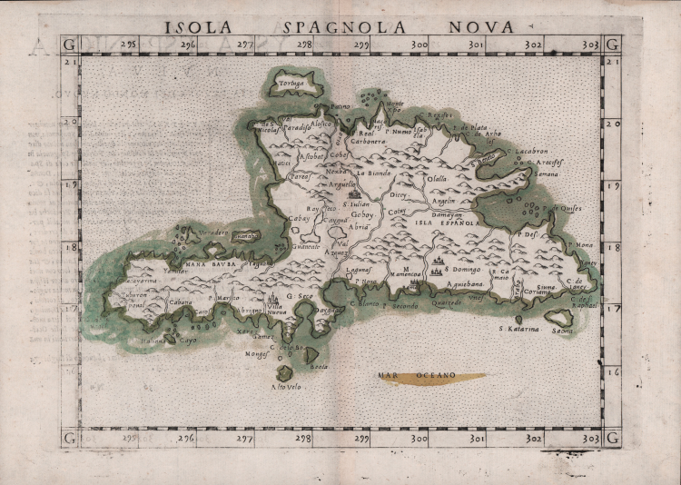
This important Ruscelli map of Hispaniola, is based on Gastaldi’s earlier map of the same region, dated 1548. Although the overall shape and orientation of the island are not entirely correct, many details are topographically accurate. Hispaniola is the second largest island in the West Indies, in the Greater Antilles of the Caribbean Sea. Cuba, Hispaniola, Jamaica, and Puerto Rico are collectively known as the Greater Antilles. These islands are made up of continental rock, as distinct from the Lesser Antilles, which are mostly young volcanic or coral islands.
The island has five major mountain ranges, all of which are delineated in the map. Major river systems are shown, and all cities, towns, settlements, fortifications and ports are depicted. The waters surrounding the island are rendered in stipple. Some islands in close proximity to Hispaniola are in place. Christopher Columbus landed on Hispaniola on December 5, 1492 and named it La Isla Española, "The Spanish Island," which was eventually Anglicized to Hispaniola. It is said that when he first laid eyes on its shores, he termed it "La Perle des Antilles”.
Hispaniola is the site of the first European settlement in the Americas, La Navidad (1492–1493), as well as the first proper town, La Isabela (1493–1500), and is also the first permanent settlement and current capital of the Dominican Republic, Santo Domingo dating to approximately 1498.
Etching with engraving, about 1561. Magnificent proof, printed on contemporary laid paper, with margins, in perfect condition. Example in wonderful contemporary coloring.
Map taken from Geographia di Claudio Tolomeo edited by Girolamo Ruscelli, published in Venice in several editions between 1561 and 1598. The maps is based on the Geografia by Giacomo Gastaldi (1548), who probably also personally drew these maps, which were engraved by the brothers Livio and Giulio Sanuto.
The peculiarity of these maps is that they are engraved two for plate and subsequently cut; this is why the copper sign only appears on three sides of the map. Ruscelli's text and his maps are considered to be the best modern atlas up to the first version of Abraham Ortelius' Theatrum Orbis Terrarum (1570).
Only their widespread diffusion prevents a sustained evaluation in the antiquarian market. In fact, the work had a first edition in 1561, printed by Vincenzo Valgrisi who also edited the 1562 reprint. There are three editions signed by Giordano Ziletti (two in 1564 and one in 1574), while in 1597 it was published by the Calignani brothers. All these editions contain 64 plates. In 1598 and 1599 the two editions edited by Giuseppe Rosaccio and printed by the heirs of Melchior Sessa came to light. These last two editions include 69 plates; in fact, Rosaccio's map of the planisphere and continents has been added.
Example of Ruscelli’s maps in contemporary coloring are absolutely rare.
Girolamo RUSCELLI (Viterbo 1504 – Venezia 1566)
|
Girolamo Ruscelli was an Italian humanist, publisher and cartographer active in Venice in the early 16th century. Born in Viterbo, Ruscelli lived in Aquileia, Padua, Rome and Naples before moving to Venice, where he spent most of his life. Cartographically, Ruscelli is best known for his important revision of Ptolemy's Geographia, published in 1561. Based on an expansion of Giacomo Gastaldi's 1548 work Ptolemy, Ruscelli added some 37 new “Ptolemaic” maps to his Italian translation of the Geographia. Ruscelli is also listed as the editor of such important works as Boccaccio's Decameron, Petrarch's verses, Ariosto's Orlando Furioso, and various other works. In addition to his well-known cartographic work, many scholars associate Ruscelli with Alexius Pedemontanus, author of the popular De' Secreti del R. D. Alessio Piemontese. This well-known work, or “Book of Secrets,” was a collection of scientific and quasi-scientific medical recipes, household advice and technical commentary on a range of subjects that included metallurgy, alchemy, dyeing and perfume making. Ruscelli, as Alexius, founded an “Academy of Secrets,” a group of nobles and humanists dedicated to the discovery of “forbidden” scientific knowledge. This was the first known experimental scientific society and was later imitated by numerous other groups throughout Europe, including the Academy of Secrets in Naples.
|